
Vila do Porto
| Vila do Porto | ||||||
|---|---|---|---|---|---|---|
|
||||||
| Basic data | ||||||
| Autonomous Region : | Azores | |||||
| Concelho : | Vila do Porto | |||||
| Coordinates : | 36 ° 57 ′ N , 25 ° 8 ′ W | |||||
| Residents: | 3119 (as of June 30, 2011) | |||||
| Surface: | 25.55 km² (as of January 1, 2010) | |||||
| Population density : | 122 inhabitants per km² | |||||
| Height: | 0 m | |||||
| Vila do Porto district | ||||||
|
||||||
| Residents: | 5552 (as of June 30, 2011) | |||||
| Surface: | 96.89 km² (as of January 1, 2010) | |||||
| Population density : | 57 inhabitants per km² | |||||
| Number of municipalities : | 5 | |||||
| administration | ||||||
| Administration address: | Câmara Municipal de Vila do Porto Largo de Nossa Senhora da Conceição 9580-539 Vila do Porto |
|||||
| President of the Câmara Municipal: | Carlos Henrique Lopes Rodrigues | |||||
| Website: | cm-viladoporto.pt | |||||


Vila do Porto ( [ ˈvilɐ ðu ˈpoɾtu ] ) is a small town ( Vila ) on the island of Santa Maria ( Azores ) belonging to Portugal with 3119 inhabitants (as of June 30, 2011).
history
Vila do Porto is the oldest city in the Azores. In 1432, when a member of the Order of the Knights of Christ landed, the island of Santa Maria was taken over by the Portuguese. Settlement began in 1439; In 1472 the town was granted city rights.
Public facilities
In Vila do Porto there is a primary school, a secondary school, a grammar school and a church. In addition, there has also been a health center (hospital with outpatient and inpatient care) for a number of years. In 2008 the port was expanded with a yacht area. Northwest of the city is the airport of the island of Santa Maria, which was built as a military base in 1944 .
Attractions
Fort São Brás stands on a hill above the port . The main church is the parish church Igreja Matriz Nossa Senhora da Assuncao . It was built in the 16th century, making it one of the oldest churches in the Azores. It was rebuilt after a major fire in 1832.
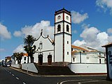
Igreja Matriz Nossa Senhora da Assuncao

The harbor

Forte de São Brás over the city


administration
Vila do Porto district
Vila do Porto is the seat of a district of the same name ( Município ). This circle covers the entire area of the island of Santa Maria. Its highest point is 587 m ( Pico Alto ). Formigas , 36 km northeast of the island of Santa Maria, is managed by the port authority in Vila do Porto.
The following municipalities belong to the district of Vila do Porto:

| local community | Population (2011) |
Area km² |
Density of population / km² |
LAU code |
|---|---|---|---|---|
| Almagreira | 599 | 11.22 | 53 | 410101 |
| Santa Bárbara | 405 | 15.27 | 27 | 410102 |
| Santo Espírito | 588 | 26.68 | 22nd | 410103 |
| Sao Pedro | 841 | 18.17 | 46 | 410104 |
| Vila do Porto | 3.119 | 25.55 | 122 | 410105 |
| Vila do Porto district | 5,552 | 96.89 | 57 | 4101 |
Population development
| Population in the Vila do Porto County (1849–2011) | |||||||||
| year | 1849 | 1900 | 1930 | 1960 | 1981 | 1991 | 2001 | 2004 | 2011 |
|---|---|---|---|---|---|---|---|---|---|
| Residents | 5,647 | 6,359 | 7.158 | 13,233 | 6,500 | 5,922 | 5,578 | 5.511 | 5,552 |
Municipal holiday
- June 24th
Town twinning
sons and daughters of the town
- António de Sousa Braga (* 1941), Bishop of Angra
Web links
- Official website
- Vila do Porto on www.azoren-online.com
- The island of Santa Maria on www.azoren-online.com
Individual evidence
- ↑ www.ine.pt - indicator resident population by place of residence and sex; Decennial in the database of the Instituto Nacional de Estatística
- ↑ a b Overview of code assignments from Freguesias on epp.eurostat.ec.europa.eu
- ↑ www.ine.pt - indicator resident population by place of residence and sex; Decennial in the database of the Instituto Nacional de Estatística
- ↑ Decreto-lei nº 265/72 de 31 de julho (PDF; 6.7 MB), accessed on February 9, 2017
- ↑ www.anmp.pt , accessed on August 30, 2013
