
Lagoa (Azores)
| Lagoa | ||||||
|---|---|---|---|---|---|---|
|
||||||
| Basic data | ||||||
| Autonomous Region : | Azores | |||||
| Concelho : | Lagoa | |||||
| Coordinates : | 37 ° 45 ′ N , 25 ° 35 ′ W | |||||
| Residents: | 14,442 (as of June 30, 2011) | |||||
| Surface: | 45.6 km² (as of January 1, 2010) | |||||
| Population density : | 317 inhabitants per km² | |||||
| Lagoa district | ||||||
|
||||||
| Residents: | 14,442 (as of June 30, 2011) | |||||
| Surface: | 45.6 km² (as of January 1, 2010) | |||||
| Population density : | 317 inhabitants per km² | |||||
| Number of municipalities : | 5 | |||||
| administration | ||||||
| Website: | lagoa-acores.pt | |||||
.png)


.PNG)
Lagoa is a small town on the Azores belonging island of São Miguel and has about 9000 inhabitants.
administration
Lagoa is the administrative seat of a district of the same name. The following five municipalities belong to the Lagoa district:
_2020.png)
| local community | Population (2011) |
Area km² |
Density of population / km² |
LAU code |
|---|---|---|---|---|
| Água de Pau | 3,058 | 17.46 | 175 | 420101 |
| Cabouco | 1.921 | 4.85 | 396 | 420102 |
| Nossa Senhora do Rosario | 5,396 | 6.52 | 827 | 420103 |
| Ribeira Chã | 396 | 2.50 | 159 | 420105 |
| Santa Cruz | 3,671 | 14.27 | 257 | 420104 |
| Lagoa district | 14,442 | 45.60 | 317 | 4201 |
Neighboring areas
| Ribeira Grande | ||
| Ponta Delgada |
.svg)
|
Vila Franca do Campo |
| Atlantic Ocean |
Attractions
The attraction of the place is a bathing complex, which consists of a combined natural and artificial swimming pool. Directly opposite is the fishing port of Porto dos Carneiros , which used to be the most important fishing port on the island.

The bath complex integrates open natural pools, ...

... flow-calmed natural pools, ...
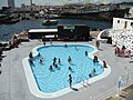
... as well as toddler pools. Opposite the old fishing port of Porto dos Carneiros
The rocks are included in the bathing operations in a suitable manner


sons and daughters of the town
- Manuel de Medeiros Guerreiro (1891–1978), theologian and missionary, Bishop of Nampula , Mozambique
Web links
Commons : Lagoa - collection of images, videos and audio files
- Official website of the Municipality of Lagoa (Portuguese)
- virtualazores.com - Website of the municipality of NS do Rosario (Lagoa, Portuguese / English)
- azoren-online.com
Individual evidence
- ↑ a b www.ine.pt - indicator resident population by place of residence and sex; Decennial in the database of the Instituto Nacional de Estatística
- ↑ a b Overview of code assignments from Freguesias on epp.eurostat.ec.europa.eu

Municípios of the Azores