
Mosteiros (Ponta Delgada)
| Mosteiros | ||||||
|---|---|---|---|---|---|---|
|
||||||
| Basic data | ||||||
| Autonomous Region : | Azores | |||||
| Concelho : | Ponta Delgada | |||||
| Coordinates : | 37 ° 54 ′ N , 25 ° 49 ′ W | |||||
| Residents: | 1123 (as of June 30, 2011) | |||||
| Surface: | 8.95 km² (as of January 1, 2010) | |||||
| Population density : | 125 inhabitants per km² | |||||
| Height: | 16 m | |||||
| Postal code : | 9555-156 | |||||
| politics | ||||||
| Mayor : | Carlos Manuel Silva Cabral | |||||
| Address of the municipal administration: | Junta de Freguesia de Mosteiros Rua das Pensões 1 9555-156 Mosteiros |
|||||


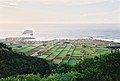
Mosteiros is a town and municipality in the extreme northwest of São Miguel , an island in the Portuguese archipelago of the Azores .
The former fishing village is right by the sea. Its name is traced back to the appearance of the largest of the offshore rock islands Ilhéus dos Mosteiros , which resembles that of a church ( Mosteiro , Portuguese for monastery).
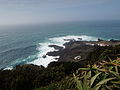
Mosteiros has a dark sandy beach and natural swimming pools, some of which are heated by hot springs. The entire coast of Mosteiros is exposed to the often strong surf of the Atlantic . Above the village, the Miradouro da Ponta do Escalvado viewpoint offers wide views over Mosteiros and the varied, partly steeply rising coast.
history
The place was probably settled since the late 15th century. The first parish church was built in the 16th century.
In the 19th century the place experienced a modest boom and two music groups were founded: the Banda Fundação Brasileira (1863) and the Banda Harmonia Mosteirense (1883), both of which are still important engines of social life in the municipality of Mosteiros.
Since the 1940s Mosteiros experienced a strong wave of emigration, especially to Canada and the USA, traditional emigration destinations of the Azores.
For a long time Mosteiros was considered an exemplary fishing village in the Azores, as one of the few places in the region located directly on the sea. Since the 1990s in particular, summer houses have increasingly been built around Mosteiros, both by Azoreans and by mainland Portuguese and foreigners, especially Germans.
administration

Mosteiros is the seat of a municipality of the same name ( Freguesia ) in the district ( Concelho ) of Ponta Delgada . 1123 inhabitants live in it (as of June 30, 2011).
The following places are in the municipality:
- Aldeia Velha
- Casa Nova
- Chão das Machadas
- Colmeal
- Fazenda Nova
- Feiteirona
- Joinal
- Lomba de Baixo
- Lomba de Cima
- Lombas
- Moeda Nova
- Mosteiros
- Pedras Brancas
- Pico de Mafra
- Pombal
- Outeiro
- Telhada
- Zuarte
traffic
Mosteiros is connected to the island's capital, Ponta Delgada, via the ER 1-1 coastal road, and to Ribeira Grande in the opposite direction . The nearest towns are João Bom in the east, Sete Cidades in the southeast and Várzea in the southwest, which can be reached via county roads.
Mosteiros has a small fishing port, from which excursion boats for whale watching leave.
Several times a day, the bus company Viação Micaelense connects Mosteiros with the capital, Ponta Delgada, partly via Capelas and partly via Várzea.
economy
The most important branch of the economy is agriculture , with cattle breeding being of primary importance. Fishing and the slowly increasing domestic and foreign tourism continue to play a lesser role .
gallery
View of Mosteiros

Natural swimming pool
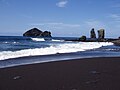
Beach with Ilhéus dos Mosteiros

sunset
Coastline around the natural swimming pool


Web links
- Website of the municipality of Mosteiros at the municipality of Ponta Delgada
- Entry on Mosteiros on the German-language website www.azoren-online.de
- Entry to Mosteiros in the Mapas de Portugal
supporting documents
- ↑ a b www.ine.pt - indicator resident population by place of residence and sex; Decennial in the database of the Instituto Nacional de Estatística
- ↑ Overview of code assignments from Freguesias on epp.eurostat.ec.europa.eu
- ↑ Entry of the parish church of Mosteiros in the Portuguese list of monuments SIPA, accessed on October 6, 2019
- ↑ Michael Bussmann: Azores. Michael Müller Verlag , Erlangen 2013, p. 191

Ajuda da Bretanha | Arrifes | Candelária | Capelas | Covoada | Fajã de Baixo | Fajã de Cima | Fenais da Luz | Feteiras | Ginetes | Livramento | Mosteiros | Pilar da Bretanha | Relva | Remédios | Santa Bárbara | Santa Clara | Santo António | São José | São Pedro | São Roque | São Sebastião | São Vicente Ferreira | Sete Cidades