
Fajazinha
| Fajazinha | ||||||
|---|---|---|---|---|---|---|
|
||||||
| Basic data | ||||||
| Autonomous Region : | Azores | |||||
| Concelho : | Lajes das Flores | |||||
| Coordinates : | 39 ° 26 ′ N , 31 ° 15 ′ W | |||||
| Residents: | 76 (as of June 30, 2011) | |||||
| Surface: | 6.16 km² (as of January 1, 2010) | |||||
| Population density : | 12 inhabitants per km² | |||||
| Postal code : | 9960-110 | |||||
| politics | ||||||
| Mayor : | Paulo Eduardo Avelar Rodrigues | |||||
| Address of the municipal administration: | Junta de Freguesia de Fajãzinha Rua Nossa Senhora do Rosário 9960-110 Fajãzinha |
|||||
| Website: | www.cmlajesdasflores.pt/municipio/juntas/fajazinha.php | |||||


Fajãzinha is a freguesia (municipality) in the Lajes das Flores district on the Azores island of Flores . The Ribeira Grande, the largest stream on the island, flows through the municipality and falls 300 meters from the plateau in a waterfall. The closest places are Fajã Grande in the north and Mosteiro in the south. Fajãzinha was not connected to the island's road network until the 1950s.
Not far from the central Rossio square is the three-aisled church Igreja Nossa Senhora dos Remedios , built from 1776 to 1783 . It is considered to be one of the most beautiful churches on Flores. The place has a small cheese dairy and outside, on the road to Fajã Grande, a water mill . Above the village is the picturesque Poço da Alagoinha pond , which is fed by numerous waterfalls.
gallery

Fajazinha

Rossio square with Igreja Nossa Senhora dos Remedios church
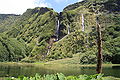
Poço da Alagoinha


Individual evidence
- ↑ www.ine.pt - indicator resident population by place of residence and sex; Decennial in the database of the Instituto Nacional de Estatística
- ↑ Overview of code assignments from Freguesias on epp.eurostat.ec.europa.eu
Web links
- Fajãzinha - the small village in the Azores Online

Fajã Grande | Fajãzinha | Fazenda | Lajedo | Lajes das Flores | Lomba | Mosteiro