Porto Santo
| Porto Santo | ||
|---|---|---|
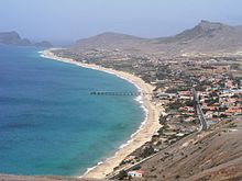
| Panorama of Porto Santo | ||
| Waters | Atlantic Ocean | |
| Archipelago | Madeira | |
| Geographical location | 33 ° 4 ′ N , 16 ° 21 ′ W | |
|
|
||
| length | 11.6 km | |
| width | 6 km | |
| surface | 42.17 km² | |
| Highest elevation | Pico do Facho 517 m |
|
| Residents | 5482 (June 30, 2011) 130 inhabitants / km² |
|
| main place | Vila Baleira | |
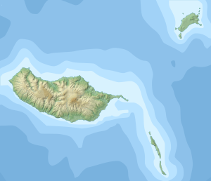
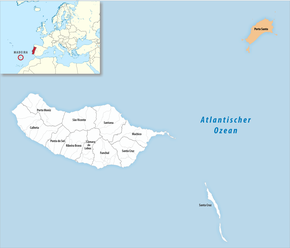
| Map of Porto Santo | ||
Porto Santo ( German "Holy Port" ) is a Portuguese island in the Atlantic , about 42 km northeast of Madeira and part of the Madeira archipelago .
Porto Santo is about eleven kilometers long and no more than six kilometers wide. The inhabitants live mainly from fishing and tourism , for which the nine kilometer long sandy beach is particularly attractive.
history
When the Portuguese navigators João Gonçalves Zarco , Tristão Vaz Teixeira and Bartolomeu Perestrelo "rediscovered" the Madeira archipelago in 1418, they first entered Porto Santo to check the possibility of settling Madeira from here. A pregnant rabbit abandoned in 1418 reproduced very rapidly, so that after a few years the first settlers suffered from a large rabbit plague.
In 1420, Bartolomeu Perestrelo received the island from Henry the Navigator, which was then still overgrown with dragon tree forests, scrub and macchia, as a fief. From the beginning, the lack of water made farming difficult on Porto Santo. Cattle breeding, on the other hand, was more promising than on Madeira thanks to the flat areas, which is why Porto Santo is still the meat supplier for the larger neighboring island.
In 1479, Christopher Columbus married Dona Filipa de Perestrelo e Moniz , the daughter of Bartolomeu Perestrelo, who was governor of the island at the time and who had already participated in an expedition of the aforementioned seafarers to Porto Santo in 1420. Columbus then lived on the island with his wife for a few years; It is not entirely clear to what extent the plans for his later trips to Porto Santo came about. Until the 18th century, Porto Santo was repeatedly the victim of attacks by English, French and Moorish pirates . For protection, a small fortress was built on the Pico do Facho, of which nothing is preserved today.
Landscape image

The first settlers of Porto Santo found a wooded island with many dragon trees as well as a lot of juniper and tree heather . Ten plant species are endemic only to Porto Santo, another 29 are otherwise only found in the Madeira archipelago. Heavy clearing has meant that Porto Santo is largely treeless today; As part of reforestation projects, many new trees were planted between Vila Baleira and the airport, which belong to the Porto Santo Natural Park. Nevertheless, the overall landscape impression of Porto Santo remains, especially in comparison with Madeira, which is a bare island, which is also related to the very dry climate and the fact that there are no rivers.
Attractions
Most tourists visit Porto Santo because of the nine kilometer long sandy beach of Campo de Baixo , which is all the more attractive as Madeira itself has hardly any sandy beaches. Porto Santo is visited not only by tourists, but also by many residents of Madeira, especially on weekends. In Vila Baleira there is the Casa Museu Cristovão Columbo , a museum in the house that was probably once inhabited by Christopher Columbus. The 517 meter high Pico do Facho in the east is of volcanic origin and offers a good view of the island. In the west there are interesting basalt formations on the southern slope of the Pico de Ana Ferreira .
Transport links
The ferries need around 2 ½ hours to travel between Madeira and the port of Porto Santo Santo. They run daily in the summer months of July, August and September (twice on Fridays and Sundays) and every other day except Tuesday. (As of 2018)
In the 1960s, NATO built an airport on Porto Santo , from where Madeira can be reached in 20 minutes; there are also flight connections to Lisbon and Porto . In the summer of 2014, Porto Santo was flown to directly from Germany for the first time. Starting in summer 2017, Condor will be offering weekly flights between Düsseldorf and Porto Santo.
administration
| Porto Santo District | |||||
|---|---|---|---|---|---|
|
|||||
| Residents: | 5482 (as of June 30, 2011) | ||||
| Surface: | 42.59 km² (as of January 1, 2010) | ||||
| Population density : | 129 inhabitants per km² | ||||
| Number of municipalities : | 1 | ||||
| administration | |||||
| Administration address: | Câmara Municipal de Porto Santo Rua Dr. Nuno Silvestre Teixeira (Edifício de Serviços Públicos) 9400-162 Porto Santo |
||||
| President of the Câmara Municipal: | Roberto Paulo Cardoso da Silva ( PSD ) | ||||
| Website: | www.cm-portosanto.pt | ||||
The main town on the island is Vila Baleira on the flat south coast. Almost all of the residents of Porto Santo live here. Porto Santo is one of the six Portuguese counties that encompass only a single municipality ( freguesia ).
Individual evidence
- ↑ www.ine.pt - indicator resident population by place of residence and sex; Decennial in the database of the Instituto Nacional de Estatística
- ↑ Overview of code assignments from Freguesias on epp.eurostat.ec.europa.eu


