Sao Vicente (Madeira)
| Sao Vicente | ||||||
|---|---|---|---|---|---|---|
|
||||||
| Basic data | ||||||
| Autonomous Region : | Madeira | |||||
| Concelho : | Sao Vicente | |||||
| Coordinates : | 32 ° 48 ′ N , 17 ° 3 ′ W | |||||
| Residents: | 3136 (as of June 30, 2011) | |||||
| Surface: | 44.14 km² (as of January 1, 2010) | |||||
| Population density : | 71 inhabitants per km² | |||||
| Height: | 271 m | |||||
| Postal code : | 9240-225 | |||||
| politics | ||||||
| Mayor : | Eduardo Paulo Mendes de Andrade ( PSD ) | |||||
| Address of the municipal administration: | Junta de Freguesia de Sao Vicente Vila de Sao Vicente 9240-225 Sao Vicente |
|||||
| Website: | www.jfsaovicente.ifreg.pt | |||||
| Sao Vicente County | ||||||
|
||||||
| Residents: | 5721 (as of June 30, 2011) | |||||
| Surface: | 78.83 km² (as of January 1, 2010) | |||||
| Population density : | 73 inhabitants per km² | |||||
| Number of municipalities : | 3 | |||||
| administration | ||||||
| Administration address: | Câmara Municipal de São Vicente Paços do Município 9240-225 |
|||||
| President of the Câmara Municipal: | Jorge Orlando César de Jesus Romeira ( PSD ) | |||||
| Website: | www.cm-saovicente.pt | |||||
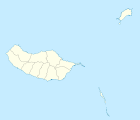
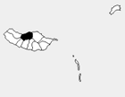
São Vicente (Portuguese for Saint Vincent ) is a small town ( Vila ) and a district ( concelho ) on the north coast of the Portuguese island of Madeira . The district has 3136 inhabitants (as of June 30, 2011).
coat of arms
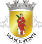
In gold a barefoot looking saint with a red and gold cloak holding a palm frond over his right shoulder. A silver four-tower wall crown over the shield . In the white band at the base of the shield, the name in black letters for the São Vicente "VILA DE S. VICENTE".
The flag, which is quartered in gold and red, has the coat of arms in the middle.
history
After João Gonçalves Zarco rediscovered the island of Madeira, the Portuguese began to settle the island of Madeira for the first time in 1419 . In the middle of the 15th century, São Vicente was founded as an independent municipality. In 1744 the place was elevated to a vila . The São Vicente district was downsized in 1835 when the new Santana and Porto Moniz districts were established . After the new districts were temporarily dissolved again in 1895 and the regional taxes were withdrawn, the district boundaries from 1835 were re-established in 1898 and are still valid today. The São Vicente district consists of the municipalities of São Vicente, Ponta Delgada, and Boaventura.
Culture and sights
Sights include the grutas (grottos), ancient lava channels that can be explored. In the associated visitor center , volcanism and the formation of Madeira is explained.
The baroque parish church Igreja de São Vicente dates from the 18th century . The small chapel Capelinha do Calhau from 1692 is, facing inland, built in a rock niche in the middle of the river mouth.
The Casa Museu Horácio Bento de Gouveia in the birthplace of the writer, poet and journalist Horácio Bento de Gouveia (1901–1983) is dedicated to the life and work of the poet.
A large number of miradouros are set up on the edge of various hiking trails in a circle and offer wide views.
administration
Sao Vicente County
The São Vicente district is divided into three parishes ( freguesias ):
| local community | Population (2011) |
Area km² |
Density of population / km² |
LAU code |
|---|---|---|---|---|
| Boaventura | 1,226 | 25.30 | 48 | 311001 |
| Ponta Delgada | 1,359 | 9.39 | 145 | 311002 |
| Sao Vicente | 3.136 | 44.14 | 71 | 311003 |
| Sao Vicente County | 5,721 | 78.83 | 73 | 3110 |
Neighboring areas:
| Atlantic Ocean | ||
| Porto Moniz |

|
Santana |
| Ponta do Sol | Câmara de Lobos and Ribeira Brava |
Population development
| 1849 | 1900 | 1930 | 1960 | 1981 | 1991 | 2001 | 2004 | 2011 |
|---|---|---|---|---|---|---|---|---|
| 11,454 | 8,104 | 9,684 | 11,603 | 8,501 | 7,695 | 6,198 | 6,063 | 5,721 |
Municipal holiday
- 22nd of January
Town twinning
traffic
From São Vicente, the only road across the island, the R104, leads south to Ribeira Brava. The well-developed road R101 (in sections VE1 and VE2) with many tunnels leads next to the old road from the 1950s to Porto Moniz in the west. Only the old spectacular, sometimes single-lane, road R101 leads east (as of 2007) via Ponta Delgada and Boaventura to Santana .
Rodoeste -Verkehrsgesellschaft bus routes ensure public transport in the district. Lines 6, 139 and 150 run several times a day to the south (Funchal), west (Porto Moniz or Santa) and east (Arco de São Jorge), but at a low frequency (less than every two hours).
Web links
Individual evidence
- ↑ www.ine.pt - indicator resident population by place of residence and sex; Decennial in the database of the Instituto Nacional de Estatística
- ↑ a b Overview of code assignments from Freguesias on epp.eurostat.ec.europa.eu
- ↑ www.ine.pt - indicator resident population by place of residence and sex; Decennial in the database of the Instituto Nacional de Estatística
- ↑ www.monumentos.pt (under Cronologia ), accessed on August 31, 2013
- ↑ History page of the district website , accessed on August 31, 2013
- ↑ www.anmp.pt , accessed on August 31, 2013
- ↑ Timetables on the Rodoeste website ( Memento of the original from February 10, 2014 in the Internet Archive ) Info: The archive link has been inserted automatically and has not yet been checked. Please check the original and archive link according to the instructions and then remove this notice. , accessed on August 31, 2013


