
Machico
| Machico | ||||||
|---|---|---|---|---|---|---|
|
||||||
| Basic data | ||||||
| Autonomous Region : | Madeira | |||||
| Concelho : | Machico | |||||
| Coordinates : | 32 ° 43 ′ N , 16 ° 46 ′ W | |||||
| Residents: | 11,256 (as of June 30, 2011) | |||||
| Surface: | 17.49 km² (as of January 1, 2010) | |||||
| Population density : | 644 inhabitants per km² | |||||
| Height: | 0 m | |||||
| Machico district | ||||||
|
||||||
| Residents: | 21,828 (as of June 30, 2011) | |||||
| Surface: | 68.33 km² (as of January 1, 2010) | |||||
| Population density : | 319 inhabitants per km² | |||||
| Number of municipalities : | 5 | |||||
| administration | ||||||
| Administration address: | Câmara Municipal de Machico Largo do Município 9200-099 Machico |
|||||
| President of the Câmara Municipal: | Ricardo Miguel Nunes Franco ( PS ) | |||||
| Website: | www.cm-machico.pt | |||||


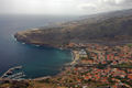
Machico is a city in the east of the Portuguese Atlantic island of Madeira . It is the oldest place on the island .
history
In July 1419, the Portuguese explorers João Gonçalves Zarco , Tristão Vaz and Bartolomeu Perestrelo first set foot on Madeira Island in the Bay of Machico.
King D. João I distributed the land to his three deserving captains as part of the settlement of the island (1420-1425). Tristão Vaz was appointed captain of the eastern part of the island based in Machico, where his statue still stands today. Bartolomeu Perestrelo received the captaincy district of Porto Santo, and João Gonçalves Zarco received the southwest half of Madeira, which he administered from Funchal . The captains had far-reaching powers: They could levy taxes on land, sugar mills, ovens and salt and they were allowed to hand over fallow land to landlords at their own discretion. Machico soon developed into a center of sugar cane cultivation, but could not keep up with the metropolis of Funchal, where the most suitable soils for sugar cane were.
In 1494 only one fifth of the harvest came from the Machico legacy. When the Portuguese crown placed Madeira under the king's control in 1497, Funchal had long since overtaken its competitor economically.
Machico was granted city rights on August 2, 1996, making it the second largest city on the island.
Attractions
In Machico there are Madeira's oldest church, the Capela dos Milagres , the parish church (15th century) in the center and the São Roque chapel near the hotel with its famous tile paintings.
There is a local history museum in the Solar do Ribeirinho , a restored manor house on Rua do Ribeirinho. The São João Baptista Fort was built in the 18th century.
tourism
Machico has a hotel, several guest houses and numerous restaurants. The traditional dishes that are offered in good restaurants include, for example, the sopa de trigo, a wheat soup, the carne de vinho e alhos , pieces of meat marinated in wine and garlic and the bolo de caco , a flatbread baked on a hot stone (caco) , which is often served warm as a starter with a garlic butter spread. The traditional machico dishes are very tasty.
Since 2009 there has been an artificially created sandy beach , a rarity on the island (otherwise only in Calheta ). The sand was imported from Morocco. At low tide , black sand appears on the adjacent pebble beach.
Madeira Airport with its spectacular taxiway built on concrete piles is located on the slope of the cliff near Machico . The space between the concrete piles under the runway has meanwhile been converted into a sports and leisure center ("Parque Desportivo Água de Pena") for tennis, squash, badminton, handball, jogging etc. in the area belonging to Machico.
To the east of Machico is the Pico do Facho viewpoint (322 m above sea level). From here the view extends over the runway of Santa Catarina Airport in the west and the bay of Machico over the town of Caniçal to the eastern tip of Madeira, the promontory of Ponta de São Lourenço .
Machico with Santa Catarina Airport

View of the Machico transport hub

View of the beach promenade with the forum

Machico Marina
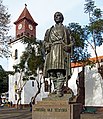
Monument to Tristão Vaz Teixeira

Chapel of the Lord of Miracles

Monument to the founders of Machico
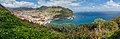
View of the beach and the port, in the background the Ponta de São Lourenço


administration
Machico district

| local community | Population (2011) |
Area km² |
Density of population / km² |
LAU code |
|---|---|---|---|---|
| Água de Pena | 2,434 | 5.15 | 473 | 310401 |
| Caniçal | 3,924 | 11.85 | 331 | 310402 |
| Machico | 11,256 | 17.49 | 644 | 310403 |
| Porto da Cruz | 2,597 | 25.22 | 103 | 310404 |
| Santo Antonio da Serra | 1,617 | 8.62 | 188 | 310405 |
| Machico district | 21,828 | 68.33 | 319 | 3104 |
| Atlantic Ocean | ||
| Santana |
.svg)
|
Atlantic Ocean |
| Santa Cruz |
Population development
| Population in Machico County (1849–2011) | ||||||||
|---|---|---|---|---|---|---|---|---|
| 1849 | 1900 | 1930 | 1960 | 1981 | 1991 | 2001 | 2011 | |
| 5,491 | 11,820 | 17,936 | 21,606 | 22,126 | 22,016 | 21,747 | 21,803 | |
Municipal holiday
- 9th October
Town twinning
-
 Madeira Beach , Florida, USA
 -
 Lajes do Pico , Azores, Portugal
 -
Povoação , Azores, Portugal
sons and daughters of the town
- Francisco Álvares de Nóbrega (1773–1806), writer
- José Tolentino Mendonça (* 1965), clergyman, university professor and poet
- Nuno Malo (* 1977), film composer
- Nuno Miguel Fidalgo dos Santos (* 1982), football player
- Nuno Viveiros (* 1983), football player
- Élio Bruno Teixeira Martins (* 1985), football player
Web links
- Concelho website (Portuguese)
- Aeroporto da Madeira - Madeira Airport / Funchal Airport (English)
- Landing report on the old, extremely short runway ( Memento from June 5, 2013 in the Internet Archive )
Individual evidence
- ↑ www.ine.pt - indicator resident population by place of residence and sex; Decennial in the database of the Instituto Nacional de Estatística
- ↑ a b Overview of code assignments from Freguesias on epp.eurostat.ec.europa.eu
- ↑ www.ine.pt - indicator resident population by place of residence and sex; Decennial in the database of the Instituto Nacional de Estatística
Calheta | Câmara de Lobos | Funchal | Machico | Ponta do Sol | Porto Moniz | Porto Santo | Ribeira Brava | Santa Cruz | Santana | Sao Vicente