
Ponta de Sao Lourenço
| Ponta de Sao Lourenço | ||
 The north side of the Ponta de São Lourenço (2013) |
||
| Geographical location | ||
|
||
| Coordinates | 32 ° 44 ′ 45 ″ N , 16 ° 42 ′ 0 ″ W | |
| Waters 1 | Atlantic Ocean | |
| length | 9 km | |
| width | 2 km | |
 View from the west (2010), the Ilhas Desertas in the background on the right |
||

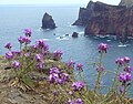
The Ponta de São Lourenço ( German "Sankt-Lawrence -spitze" ) is a cape and nature reserve on the island of Madeira . It belongs to the area of the municipality of Caniçal in the Machico district and includes the easternmost tip of Madeira, two offshore islands ( Ilhéu da Cevada and Ilhéu do Farol ) and smaller rocks in the Atlantic.
Geology and geography
.JPG)
Like all of Madeira, the Ponta de São Lourenço is of volcanic origin. It consists of dark trachyte and light or reddish tuff . In some places trachyte ducts lead almost vertically upwards; here cracks in the rock have filled with magma from below . On the north coast of the peninsula, steep cliffs have been created by erosion , the south side slopes slightly more gently. The highest elevations on the headland are the Pico do Furado (150 m) and the Piedras Brancas (163 m).
On the south side of the peninsula there is a wooden hut for bird watching.
In the far east, on the Ilhéu do Farol, a lighthouse was put into operation in 1870. It is known as Farol da Ponta de São Lourenço and is the oldest lighthouse in Madeira. The name of the small island is derived from him ( Ilhéu do Farol = lighthouse island).
In 2007, six wind turbines were built on the peninsula . A fish farm is operated in the bay on the south side .
Flora and fauna
The Ponta de São Lourenço was declared a nature reserve in 1982 and later to the Habitats Directive fauna in the Natura 2000 network of European Union added. It is part of the Parque Natural da Madeira and is one of the eight Important Bird Areas in the region.
In contrast to Madeira's interior, the Ponta de São Lourenço has little rainfall and is largely treeless. In addition to grasses, succulents , milk spot thistles and Madeira horn clover grow here . The endemic plants that can be found on the Ponta de São Lourenço also include the magnificent adder's head ( Echium nervosum ) and the Madeiran levkoje ( Matthiola maderensis ).

Blooming ice herb

Magnificent adder head
Madeira Levkoye
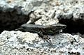
Madeira lizard
.jpg)
.jpg)
_-_May_2007.jpg)

Madeira lizards are common on the Ponta de São Lourenço. In addition, the peninsula is the habitat of the Canary Island pipit , the Barolo shearwater ( Puffinus baroli , used to be a subspecies of the small shearwater ) and the monarch butterfly .
tourism


A hiking trail leads to the eastern end of the main island. The Ilhéu da Cevada (also known as Ilhéu de Agostinho ) rises only a few meters further to the southeast, to which the Ilhéu do Farol (also known as Ilhéu de Fora ) joins in a southeastern direction . Both islands are not open to visitors.
The hiking trail consists of rocky and gravel paths, which are supplemented in some places by wooden walkways. It leads up and down over stone stairs, a total of around 300 meters in altitude (there and back) .
A former farmhouse, the Casa do Sardinha, now serves as the visitor center for the Ponta de São Lourenço. It houses an exhibition on the peninsula set up by the nature conservation authority and a souvenir shop, in front of which there are picnic benches. Palm trees provide shade there.
literature
- Peter Mertz: Madeira - hiking guide + map , 2nd edition, KOMPASS maps, Innsbruck 2017, ISBN 978-3-99044-156-5 , p. 17, p. 28
- Susanne Lipps: Madeira - DuMont Reise-Taschenbuch , 6th, updated edition, DuMont Reiseverlag, Ostfildern 2018, ISBN 978-3-7701-7525-3 , p. 180