
Calheta (Madeira)
| Calheta | ||||||
|---|---|---|---|---|---|---|
|
||||||
| Basic data | ||||||
| Autonomous Region : | Madeira | |||||
| Concelho : | Calheta | |||||
| Coordinates : | 32 ° 43 ′ N , 17 ° 11 ′ W | |||||
| Residents: | 3163 (as of June 30, 2011) | |||||
| Surface: | 23.45 km² (as of January 1, 2010) | |||||
| Population density : | 135 inhabitants per km² | |||||
| Calheta County | ||||||
|
||||||
| Residents: | 11,521 (as of June 30, 2011) | |||||
| Surface: | 111.51 km² (as of January 1, 2010) | |||||
| Population density : | 103 inhabitants per km² | |||||
| Number of municipalities : | 8th | |||||
| administration | ||||||
| Administration address: | Câmara Municipal da Calheta Avenida Dom Manuel I nº46 9370–135 Vila da Calheta |
|||||
| Website: | www.cm-calheta-madeira.com | |||||


Calheta ( [ kɐˈʎetɐ ] ) is a Portuguese city on the island of Madeira and is located about 32 km from Funchal in the west of the island. It is considered the most important municipality in southwest Madeira. This small place used to be the center of sugar production.
He has a newly built marina , and sand from Figueira da Foz (Portugal) and from Morocco ( Sahara ) was embarked to create two artificial sandy beaches .
Calheta County
Calheta is the seat of the district of the same name, which has around 12,000 inhabitants; the neighbors are Porto Moniz in the north, São Vicente in the northeast and Ponta do Sol in the east.
The district of Calheta is divided into eight parishes ( freguesias ):
_2020.png)
| local community | Population (2011) |
Area km² |
Density of population / km² |
LAU code |
|---|---|---|---|---|
| Arco da Calheta | 3,168 | 14.70 | 216 | 310101 |
| Calheta | 3.163 | 23.45 | 135 | 310102 |
| Estreito da Calheta | 1,607 | 14.32 | 112 | 310103 |
| Fajã da Ovelha | 895 | 22.16 | 40 | 310104 |
| Jardim do Mar | 204 | 0.74 | 277 | 310105 |
| Paul do Mar | 871 | 1.40 | 623 | 310106 |
| Ponta do Pargo | 909 | 24.71 | 37 | 310107 |
| Prazeres | 704 | 10.03 | 70 | 310108 |
| Calheta County | 11,521 | 111.51 | 103 | 3101 |
| Neighborhoods of Calheta | ||
|---|---|---|
|
Northwest: Atlantic Ocean |
North: Porto Moniz |
Northeast: São Vicente |
|
West: Atlantic Ocean |
.svg)
|
East: Ponta do Sol |
|
South: Atlantic Ocean |
||
population
| Calheta Population Statistics, 1849-2011 | |||||||||
|---|---|---|---|---|---|---|---|---|---|
| year | 1849 | 1900 | 1930 | 1960 | 1981 | 1991 | 2001 | 2004 | 2011 |
| Residents | 15,279 | 18,266 | 21,990 | 21,799 | 12,954 | 13.005 | 11,946 | 11,856 | 11,519 |

Jardim do Mar
Paul do Mar
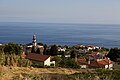
Arco da Calheta

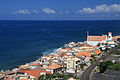
Calheta beach and marina (rear)

Promenade at the marina of Calheta


.jpg)


religion
sons and daughters of the town
- José Vicente de Freitas (1869–1952), military and politician, Prime Minister 1928/29
Individual evidence
- ↑ www.ine.pt - indicator resident population by place of residence and sex; Decennial in the database of the Instituto Nacional de Estatística
- ↑ a b Overview of code assignments from Freguesias on epp.eurostat.ec.europa.eu
- ↑ www.ine.pt - indicator resident population by place of residence and sex; Decennial in the database of the Instituto Nacional de Estatística
Web links
Calheta | Câmara de Lobos | Funchal | Machico | Ponta do Sol | Porto Moniz | Porto Santo | Ribeira Brava | Santa Cruz | Santana | Sao Vicente