Câmara de Lobos
| Câmara de Lobos | ||||||
|---|---|---|---|---|---|---|
|
||||||
| Basic data | ||||||
| Autonomous Region : | Madeira | |||||
| Concelho : | Câmara de Lobos | |||||
| Coordinates : | 32 ° 39 ′ N , 16 ° 58 ′ W | |||||
| Residents: | 17,986 (as of June 30, 2011) | |||||
| Surface: | 7.74 km² (as of January 1, 2010) | |||||
| Population density : | 2324 inhabitants per km² | |||||
| Postal code : | 9300 | |||||
| politics | ||||||
| Mayor : | Higino Teles | |||||
| Address of the municipal administration: | Junta de Freguesia de Câmara de Lobos Rua S. João de Deus 11 e 13 9300-051 Câmara de Lobos |
|||||
| Website: | www.freguesiacamaradelobos.pt | |||||
| Câmara de Lobos county | ||||||
|
||||||
| Residents: | 35,666 (as of June 30, 2011) | |||||
| Surface: | 52.14 km² (as of January 1, 2010) | |||||
| Population density : | 684 inhabitants per km² | |||||
| Number of municipalities : | 5 | |||||
| administration | ||||||
| Administration address: | Câmara Municipal de Câmara de Lobos Praça da Autonomia 9304-001 Câmara de Lobos |
|||||
| President of the Câmara Municipal: | Arlindo Pinto Gomes ( PSD ) | |||||
| Website: | www.cm-camaradelobos.pt | |||||
Câmara de Lobos is a Portuguese city on the island of Madeira and is known as the Maderir fishing village.
description
The city gained fame after the British Prime Minister Winston Churchill immortalized the place in a painting. A memorial plaque in the town center reminds of this historical event. The place name means cave of the monk seals . Today, however, monk seals are rarely sighted on this stretch of coast.
Estreito de Câmara de Lobos , the most important growing area for Madeira wine, extends above the city . The Cabo Girão rises to the west , the second highest steep cliff in the world (height: 580 m).
To the east of the city is the only steam power plant on the island, as well as a brewery and cement silos, where the embarked from the motherland cement is stored.
coat of arms
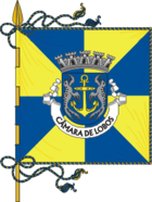
In blue a golden anchor accompanied by two silver erect, facing seals. Over the shield a silver five-tower wall crown . In the white band at the base of the shield, the place name in black letters "CÂMARA DE LOBOS".
Câmara de Lobos county
The county of Câmara de Lobos is divided into five parishes ( freguesias ).
| local community | Population (2011) |
Area km² |
Density of population / km² |
LAU code |
|---|---|---|---|---|
| Câmara de Lobos | 17,986 | 7.74 | 2,325 | 310201 |
| Curral das Freiras | 2,001 | 25.03 | 80 | 310202 |
| Estreito de Câmara de Lobos | 10,269 | 7.87 | 1,305 | 310203 |
| Jardim da Serra | 3,311 | 7.36 | 450 | 310205 |
| Quinta Grande | 2,099 | 4.14 | 507 | 310204 |
| Câmara de Lobos county | 35,666 | 52.14 | 684 | 3102 |
| Neighboring districts of Câmara de Lobos | ||
|---|---|---|
|
North: São Vicente |
Northeast: Santana |
|
|
West: Ribeira Brava |

|
East: Funchal |
|
South: Atlantic Ocean |
||
Population development
| year | 1849 | 1900 | 1930 | 1960 | 1981 | 1991 | 2001 | 2008 | 2011 |
|---|---|---|---|---|---|---|---|---|---|
| Residents | 12,391 | 17,468 | 21,806 | 29,759 | 31,035 | 31,476 | 34,614 | 36,119 | 35,659 |

Town twinning
Câmara de Lobos has had a town partnership with the Italian municipality of Forio on the island of Ischia since 2008 .
religion
sons and daughters of the town
- Rúben Micael (* 1986), football player
Individual evidence
- ↑ www.ine.pt - indicator resident population by place of residence and sex; Decennial in the database of the Instituto Nacional de Estatística
- ↑ a b Overview of code assignments from Freguesias on epp.eurostat.ec.europa.eu
- ↑ www.ine.pt - indicator resident population by place of residence and sex; Decennial in the database of the Instituto Nacional de Estatística


