Lake Uri
| Lake Uri | ||
|---|---|---|

|
||
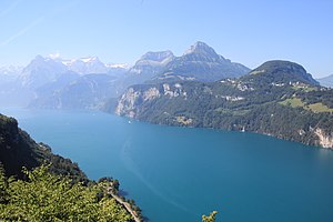
| View from Morschach to Lake Uri | ||
| Geographical location | Cantons of Uri , Schwyz | |
| Tributaries | Reuss | |
| Drain | ( Vierwaldstättersee in Lucerne ) Reuss | |
| Places on the shore | Brunnen , Sisikon , Flüelen , building | |
| Location close to the shore | Altdorf | |
| Data | ||
| Coordinates | 688 356 / 199 791 | |
|
|
||
| Altitude above sea level | 434 m above sea level M. | |
| surface | 26.825 km² | |
| length | 11.6 km | |
| width | 2.7 km | |
| volume | 3,567,725 km³ | |
| Maximum depth | 200 m | |
| Middle deep | 133 m | |
| Catchment area | 924 km² | |
|
particularities |
Sea part |
|

|
||
|
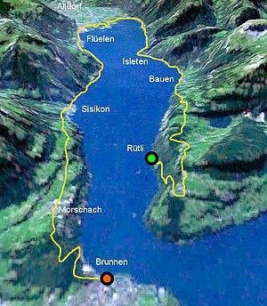
Swiss Path around Lake Uri (the south is on this map at the top of the picture) |
||
The Urnersee is a part of the Vierwaldstättersee in the cantons Uri and Schwyz .
location
Distinctive places for expansion and location are Brunnen in the north and Flüelen in the south. The approx. 12 km long part of the lake is 26.8 km² and has an average depth of 133 m and a maximum of 200 m. Thanks to the mild climate, hemp palms , figs , chestnuts and other Mediterranean plants thrive on the banks .
Huge mountains protrude from the water on both sides and are reminiscent of a Norwegian fjord . The Rütli is located on the western bank of its northern part. This is where the Swiss journey begins . The Schillerstein protrudes from the water near it . The east bank is characterized by the Axenstrasse , on which the Tell Chapel is located.
Lake Uri is suitable for windsurfers because of the foehn and the thermal winds blowing in summer .
In 1977 the alleged sea monster Urnie (based on Nessie ) was named after Lake Uri . In fact, Urnie was a dummy made for the television show Teleboy .
Shallow water zones
With the gravel from the excavation of the Flüelen bypass tunnel and the Gotthard Base Tunnel (construction phase until 2010), shallow water zones were created again, which had disappeared due to the gravel mining. Some islands were also formed, the Neptune Islands and the Lorelei archipelago . Some of the islands are bird sanctuaries .
Shipping
On the lake part, the ships of the Shipping Company of the Vierwaldstättersee (SGV) operate in regular services (courses) on the SGV main line Lucerne – Brunnen – Flüelen through the lake from the north to the start of the lake in the south at these ship stations:
- From the bay of Gersau : from / to Brunnen SGV
- West bank: Seedorf , Isleten - Isenthal , Bauen , Rütli
- East bank: Sisikon , Tellsplatte , Flüelen
Web links
- Flüelen municipality - geography and mountains. Municipality of Flüelen, accessed on June 2, 2016 .
- Interactive 360 ° panorama of Lake Uri
- Seeschütti Uri
Individual evidence
- ↑ Berchtesgaden National Park: The Königssee. A limnological project study. 1982. Berchtesgaden National Park Administration, p. 31 , accessed on May 13, 2016 (PDF, 15.6 MB).
- ↑ Map of the Reuss Delta (PDF) , accessed on June 9, 2015.
