
Göscheneralpsee
| Göscheneralpsee | |||||||
|---|---|---|---|---|---|---|---|
 |
|||||||
|
|||||||
|
|||||||
| Coordinates | 680 064 / 166 537 | ||||||
| Data on the structure | |||||||
| Lock type: | Rockfall dam | ||||||
| Construction time: | 1960 | ||||||
| Height of the barrier structure : | 155 m | ||||||
| Height above the river bed : | 106 m | ||||||
| Building volume: | 9 300 000 m³ | ||||||
| Crown length: | 540 m | ||||||
| Operator: | Kraftwerk Göschenen AG, Göschenen | ||||||
| Data on the reservoir | |||||||
| Altitude (at congestion destination ) | 1792 m above sea level M. | ||||||
| Water surface | 1.32 km² | ||||||
| Reservoir length | 2.3 km | ||||||
| Storage space | 75 000 000 m³ | ||||||
| Total storage space : | 76 000 000 m³ | ||||||
| Catchment area | 42.3 km² | ||||||
| Design flood : | 300 m³ / s | ||||||
| Particularities: |
Highest rock embankment in Switzerland |
||||||
 |
|||||||

The Göscheneralpsee is a reservoir in the municipality of Göschenen in the Swiss canton of Uri , which is used to operate the Göschenen power plant and is located in the Uri Alps at 1792 m above sea level. M. height is.
location
The reservoir can be reached from Göschenen through the Göschenertal . The 11 km long road was built in 1944. The Göschenertal lies between the Susten Pass and the Furka Pass . Around the lake are the peaks Sustenhorn (3503 m high), Dammastock (3630 m) and Galenstock (3586 m).
history
The lake was created as a replacement for the unrealized reservoir in the Urserental , which would have been used to operate the Urseren power plant . Soil mechanical investigations were carried out from 1952 to 1955 . In 1960 the dam on the Göscheneralp was completed. The former settlement of Göscheneralp, namely Hinteralp , nine kilometers west of Göschenen, has disappeared in the reservoir. The houses and the church were dismantled and flooded. Its residents moved to the hamlet of Gwüest, which belongs to the municipality of Göschenen .
technology

The dam is designed as a planted earth dam, the wall height is 155 m, the dam crown is 540 m long. The dam is 700 m wide at the foundation. The storage basin with a capacity of around 75 million cubic meters collects the water from the Göschenertal, the Voralptal - a northern side valley of the Göschenertal, and from the upper Urserental . The Chelenreuss and Dammareuss from the upper Göschenertal flow directly into the storage basin , the Voralpreuss and Stockbach are captured and fed into the reservoir through the Voralpental feeder. The water of the Furkareuss also reaches the lake from a water intake at the Tiefenbach train station via the Hinteres Urserental supply line . This supply also receives water from the water intake of the Lochbergbach above Realp . The reservoir supplies the Göscheneralp – Göschenen stage of the Göschenen power plant with water.
photos

Göscheneralpsee from Älprigen on the southern slope
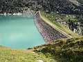
Dam (east side)

Göscheneralpsee from the southwest


See also
Web links
- Lakes in Switzerland: Natural and storage lakes, Federal Office for the Environment FOEN, 2007 ( Memento from October 5, 2008 in the Internet Archive ) → Lakes in Switzerland (PDF)
literature
- Fritz Ringwald: The Göschenen power plant. Geographical study on the utilization of the Reuss. In: Geographica Helvetica 18 (1963), p. 305 ff. ( Digitized version )
Individual evidence
- ^ Kraftwerke Göschenen AG: Kraftwerk Göschenen AG: History. In: www.kw-goeschenen.ch. Retrieved October 12, 2016 .
- ^ Fritz Ringwald: The Göschenen power station: Geographical study on the utilization of the Reuss . In: Geographica Helvetica . tape 18 , no. 4 , 1963, pp. 305-314 , doi : 10.5169 / seals-44946 .
- ^ Georg Kaufmann: Hinteralp and Gwüest: Settlement history of the Göscheneralp . Gisler, Altdorf 1998, ISBN 978-3-9521208-5-9 .
Swiss reservoirs with a content of over 10 million m³:
Albignasee |
Arnensee |
Lac de Barberine |
Lago Bianco |
Lac Brenet |
Lago dei Cavagnöö |
Lac de Cleuson |
Lai da Curnera |
Davosersee |
Lac des Dix |
Lac d'Emosson |
Engstlensee |
Gelmersee |
Gigerwaldsee |
Göscheneralpsee |
Lake Gruyère |
Griessee |
Grimselsee |
Lac de l'Hongrin |
Klingnau Reservoir |
Klöntalersee |
Lake Lei |
Limmerensee |
Lake Livigno |
Lake Lucendro |
Lungerersee |
Lake Luzzone |
Lai da Marmorera |
Mattmarksee |
Lac de Mauvoisin |
Lac de Moiry |
Lac de Montsalvens |
Lac de Moron |
Muttsee |
Lai da Nalps |
Lake Naret |
Oberaarsee |
Lac de Pérolles |
Lake Poschiavo |
Raeterichsbodensee |
Lake Ritóm |
Lac de Salanfe |
Lago del Sambuco |
Schiffenensee |
Sihlsee |
Lai da Sontga Maria |
Sufnersee |
Lac des Toules |
Lake Tremorgio |
Lac de Tseuzier |
Lac du Vieux Emosson |
Lake Vogorno |
Wägitalersee |
Wohlensee |
Zervreila Lake