Dammareuss
| Dammareuss | ||
|
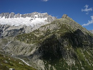
The Dammareuss (left in the picture) |
||
| Data | ||
| Water code | CH : 11085 | |
| location | Canton of Uri ; Switzerland | |
| River system | Rhine | |
| Drain over | Göschener Reuss → Reuss → Aare → Rhine → North Sea | |
| source | on the northern part of the Dammaglacier 46 ° 38 ′ 42 ″ N , 8 ° 26 ′ 21 ″ E |
|
| Source height | approx. 2770 m above sea level M. | |
| muzzle | in the Göscheneralpsee coordinates: 46 ° 38 ′ 40 " N , 8 ° 28 ′ 23" E ; CH1903: 679 189 / 166 427 46 ° 38 '40 " N , 8 ° 28' 23" O |
|
| Mouth height | 1792 m above sea level M. | |
| Height difference | approx. 978 m | |
| Bottom slope | approx. 30% | |
| length | 3.3 km | |
| Catchment area | 10.43 km² | |
| Discharge at the estuary A Eo : 10.43 km² |
MQ Mq |
730 l / s 70 l / (s km²) |
| Communities | Göschenen | |
The Dammareuss is an approximately 3 kilometer long tributary of the Göscheneralpsee in the Swiss canton of Uri . It runs entirely in the municipality of Göschenen in the southwest of the canton.
course
The Dammareuss rises at about 2360 m above sea level. M. on the Winterberg massif below the Dammastock the northeastern part of the Dammagletscher . It initially flows to the east and then turns to the southeast on the western slope of the Moosstock below the Dammahütte . Here it takes several other outflows from the Dammagletscher from the right.
It reaches the bottom of the dam , where it turns to the northeast and another important stream flows into it from the right. After another 800 meters, the Dammareuss flows out at 1792 m above sea level. M. from right into the Göschener Reuss, which is dammed up here to the Göscheneralpsee .
Individual evidence
- ↑ a b c Geoserver of the Swiss Federal Administration ( information )
- ↑ a b Modeled mean annual discharge. In: Topographical catchment areas of Swiss waters: sub-catchment areas 2 km². Retrieved August 27, 2017 .
