
Göschener Reuss
|
Göschener Reuss Älplerreuss, Chelenreuss |
||
 The customs bridge over the Göschener Reuss in Göschenen |
||
| Data | ||
| Water code | CH : 715 | |
| location | Canton of Uri ; Switzerland | |
| River system | Rhine | |
| Drain over | Reuss → Aare → Rhine → North Sea | |
| source | on the Chelen Glacier 46 ° 40 ′ 59 ″ N , 8 ° 25 ′ 21 ″ E |
|
| Source height | up to approx. 2766 m above sea level M. | |
| muzzle | at Göschenen in the Reuss coordinates: 46 ° 40 '3 " N , 8 ° 35' 31" E ; CH1903: 688252. / 169 108 46 ° 40 '3 " N , 8 ° 35' 31" O |
|
| Mouth height | approx. 1062 m above sea level M. | |
| Height difference | approx. 1704 m | |
| Bottom slope | approx. 14% | |
| length | 12.4 km | |
| Catchment area | 92.8 km² | |
| Discharge at the estuary A Eo gauge : 92.8 km² |
MQ Mq |
5.77 m³ / s 62.2 l / (s km²) |
| Left tributaries | Pre-alp price | |
| Right tributaries | Dammareuss , Alpergenbach | |
| Reservoirs flowed through | Göscheneralpsee | |
| Communities | Göschenen | |
The Göschener Reuss is a 12.4 kilometer long left tributary of the Reuss in the municipality of Göschenen in the southwest of the canton of Uri .
course
The Göschener Reuss rises at the Chelen Glacier and flows first in a south-easterly direction through the Chelenalptal , only to flow into the Göscheneralpsee a little later . It now flows through the Göschenertal in a north-easterly direction and takes the Voralpreuss from the left at Wiggen , its most important tributary. The Göschener Reuss now flows another 4.5 km and finally flows into the Reuss at Göschenen.
gallery

Göschenerreuss in winter (2018)
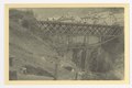
Göschenerreuss Bridge, photo taken before 1918
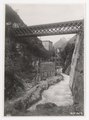
Göschenen, Göschenerreussbrücke, construction of the new bridge pier, photo from June 19, 1919

Web links
Individual evidence
- ↑ a b c Geoserver of the Swiss Federal Administration ( information )
- ↑ Length ( Memento of the original from August 19, 2014 in the Internet Archive ) Info: The archive link was inserted automatically and has not yet been checked. Please check the original and archive link according to the instructions and then remove this notice. Hydrological Atlas of Switzerland
- ↑ Modeled mean annual discharge. In: Topographical catchment areas of Swiss waters: area outlets. Retrieved August 14, 2016 .