
Dammaglacier
| Dammaglacier | ||
|---|---|---|
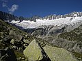
 Dammagletscher from Hüttenweg to Dammahütte |
||
| location | Uri , Switzerland | |
| Mountains | Uri Alps | |
| Type | Slope glacier | |
| length | 2.5 km | |
| surface | 5 km² | |
| Exposure | east | |
| Altitude range | 3300 m above sea level M. - 2060 m above sea level M. (2007) | |
| Tilt | ⌀ 40 ° (84%) | |
| Coordinates | 676 168 / 165159 | |
|
||
| drainage | Dammareuss , Göscheneralpsee , Göschener Reuss , Reuss | |
| particularities | one of the best researched alpine glaciers | |

The Dammagletscher is a slope glacier on the eastern slope of the Winterberg massif in the Uri Alps , in the canton of Uri in Switzerland . It is 2.5 km long and covers an area of approximately 5 km².
Origin and further course
The Dammagletscher takes its starting point at around 3300 m below the steep rock face on the eastern flank of the Dammastock . The glacier stretches to the east as a wide firn field and has a gradient of over 40% on the slope. In the south it is flanked by the Gletschhorn ( 3305 m above sea level ) and the Winterstock ( 3203 m above sea level ). A narrow tongue extends further down the valley and ends at an altitude of 2060 m . From here the Dammareuss flows into the dammed Göscheneralpsee , whose outlet, the Göschener Reuss , flows into the Reuss at Göschenen . In the north, the Dammagletscher is connected to the Rotfirn , another 1 km² large firn field on the eastern slope of the Winterberg.
Glacier fluctuations
The Dammagletscher is one of the world's most widely studied glaciers. Its expansion has been documented since 1921. A research network with the Zurich ETH and other Swiss, German and Anglo-Saxon universities continuously record temperature, humidity, rainfall, the nitrogen content of the ambient air and every receding of the tongue. At the end of the Little Ice Age around 1850, almost all Alpine glaciers had the greatest expansion in the last three centuries. The Dammagletscher reached down to the valley where the Göscheneralpstausee is located today. Since 1850, the retreat of the Dammagletscher has been interrupted several times by short intermediate advances.
tourism
At the Moosstock below the Dammagletscher stands at 2439 m above sea level. M. the Dammahütte of the Swiss Alpine Club SAC, which serves as a starting point for mountaineering and climbing tours in the winter mountain range.

Dammagletscher and Göscheneralpsee
Dammaglacier

Dammahütte with flagpole (to the right of the glacier on the ridge)

View from the Bergseehütte to the southwest
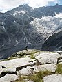
at the bottom left of the picture is the tongue cut off from the nutrient area and covered by the rock debris ( dead ice )


literature
- Editor of the Swiss Lexicon, Glacier Commission of the Swiss Academy of Natural Sciences (ed.): Glaciers, snow and ice. The lexicon on glaciology, snow and avalanche research in Switzerland . Verlag Schweizer Lexikon Mengis + Ziehr , Lucerne 1993, ISBN 3-9520144-2-7
Web links
- Federal Research Institute for Forests, Snow and Landscape WSL: Snow hydrological research in partially glaciated catchment areas
- Water worlds Göschenen
- Dammahütte: hiking tour climbing
- Glacier archive: glaciers in Switzerland
Individual evidence
- ↑ a b c Expert Commission for Cryosphere Measurement Networks (EKK) of the Swiss Academy of Sciences (SCNAT): The Swiss Glaciers 2005/2006 and 2006/2007. Glaciological Report No. 127/128. 2011 ( online ; PDF; 5.5 MB)
- ^ Research institute for hydraulic engineering, hydrology and glaciology (VAW) of the ETH Zurich : Dammagletscher. In: Glacier Natural Hazards. ( ethz.ch ( page no longer available ), also as a PDF ( page no longer available )).
- ^ Editing of the Swiss Lexicon, Glacier Commission of the Swiss Academy of Natural Sciences (ed.): Glaciers, snow and ice. Page 7f, Verlag Schweizer Lexikon Mengis + Ziehr, Horw / Luzern 1993, ISBN 3-9520144-2-7
- ↑ Die Zeit of November 13, 2009: Climate Change - Watching Die