
Sulzfeld (Baden)
| coat of arms | Germany map | |
|---|---|---|
_COA.svg)
|
Coordinates: 49 ° 6 ' N , 8 ° 51' E |
|
| Basic data | ||
| State : | Baden-Württemberg | |
| Administrative region : | Karlsruhe | |
| County : | Karlsruhe | |
| Height : | 204 m above sea level NHN | |
| Area : | 18.76 km 2 | |
| Residents: | 4806 (December 31, 2018) | |
| Population density : | 256 inhabitants per km 2 | |
| Postcodes : | 75056, 75031, 75059 | |
| Area code : | 07269 | |
| License plate : | KA | |
| Community key : | 08 2 15 082 | |
| Address of the municipal administration: |
At Rathausplatz 1 75056 Sulzfeld |
|
| Website : | ||
| Mayoress : | Sarina benefactor | |
| Location of the community Sulzfeld in the district of Karlsruhe | ||
  |
||

Sulzfeld is a municipality in the Karlsruhe district in Baden-Württemberg . Before the district reform in Baden-Württemberg, Sulzfeld belonged to the Sinsheim district .
geography
location
Sulzfeld is located in the eastern Kraichgau and western Stromberg area , between the Black Forest and the Odenwald , the Rhine and the Neckar . It is traversed by the Kohlbach , which drains over the Kraichbach to the Rhine. The community belongs to the regional association Middle Upper Rhine .
Community structure
The municipality of Sulzfeld includes the village of Sulzfeld, the hamlet of Neuhof , the village of Ravensburg and the Egonmühle, Gießhübelmühle and Seemühle farms. The deserted hamlet is located in the municipality .
history

Sulzfeld was first mentioned in a document in the Hirsauer Codex in 1075 . During the time of the tribal duchies, the place was in the Duchy of Franconia . The history of the place is closely connected with the Ravensburg , whose construction began around 1200, and the family of the Barons Göler von Ravensburg . After the defeat of the Protestants in the Schmalkaldic War , Spanish mercenaries devastated the place. Sulzfeld was also destroyed several times during the Thirty Years War . In 1939 there were 2304 inhabitants, at the end of 1945 there were 2455.
In 1801 a group of settlers from Sulzfeld founded a village east of the town of Łódź , which at that time belonged to South Prussia , called Neu-Sulzfeld . Today it is part of Łódź under the name Nowosolna .
Religions
Bernhard Göler von Ravensburg introduced the Reformation in Sulzfeld in 1522 . This made the place one of the first congregations to convert to the Lutheran faith. The current Protestant church was built in 1885/86.
politics

Municipal council
The municipal council has 14 honorary members who are elected for five years. In addition, the mayoress is the municipal council chairwoman with voting rights.
The 2019 local elections led to the following result (in brackets: difference to 2014):
| Municipal Council 2019 | ||||
|---|---|---|---|---|
| Party / list | Share of votes | Seats | ||
| Citizens' Association (BV) | 52.7% (+10.5) | 7 (+1) | ||
| CDU | 26.9% (+2.2) | 4 (+1) | ||
| Free greens | 11.9% (+11.9) | 2 (+2) | ||
| SPD | 8.5% (−13.3) | 1 (−2) | ||
| Turnout: 64.3% (+7.7) | ||||
Mayoress
Sarina Pfründer, who was elected on May 2, 2010 with 83.6 percent of the votes cast, has been mayor since 2010. The turnout was 73.7 percent. The predecessor Eberhard Roth had been mayor of the community for 40 years and did not run for the election.
coat of arms
Blazon : "A bare right arm emerging in blue from a silver cloud on the right edge of the shield with a short silver sleeve holding a golden ear."
Partnerships
The community of Sulzfeld maintains partnership relationships with
- the city of Avize in France since 1967,
- the city of El Cajon in California , USA since 1976 and
- the city of Nowosolna in Poland since 2014.
Yellow sandstone
The yellow Sulzfeld “ reed sandstone ” was a popular building material, it was easy to work with and had a long service life. The Romans already quarried the sandstones from the Sulzfeld quarries for two villae rusticae . Statues of gods and saints were also made from this yellow sandstone. They used the overburden to fortify the extensive Kraichgau streets. In the excavation field in Stettfeld , six sandstone boxes were found made from the yellow sandstone that came from Sulzfeld.
Ravensburg, built in the 13th century, was built entirely with the yellow sandstone from its own quarries.
Up until the 16th century, all local quarries were subordinate to the Barons von Göler. After that, a usufruct was also approved for the Sulzfeld citizens.
Quarries
There were four quarries in Sulzfeld, all of which were abandoned.
- 1. The Jägersitz quarry with an area of 2.5 hectares was the oldest and largest.
- 2. The Schaibener quarry was the second largest and was on the road to Ochsenburg .
- 3. The Jägerfritz-Streinbruch was on the Kohlbachwald.
- 4. The Rieth quarry was the smallest quarry, it was located in the Riethwald on the beech hump.
Sandstone building

Various buildings that still exist today were built with the yellow sandstone. In Karlsruhe these are, for example:
- Federal Court of Justice , the fire station , the infantry barracks , the Lessing grammar school and some residential buildings in Weinbrennerstrasse, Yorkstrasse and Nelkenstrasse.
Other sandstone buildings:
- Post offices in Mannheim , Heidelberg , Heilbronn and Pforzheim
- School in Weinheim
- Protestant churches in Forst and Sulzfeld, including the parish office
- Schoolhouse in Grötzingen
- Orphanage in Rastatt
- Ridge battlements of the Freiburg Christ Church
- Parts of the Strasbourg Cathedral
- Badischer Bahnhof in Basel
Economy and Infrastructure
Industry
In addition to a few smaller companies in the metal and wood processing industry, the Blanco company is located in Sulzfeld, which mainly produces electronic controls and heating plates for kitchen stoves and equipment for large kitchens. The company Pottiez (stamping and toolmaking), a supplier for u. a. the space industry, is resident.
Agriculture
The area around the community is characterized by agricultural use. Particularly noteworthy here is the very distinctive area of viticulture . There are extensive vineyards around the village , which are cultivated by private winemakers and members of a wine cooperative . The lords of the castle also produce their own wine and sell it in the Ravensburg restaurant and in the winery in the Rentamt . The cultivation of Trollinger and Lemberger , which is more likely to be grown in the Württemberg regions, is quite unusual for the Baden region . With 100 hectares of vineyards, the Sulzfeld community is one of the largest wine-growing communities in North Baden .
traffic
Sulzfeld is connected to the Kraichgaubahn ( Karlsruhe - Heilbronn ), on which the S4 light rail runs in the Karlsruhe transport association . The community is located on the federal road 293 (Heilbronn - Pfinztal ). Direct neighboring communities and connected to Sulzfeld by state and district roads are Kürnbach , Zaisenhausen and Mühlbach. The village of Ochsenburg can also be reached via a district road through the Ochsenburg Forest. In the future, the traffic infrastructure in Sulzfeld is to be improved.
education
In Sulzfeld there is a primary and secondary school with a Werkrealschule . There are also two communal and one Protestant kindergarten in town.
The adult education center in Sulzfeld is a public institution for continuing education. As a branch office, it is under the legal sponsorship of the non-profit association adult education center in the Karlsruhe district . In accordance with its statutory mandate, it also devotes itself to youth education in addition to adult education.
Culture and sights
building

- The most famous sight of the community is the Ravensburg . The accessible keep of the castle, which was built in its present form on a mountain above the village in the 13th century, offers a wonderful view over the rolling hills of the Kraichgau and is a popular destination.
- There are other stately buildings in the village with the Amalienhof and the former rent office . The Amalienhof is a mansion of the Göler von Ravensburg, built around 1600 for the first time, named after Amalia Göler, b. Reck was named. Today there is a dental clinic in a renovated farm building of the Amalienhof. The Rentamt, also called Mittleres Schloss and Pforzheimer Schloss, now houses the Göler winery. At the Protestant church , the oldest parts of which date from the 15th century and which received its current floor plan through renovation in 1885, there is also the Göler burial place with several ornate historical epitaphs.
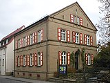
- Classified as a town house converted old schoolhouse from 1896 houses a local history museum and the gallery of the Cultural Committee.
- Sulzfeld is also rich in historical buildings, which document both the half-timbered construction of the 17th and 18th centuries as well as stone arable bourgeois properties from the 19th century.
- The town hall is a functional building from 1965, which was partially clad with sandstone typical of the region during a renovation in 1995. A sandstone figure from the 17th century, which was once in the palace garden, is kept in the town hall.
- Made of yellow sandstone

Protestant church
Evangelical rectory

Göler burial place

Göler tomb

Renaissance portal at the Rentamt

Half-timbered house from 1778

Local well

Amalienhof


Sons and daughters of the church
- Gottlieb Friedrich Machtholf (1735–1800), Lutheran pastor in late Pietism
- Franz Wilhelm August Göler von Ravensburg (1809–1862), Major General General of Baden and military writer
Individual evidence
- ↑ State Statistical Office Baden-Württemberg - Population by nationality and gender on December 31, 2018 (CSV file) ( help on this ).
- ^ The state of Baden-Württemberg. Official description by district and municipality. Volume V: Karlsruhe District Kohlhammer, Stuttgart 1976, ISBN 3-17-002542-2 . Pp. 123-124
- ↑ Communications from the Württ. And Bad. State Statistical Office No. 2: Results of the population census on December 31, 1945 in North Baden
- ↑ Otto Heike: 150 Years of Swabian Settlements in Poland 1795-1945 . O. Heike, 1979 ( google.pl [accessed June 2, 2020]).
- ^ State Statistical Office of Baden-Württemberg: Municipal elections 2019, Sulzfeld ; Sulzfeld municipality: municipal council elections 2019 (PDF) and municipal council elections 2014 (PDF) ; accessed July 6, 2019.
- ↑ sprache.de ( page no longer available , search in web archives ) Info: The link was automatically marked as defective. Please check the link according to the instructions and then remove this notice. Retrieved January 3, 2013
- ↑ Manfred Himmel, Sulzfelder Sandsteine, Steinbrüche und Steinhauer online version .
- ↑ http://www.stimme.de/kraichgau/nachrichten/Sandsteinmaennchen-bekom-Platz-im-Rathaus;art1943,2578251
Remarks
- ↑ These quarries were in the Längenfeld area and on the border to Zaisenhausen .
-
↑ The sandstone boxes had a size of 70/70/60 cm with a 10 cm thick closure plate.
A wine amphora found in it indicates its use as a "refrigerator". - ↑ The Jägersitz quarry was on the boundary between Sulzfeld and Mühlbach (Eppingen) above the Fröschberg and south of the Lichtenberg.
- ↑ Presumably named after the officer and baron Friedrich Fritz von Göler , who was passionate about hunting. The stones for the Sulzfeld war memorial (1914–1918) were removed from the quarry in 1934.
- ↑ It was exploited with masonry and lintel stones for building houses until 1900 and then abandoned.
literature
- Bernd Breitkopf / Kurt Hochstuhl: Sulzfeld. From farmers, stone cutters and noblemen. Edited by the community of Sulzfeld. Ubstadt-Weiher, regional culture publisher 1997. ISBN 978-3-929366-59-4 .
- Klaus Rössler: Family book (Ortssippenbuch) Sulzfeld (district of Karlsruhe), created on the basis of local sources and church registers from 1638 to 1957 . 2nd Edition. Sulzfeld: Municipality of Sulzfeld 2004 (= Badische Ortssippenbücher 97)
Web links
- Website of the municipality of Sulzfeld
- Sulzfeld Historic : Detailed, previously unpublished background information about Sulzfeld. Historical and current issues.

Cities: Bretten | Bruchsal | Ettlingen | Kraichtal | Oestringen | Philippsburg | Rheinstetten | Stutensee | Waghausel . Municipalities: Bad Schönborn | Dettenheim | Eggenstein-Leopoldshafen | Forst (Baden) | Gondelsheim | Graben-Neudorf | Hambrücken | Carlsbad (Baden) | Karlsdorf-Neuthard | Kronau | Kürnbach | Linkenheim-Hochstetten | Malsch | Marxzell | Oberderdingen | Oberhausen-Rheinhausen | Pfinztal | Sulzfeld (Baden) | Ubstadt-Weiher | Waldbronn | Walzbachtal | Weingarten (Baden) | Zaisenhausen .