
Stone glacier

.JPG)
The Steingletscher is a valley glacier south of the Susten Pass in the Urner Alps , in the far east of the canton of Bern , Switzerland . It has a length of 4.3 km and covers an area of almost 8 km².
The stone glacier takes its starting point on the ridge between the Gwächtenhorn ( 3420 m above sea level ) in the west and the Sustenhorn in the east. From here the glacier flows north along the western flank of the Kleiner Sustenhorn ( 3318 m above sea level ) and the Sustenspitz ( 2931 m above sea level ). The glacier tongue is currently at 2000 m above sea level. M. above the Steinsee (Swisstopo: Steisee); another tongue overlaps the ridge between the Tierbergli and the Bockberg. The glacier drains into the stone water that flows through the Gadmertal and flows into the Aare as Gadmerwasser near Innertkirchen .
In its upper part, the Steingletscher is connected to the Steinlimigletscher towards the west via firn fields on the northern slope of the Gwächtenhorn . This is 2.8 km long and covers an area of 2.5 km². It flows northwards from the Tierberg parallel to the Steingletscher, bordered by the Tierbergli in the east and the Giglistock ( 2900 m above sea level ) in the west. Its glacier tongue lies at 2120 m above sea level. M. The drain flows into the stone water below the stone lake .
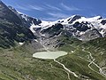
During the high stage of the Little Ice Age around the middle of the 19th century, the stone glacier was around 1 km longer than it is today. During the retreat of the twelve was formed in 1940 in the plane of the former glacier tongue hectares large Steinsee at an altitude of 1934 m above sea level. M.
In contrast to the Valais glaciers, z. B. Arolla , the 1850s terminal and lateral moraine are still relatively close to today's glacier bed. If you look at the surrounding peaks ( Sustenhorn , Hinter Tierberg, Dammastock , Tieralplistock and Diechterhorn), they are 3400-3500 m high (ridge framing). This results in a very large catchment area if the 3000 m isotherm is defined as the boundary between catchment and consumption area. Overall, there have been fewer advances here since 1850, despite the larger catchment area and the greater thickness of the ice. There were vigorous advances in 1912–1921 and 1969–1981 by almost 300 meters.

View from the Susten Pass to the Steingletscher and Steinsee, on the far right the Steinlimigletscher, in the middle behind the Gwächtenhorn , as of 2003
Same view in 2020. The retreat of the glacier is clearly visible.


At the top of the Tierbergli ridge is at 2795 m above sea level. M. the Tierberglihütte of the Swiss Alpine Club SAC. It serves as a starting point for mountain climbs as well as for the alpine glacier hike to the south over the 3,089 m above sea level. M. high Sustenlimi in the Chelenalptal (rearmost part of the Göschenertal ).
literature
Guide through the Steinalp glacier path on the Sustenpass / Meiringen region Hasliberg. Working group Glacier Path Steinalp, Meiringen 1996
Web links
- Research institute for hydraulic engineering, hydrology and glaciology (VAW) of the ETH Zurich : Steingletscher. In: Glacier Natural Hazards. ( ethz.ch ( page no longer available ), also as a PDF ( page no longer available )).
- Interactive before and after comparison pictures of the Steingletscher
Individual evidence
- ↑ Guide through the Steinalp glacier path on the Sustenpass / Meiringen region Hasliberg. Working group Glacier Path Steinalp, Meiringen 1996, page 23
Coordinates: 46 ° 42 ′ 43 " N , 8 ° 26 ′ 14" E ; CH1903: 676 355 / 173901