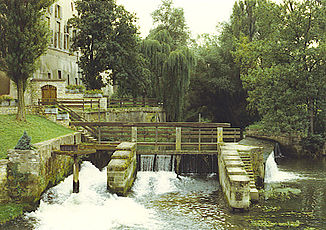
Nied (river)
|
Nied Nied Française |
||
|
The course of the Nied |
||
| Data | ||
| Water code | FR : A9--0120 , DE : 2648 | |
| location |
France
|
|
| River system | Rhine | |
| Drain over | Saar → Moselle → Rhine → North Sea | |
| source | in the municipality of Marthille 48 ° 55 ′ 18 ″ N , 6 ° 33 ′ 45 ″ E |
|
| Source height | approx. 273 m | |
| muzzle | in the municipality of Rehlingen-Siersburg in the Saar Coordinates: 49 ° 23 '39 " N , 6 ° 39' 59" E 49 ° 23 '39 " N , 6 ° 39' 59" E |
|
| Mouth height | approx. 182 m above sea level NN | |
| Height difference | approx. 91 m | |
| Bottom slope | approx. 0.8 ‰ | |
| length | 114 km | |
| Catchment area | approx. 1,340.4 km² | |
| Discharge at the Bouzonville A Eo gauge : 1140 km² |
MQ 1971/1990 Mq 1971/1990 |
10.4 m³ / s 9.1 l / (s km²) |
| Discharge (extrapolated) A Eo : 1,340.4 km² at the mouth |
MQ 1971/1990 Mq 1971/1990 |
12.8 m³ / s 9.5 l / (s km²) |
| Left tributaries | Remel | |
| Right tributaries | Rotte , Nied Allemande | |
|
The Nied near Bouzonville |
||
|
The river between Hemmersdorf and Siersburg |
||
The Nied (in the upper and middle reaches: Nied Française , German: French Nied ) is a river that runs across borders in the French region of Grand Est and in the German Saarland . The name of the water is likely to be traced back to Celtic roots (Nida).
geography
course
It rises in the municipality of Marthille in the Moselle department and initially drains under the name Nied Française in a generally north-westerly direction. East of Metz, it turns northeast and reaches the town of Condé-Northen (German: Konden ), where its sister river Nied Allemande (German: German Nied ) joins from the right . From here it changes its name to Nied and after a distance of 97 kilometers between Guerstling and Niedaltdorf, it crosses the border between France and Germany. After a further 17 kilometers on German territory, after a total length of 114 kilometers in the municipality of Rehlingen-Siersburg, it flows into the Saar as a left tributary .
Places on the river
France:
- Marthille ( Mathil )
- Rémilly ( Remelach )
- Courcelles-sur-Nied
- Pange
- Pont à Chaussy, Courcelles-Chaussy municipality
- Condé-Northen ( Contchen )
- Freistroff ( Freisdorf )
- Bouzonville ( Busendorf )
- Filstroff ( Filsdorf )
- Guerstling ( Gerstlingen )
Germany:
tourism
The former French arrondissement Boulay-Moselle was marketed for tourism as the Niedland ( Pays de Nied ).
Language border
Between the two sister rivers, the German and the French Nied , the language border between the Moselle-Franconian dialect and French dialects and thus also the German-French language border runs.
Web links
- Nied , Saar-Hunsrück Nature Park
- Literature about the Nied (river) in the Saarland bibliography
Individual evidence
- ↑ source geoportail.fr
- ^ Estuary geoportail.fr
- ↑ a b The information on the length of the river in France is based on the information about the Nied at SANDRE (French), accessed on February 5, 2012, rounded to full kilometers.
- ↑ a b c Rhine-Meuse water data of the Direction Régionale de l'Environnement, de l'Aménagement et du Logement Lorraine (French) ( Notes
- ↑ Bernhard Kirsch: Article "Why is the Saar called" Saar "or who was there before the Celts?", In: Our home, bulletin of the Saarlouis district for culture and landscape, 41st year, issue No. 2, 2016, p. 45–56, here p. 49.


