Courcelles-Chaussy
| Courcelles-Chaussy | ||
|---|---|---|

|
|
|
| region | Grand Est | |
| Department | Moselle | |
| Arrondissement | Metz | |
| Canton | Le Pays messin (main town) | |
| Community association | Haut Chemin-Pays de Pange | |
| Coordinates | 49 ° 7 ' N , 6 ° 24' E | |
| height | 207-307 m | |
| surface | 19.02 km 2 | |
| Residents | 3,075 (January 1, 2017) | |
| Population density | 162 inhabitants / km 2 | |
| Post Code | 57530 | |
| INSEE code | 57155 | |
| Website | http://www.courcelleschaussy.com | |
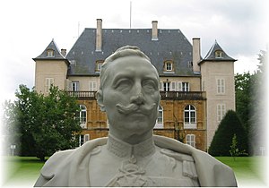
 Urville Castle and Kaiser Wilhelm II. |
||
Courcelles-Chaussy (German Kurzel , 1940 to 1944 Kurzel an der Straße ) is a French commune with 3,075 inhabitants (as of January 1, 2017) in the Moselle department in the Grand Est region (until 2015 Lorraine ).
geography
The municipality of Courcelles-Chaussy is located on the French Nied , 15 kilometers east of Metz .
history
The remains of villas from Roman times can be found on the territory of the municipality . It was formed in the Middle Ages from the two districts Courcelles (mentioned in 1178 as Curcellis, 1448: Kürtzel , 1462: Kortzel , 1542: Courtzell ) and Chaussy (already mentioned around 610 as Calciago , German Kelsch ), which are on both sides of the old Roman road to Metz lay.
In 1552 Courcelles-Chaussy came to France and became a regional center of the Huguenots , who built a reformed church there around 1560. It lasted until 1685, when the Edict of Fontainebleau banned Protestant services in France. After the Edict of Tolerance of 1787, some Protestants returned in 1797 and built a reformed church again.
In 1812 the neighboring village of Pont-à-Chaussy (mentioned in 1270 as Kurtzebrucken , German Kalscherbruck ) was incorporated.
From 1871 to 1918 the place belonged to the German Empire and became known for the Château d'Urville ( Urville Castle or Urweiler ), which was a summer residence of Wilhelm II after renovation and conversion .
In 1973 the neighboring village of Landonvillers ( Landenweiler , 1940 to 1944 Ladenweiler ) was incorporated. It has a baroque castle, which was considerably expanded between 1904 and 1906 according to plans by Bodo Ebhardt , whereby it should be given a medieval character.
Population development
| year | 1962 | 1968 | 1975 | 1982 | 1990 | 1999 | 2007 | 2013 |
| Residents | 1,238 | 1,240 | 1,708 | 2.263 | 2,365 | 2,391 | 2,954 | 3,054 |
Web links
Individual evidence
- ↑ a b c Wolfgang Haubrichs : Warndt Corridor and Metzer Romanenring: Considerations on the settlement-historical and linguistic-historical meaning of the double names and the name change in Lorraine. In: Place name change Bamberger Symposion, 1986, page 269, 272, 280.
- ↑ Bärbel Kuhn, Martina Pitz, Andreas Schorr - "Limits" without subject boundaries: interdisciplinary approaches
- ↑ Eberhard Gresch: The Huguenots. History, Belief and Impact. 4th, revised edition. Evangelische Verlagsanstalt, Leipzig 2009, ISBN 978-3-374-02260-1 , pp. 181-182
- ^ Announcement concerning the change of French outlying town names, dated April 9, 1917. In: Central and District Official Gazette for Alsace-Lorraine, No. 16/1917, pages 353-360.
