Marange-Silvange
| Marange-Silvange | ||
|---|---|---|

|
|
|
| region | Grand Est | |
| Department | Moselle | |
| Arrondissement | Metz | |
| Canton | Rombas | |
| Community association | Pays Orne Moselle | |
| Coordinates | 49 ° 13 ' N , 6 ° 6' E | |
| height | 168-377 m | |
| surface | 15.24 km 2 | |
| Residents | 6,179 (January 1, 2017) | |
| Population density | 405 inhabitants / km 2 | |
| Post Code | 57535 | |
| INSEE code | 57443 | |
| Website | Marange-Silvange | |
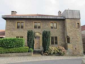
 Château de Marange |
||
Marange-Silvange (German Maringen-Silvingen ) is a French commune with 6,179 inhabitants (as of January 1, 2017) in the Moselle department in the Grand Est region (until 2015 Lorraine ). It belongs to the arrondissement of Metz .
geography
The municipality of Marange-Silvange is twelve kilometers northwest of Metz . Marange, the larger of the two settlements, stretches along a slope above the valley of the Bitteron , a small tributary of the Moselle .
The A4 autoroute ( Paris - Strasbourg ) runs through the south of the municipality .
history
Marange was first mentioned as Madrengias in 971 and has belonged to France since 1659. Silvange came to France in 1766 and the two communities were merged in 1809.
At the beginning of the 20th century, Marange-Silvange developed from a small farming village into a dormitory for the surrounding steelworks and ironworks. Since the decline of the coal and steel industry in the entire region, many residents have been commuting to the surrounding industrial companies between Metz and Thionville and in nearby Luxembourg .
Marange-Silvange was the eponymous main town (chef-lieu) of the canton of Marange-Silvange, which was dissolved that year .
Population development
| year | 1962 | 1968 | 1975 | 1982 | 1990 | 1999 | 2007 | 2017 |
| Residents | 4699 | 5033 | 6510 | 5538 | 5674 | 5402 | 5795 | 6179 |
Town twinning
- Kirn , Germany


