
Hagondange
| Hagondange | ||
|---|---|---|

|
|
|
| region | Grand Est | |
| Department | Moselle | |
| Arrondissement | Metz | |
| Canton | Le Sillon mosellan | |
| Community association | Communauté de communes Rives de Moselle | |
| Coordinates | 49 ° 15 ′ N , 6 ° 10 ′ E | |
| height | 154-209 m | |
| surface | 5.50 km 2 | |
| Residents | 9,242 (January 1, 2017) | |
| Population density | 1,680 inhabitants / km 2 | |
| Post Code | 57300 | |
| INSEE code | 57283 | |
| Website | Hagondange | |
 Hagondange Town Hall |
||

Hagondange (German Hagendingen , Lorraine Hoendéngen ) is a French commune with 9,242 inhabitants (as of January 1, 2017) in the Moselle department in the Grand Est region (before 2016 Lorraine ). It belongs to the arrondissement of Metz .
geography
Hagondange is located on the Moselle , about 13 kilometers south of Thionville on the German side of the former German-French language border . The place is at an altitude between 154 and 209 m above sea level. The municipality covers 5.50 km².
history
The place was first mentioned in 795 as Hagelinga .
At least in the 1960s, there were partnerships with the city of Magdeburg in the GDR for some time .
Population development
| year | 1910 | 1962 | 1968 | 1975 | 1982 | 1990 | 1999 | 2007 | 2015 |
| Residents | 1727 | 11,061 | 10,567 | 10,048 | 9091 | 8222 | 8675 | 9212 | 9281 |
Culture and sights
The Walygator Parc is located in the south of the municipality .
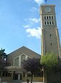
Heart of Mary Church

Saint-Jacques church

reformed Church

former synagogue

Watchtower from the 12th century


railway station
From 1912 to 1964 the Hagendingen tram ran from the train station to steelworks in the region. Hagondange station is on the Metz – Luxemburg and Saint-Hilaire-au-Temple – Hagondange lines .
Web links
Individual evidence
- ^ Alexander Wiltheim - Luxemburgum Romanum
- ↑ Ingelore Buchholz , Maren Ballerstedt, A monument was set up for them , publisher: Landeshauptstadt Magdeburg, Stadtarchiv, 1997, page 46