
Lorry-Mardigny
| Lorry-Mardigny | ||
|---|---|---|

|
|
|
| region | Grand Est | |
| Department | Moselle | |
| Arrondissement | Metz | |
| Canton | Les Coteaux de Moselle | |
| Community association | Mad et Moselle | |
| Coordinates | 48 ° 59 ′ N , 6 ° 5 ′ E | |
| height | 187-396 m | |
| surface | 11.36 km 2 | |
| Residents | 650 (January 1, 2017) | |
| Population density | 57 inhabitants / km 2 | |
| Post Code | 57420 | |
| INSEE code | 57416 | |
| Website | Lorry-Mardigny | |

|
||

Lorry-Mardigny is a French commune with 650 inhabitants (as of January 1, 2017) in the Moselle department in the Grand Est region (until 2015 Lorraine ).
geography
The municipality of Lorry-Mardigny is on the border with the Meurthe-et-Moselle department , about 16 kilometers southeast of Metz and nine kilometers north of Pont-à-Mousson in the hills east of the nearby Moselle valley . The A31 car route running in north-south direction leads through the area of the municipality.
history
The two villages Lorry and Mardigny were merged in 1810 to form the municipality of Lorry-devant-le-Pont (Pont = Pont-à-Mousson), which fell under its current name to the German Empire after the Franco-Prussian War in 1871 . During the First World War , the community was renamed Lorringen-Mardeningen from 1915 to 1918 until it was returned to France in November 1918.
During the Second World War , the village was occupied again by the Germans, who on November 13, 1940, expelled all of the residents , this time renaming it Lörringen-Mardeningen , and until the liberation some German families settled there. The inhabitants of Lorry-Mardignys returned to an almost completely destroyed village in the spring of 1945.
Population development
| year | 1962 | 1968 | 1975 | 1982 | 1990 | 1999 | 2007 | 2015 |
| Residents | 337 | 341 | 347 | 373 | 449 | 490 | 572 | 639 |

Château de Mardigny
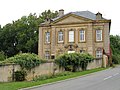
Château de Lorry

Holy Cross Church in Lorry

Notre-Dame-de-la-Salette chapel


