
La Maxe
| La Maxe | ||
|---|---|---|

|
|
|
| region | Grand Est | |
| Department | Moselle | |
| Arrondissement | Metz | |
| Canton | Le Sillon mosellan | |
| Community association | Metz Métropole | |
| Coordinates | 49 ° 10 ′ N , 6 ° 11 ′ E | |
| height | 161-167 m | |
| surface | 7.55 km 2 | |
| Residents | 924 (January 1, 2017) | |
| Population density | 122 inhabitants / km 2 | |
| Post Code | 57140 | |
| INSEE code | 57452 | |

La Maxe is a French commune with 924 inhabitants (as of January 1, 2017) in the Moselle department in the Grand Est region (until 2015 Lorraine ). It belongs to the arrondissement of Metz .
geography
La Maxe is located on the Moselle , seven kilometers north of Metz at an altitude between 161 and 167 m above sea level. The municipality covers 7.55 km².
history
1915–1918 and 1940–1944 it bore the German name Masch .
Population development
| year | 1962 | 1968 | 1975 | 1982 | 1990 | 1999 | 2007 |
| Residents | 449 | 505 | 650 | 691 | 735 | 823 | 837 |
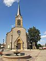
Saint-Baudier church

La Maxe coal-fired power station


Economy and Infrastructure
In the industrial area in the south of the municipality, a coal-fired power station operated by EDF supplies electricity and heat to the nearby city of Metz.
Web links
Commons : La Maxe - collection of images, videos and audio files