Verny
| Verny | ||
|---|---|---|

|
|
|
| region | Grand Est | |
| Department | Moselle | |
| Arrondissement | Metz | |
| Canton | Faulquemont | |
| Community association | Sud Messin | |
| Coordinates | 49 ° 0 ′ N , 6 ° 12 ′ E | |
| height | 172-246 m | |
| surface | 3.90 km 2 | |
| Residents | 1,950 (January 1, 2017) | |
| Population density | 500 inhabitants / km 2 | |
| Post Code | 57420 | |
| INSEE code | 57708 | |
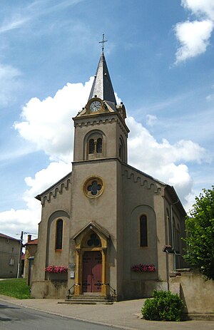
 Saint-Michel church |
||
Verny is a French commune with 1950 inhabitants (as of January 1, 2017) in the Moselle department in the Grand Est region ( Lorraine until 2015 ). It belongs to the arrondissement of Metz and was the main town ( chef-lieu ) of the canton of the same name until 2015 .
geography
The village is about 14 kilometers south of the city of Metz .
history
The place was first mentioned in 914 as Verniacum and was owned by the bishops of Metz in the Middle Ages .
After the Franco-Prussian War , Verny came to the German Empire in 1871 ; Between 1904 and 1910, the Wagner Fortress (now Fort de Verny ) was built on the northern edge of the municipality as part of the military belt of fortifications around Metz . In 1915 the place was renamed Werningen until it was finally returned to France in 1918.
During the Second World War , Verny was occupied by the Germans, who expelled a large part of the population in November 1940; In 1944 the place was badly destroyed during the liberation.
Population development
| year | 1962 | 1968 | 1975 | 1982 | 1990 | 1999 | 2007 | 2017 |
| Residents | 238 | 257 | 1,216 | 1,467 | 1,434 | 1,502 | 1,900 | 1,950 |
