
Siersburg
|
Siersburg
Community Rehlingen-Siersburg
|
||
|---|---|---|
 |
||
| Area : | 9.49 km² | |
| Residents : | 4261 (Dec. 31, 2007) | |
| Population density : | 449 inhabitants / km² | |
| Incorporation : | 1st January 1974 | |
| Postal code : | 66780 | |
| Area code : | 06835 | |
Location of Siersburg in Saarland |
||


Siersburg is a district of the municipality of Rehlingen-Siersburg and the seat of the municipal administration. Siersburg lies on the banks of the Nied , a tributary of the Saar, and is part of the Saarlouis district in Saarland . The place has an area of 949 hectares and 4261 inhabitants (as of December 31, 2007) .
history
Siersburg was created through the merger of the towns of Büren ( Biren ), Itzbach and Siersdorf ( Siirsdroff ) on April 1, 1937. The namesake for the new place was the eponymous castle Siersburg , which was probably built in the 11th century .
Until the end of 1973 Siersburg was an independent municipality. In the course of the territorial and administrative reform , the previously independent municipality of Siersburg became a district of the municipality of Rehlingen on January 1, 1974, which was later renamed Rehlingen-Siersburg.
traffic
The Siersburg stop is on the Niedtalbahn .
Attractions
- Siersburg Castle
- St. Willibrordus Chapel in Siersdorf
- Medieval herb garden in Siersdorf
- Parish Church of St. Martin in Itzbach
- Castle in Itzbach
Castle Festival
Since 1968, the “Burgfest” festival has been held every summer on the Siersburg plateau - mostly in July. The organizer of the castle festival is the Christian Workers' Youth (CAJ) Siersburg.
Maypole Festival
Every year on April 30th The maypole setting that has become tradition takes place on the church square in Siersburg, followed by a maypole festival. This festival is organized by the parish youth (PJ) Siersburg
Location views

Nied bridge view

Chapel of St. Willibrordus by night
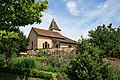
St. Willibrordus Chapel with herb garden in Siersdorf

Partial view of Büren and Itzbach

church
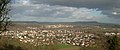
View of Rehlingen

Exterior view

tower


literature
- Guido Müller: The residents of Rehlingen and Siersburg before 1850. Sources for genealogy in the Saarlouis district and adjacent areas Volume 3. Association for local history in the Saarlouis district e. V., self-published
Web links
Individual evidence
- ↑ a b Geoplatt ( Memento of November 13, 2007 in the Internet Archive )
- ^ Federal Statistical Office (ed.): Historical municipality directory for the Federal Republic of Germany. Name, border and key number changes in municipalities, counties and administrative districts from May 27, 1970 to December 31, 1982 . W. Kohlhammer, Stuttgart / Mainz 1983, ISBN 3-17-003263-1 , p. 807 .