Steinwasser (Gadmerwasser)
|
Steinwasser Steiwasser |
||
|
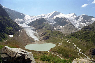
Steinsee with Steinwasser (right) |
||
| Data | ||
| Water code | CH : 713 | |
| location |
Uri Alps
|
|
| River system | Rhine | |
| Drain over | Gadmerwasser → Aare → Rhine → North Sea | |
| Headwaters | at the Steingletscher 46 ° 42 ′ 52 ″ N , 8 ° 26 ′ 7 ″ E |
|
| Source height | approx. 2121.7 m above sea level M. | |
| muzzle | underwater in Gadmer water coordinates: 46 ° 43 '59 " N , 8 ° 23' 3" E ; CH1903: 672 273 / 176 184 46 ° 43 '59 " N , 8 ° 23' 3" O |
|
| Mouth height | approx. 1364 m above sea level M. | |
| Height difference | approx. 757.7 m | |
| Bottom slope | approx. 11% | |
| length | 6.8 km | |
| Catchment area | 24.3 km² | |
| Discharge A Eo : 24.3 km² at the mouth |
MQ Mq |
1.98 m³ / s 81.5 l / (s km²) |
| Right tributaries | Obertalbach, Löibbach | |
| Communities | Innertkirchen | |
|
The stone water at Steinsee on the Susten Pass |
||
The Steinwasser is an approximately 7 kilometers long right tributary of the Gadmerwasser in the Swiss canton of Bern .
geography
course
The stone water rises at Steingletscher near the Sustenpass at an altitude of 2,121.7 meters above sea level. M. .
It receives water from a number of nameless spring streams on its upper course. They arise from the Steilimigletscher and Obertalgletscher as well as the Steinsee and Seebodensee .
The stone water finally flows into Unterwasser at an altitude of about 1364 m above sea level. M. from the right into the Gadmerwasser.
The approximately 6.8 kilometers long course of the Steinwasser ends approximately 758 meters below its source, so it has a mean bed gradient of about 11 ‰.
Catchment area
The Steinwasser catchment area of 24.31 km² is located in the Urner Alps and is drained through it via the Gadmerwasser, the Aare and the Rhine to the North Sea.
It consists of 3.8% planted area , 8.7% agricultural area , 0.9% settlement area and 86.6% unproductive areas.
The area distribution

The highest point is the Sustenhorn at 3502 m above sea level. M. in the southeast of the catchment area. The mean height is 2463.3 m above sea level. M. and the minimum height is 1400 m above sea level. M. .
Main hydrological strand
Direct comparison at the confluence:
| Surname | Length in km | Catchment area in km² | mean discharge in m³ / s |
|---|---|---|---|
| Gadmerwasser | 3.1 | 5.7 | 0.45 |
| Stone water | 6.8 | 24.3 | 1.98 |
The Steinwasser is longer than the Gadmerwasser at the confluence, it has a larger catchment area and a larger mean discharge (MQ). It is thus the main hydrological strand .
Tributaries
- Sustenbach ( right ), 0.8 km
- Obertalbach ( right ) 2.2 km, 3.28 km²
- Umpolbach ( Steiwasser ) ( left ), 4.1 km, 7.53 km²
- Wysse Bach ( right ), 0.8 km
- Miserenbach ( left ), 2.0 km, 1.29 km²
- Löibbach ( right ), 2.0 km, 1.37 km²
Hydrology
At the confluence of the stone water into the Gadmer water, its modeled mean flow rate (MQ) is 1.98 m³ / s. Its discharge regime type is a-glaciaire and its discharge variability is 13.

Web links
- Course of the stone water on the Geoportal Bern
- Course of the stone water on the geoserver of the Swiss federal administration ( information )
Individual evidence
- ↑ a b c Geoserver of the Swiss Federal Administration ( information )
- ↑ Water network in the WebGis geographic information system of the canton of Bern
- ↑ Topographical catchment areas of Swiss waters: sub-catchment areas 2 km². Retrieved January 25, 2020 .
- ↑ Topographical catchment areas of Swiss waters: Steinwasser , Federal Office for the Environment FOEN
- ↑ Empties into the Steisee
- ↑ It is also seen by some as the upper reaches of the Steinwasser
- ↑ "Hidden behind the mean values" - the variability of the discharge regime , p. 7
- ↑ The discharge variability describes the extent of the fluctuations in the mean discharge of individual years around the long-term mean discharge value.
- ↑ Average discharge and discharge regime type for the Swiss water network: Steinwasser , Federal Office for the Environment FOEN


