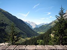
Gadmertal
The Gadmertal (also Gadmental ) is a valley between the Susten Pass in the east and Innertkirchen in the west, in the Bernese Oberland .
geography
The Gadmertal is traversed by the Gadmerwasser , which flows into the Aare from the east near Innertkirchen ( Haslital ) . The Gadmer water, in turn, is mainly fed by the Wenden water, which originates mainly from the Wenden glacier directly below the Titlis in the north and the Fünffingerstöcken ( 2994 m above sea level ) in the south, and from the Steinwasser flowing south of the Fünffingerstocks , which arises from the Steinsee below the Susten Pass . The Steinsee, in turn, is fed by the Steingletscher , located further south , which is framed in a crescent shape by the Sustenhorn ( 3502 m ), the Vorder Sustenlimihorn ( 3315 m ), the Rotstock ( 3184 m ) and the Gwächtenhorn ( 3404 m ).
Around 330 people live in the settlements in Gadmertal; the larger towns from east to west are: Gadmen , Fuhren , Nessental , Hopflauenen and Wyler directly above Innertkirchen.
Side valleys
The main side valley is the Gental , which is located to the north, but runs almost parallel , which is separated from the Gadmertal by the Gadmerflue and only meets the Gadmertal shortly before Innertkirchen and feeds its Gental water into the Gadmerwasser. The Tällibahn cable car from Kraftwerke Oberhasli AG runs between Gadmen and Oberfuhren on the north side of the valley to the mountain station ( 1714 m ) below the Tällihütte ( 1726 m ) in the Birchlaui directly below the Tällistock ( 2580 m ).
The Trift Gorge, which is cut through the Trift water in about the middle of the Gadmer Valley and coming at right angles from the south, is striking . At the beginning, the Trift Gorge is spanned by the Trift Bridge, one of the longest and highest pedestrian suspension bridges in the Alps, which offers an uninterrupted view of the Triftsee ( 1716 m ) and the Trift Glacier in the south. The Triftbahn leads from the Schwendeli in the valley to the Unteri Trift mountain station ( 1390 m ), from where you can get to the Trift bridge at Triftsee and the Windegghütte ( 1887 m ), or further to the Triftütte ( 2520 m ) further south, or over the Windegg and the Furtwangsattel ( 2568 m ) in the west to Guttannen back into the Haslital.
Audio book
- Fred Jaggi: Gadmertal - Gschicht u Gschichti , Zytglogge Verlag, Basel 2007.
Web links
Individual evidence
- ↑ Skiclub Gadmental and Volkswirtschaft Berner Oberland ( Memento of the original from May 29, 2016 in the Internet Archive ) Info: The archive link has been inserted automatically and has not yet been checked. Please check the original and archive link according to the instructions and then remove this notice.
Coordinates: 46 ° 44 ′ 20 " N , 8 ° 21 ′ 7" E ; CH1903: 669804 / 176 829

