
Drift water
| Drift water | ||
 Drift water in the lower section |
||
| Data | ||
| Water code | CH : 1891 | |
| location |
Uri Alps
|
|
| River system | Rhine | |
| Drain over | Gadmerwasser → Aare → Rhine → North Sea | |
| source | above the Triftsee 46 ° 40 ′ 58 ″ N , 8 ° 21 ′ 39 ″ E |
|
| Source height | approx. 1700 m above sea level M. | |
| muzzle | before Nessental into Gadmerwasser Coordinates: 46 ° 43 ′ 13 " N , 8 ° 18 ′ 16" E ; CH1903: 666 202 / 174 719 46 ° 43 '13 " N , 8 ° 18' 16" O |
|
| Mouth height | 925 m above sea level M. | |
| Height difference | approx. 775 m | |
| Bottom slope | approx. 76 ‰ | |
| length | 10.2 km | |
| Catchment area | 45.96 km² | |
| Discharge A Eo : 45.96 km² at the mouth |
MQ Mq |
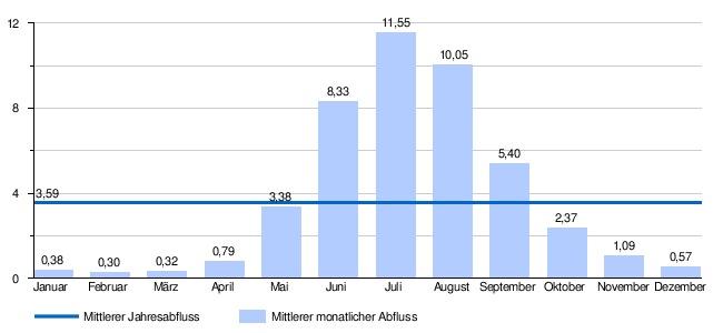
3.59 m³ / s 78.1 l / (s km²) |
The Triftwasser is an approximately 10 kilometer long tributary of the Gadmerwasser in the Oberhasli in the canton of Bern in Switzerland .
geography
course
The wild river rises below the Trift glacier on the north side of the Winterberg massif and initially flows through the Triftsee at around 1660 m above sea level. M. , a natural lake near the border with the canton of Uri .
Around 2400 meters after the lake drains, the water is collected and used to produce electricity. The operator of the power plant is the regional company Kraftwerke Oberhasli (KWO).
After the Triftwasser flows into the Gadmerwasser , it reaches the Aare near Innertkirchen after a further 7 kilometers .
Catchment area
The 45.96 km² catchment area of the Triftwasser is drained through it via the Gadmerwasser, the Aare and the Rhine to the North Sea.
It consists of 7.3% planted area , 2.4% agricultural area , 0.2% settlement area and 90.1% unproductive areas.
The area distribution

The mean height of the catchment area is 2436.4 m above sea level. M. , the minimum height is 930 m above sea level. M. and the maximum height at 3473 m above sea level. M.
Tributaries
- Tällibach ( left ), 3.4 km, 4.24 km²
- Drosibach ( right ), 2.6 km, 3.52 km²
- Graaggi Graben ( right ), 1.6 km, 1.54 km²
- Trosligwan moat ( left ), 0.4 miles
- Radlefsgraben ( right ), 0.8 km
- Triftgräbli ( right ), 0.4 km
- Tobiger ( left ), 2.1 km, 1.26 km²
- Lenggraben ( left ), 1.2 km
- Tannelengraben ( left ), 1.1 km
- Bees Gräbli ( left ), 0.9 km
- Bees Graben ( right ), 0.9 km
- Horigraben ( right ), 0.8 km
- Horiwang ( right ), 0.4 km
- Indre Erggeligraben ( left ). 0.8 km, 0.86 km²
- Üssere Erggeligraben ( left ). 0.5 km
- Bidmibächli ( left ), 0.2 km
- Blattengraben ( left ), 1.9 km
Hydrology
At the confluence of the Trift water in the Gadmer water, its modeled mean flow rate (MQ) is 3.59 m³ / s. Its discharge regime type is a-glaciaire and its discharge variability is 13.
Web links
- Course of the Trift water on the Geoportal Bern
- Course of the drift water on the geoserver of the Swiss federal administration ( information )
- More information about the Triftwasser
Individual evidence
- ↑ a b c Geoserver of the Swiss Federal Administration ( information )
- ↑ a b Topographical catchment areas of Swiss waters: sub-catchment areas 2 km². Retrieved January 25, 2020 .
- ↑ Water catchment area of the KWO (PDF; 1.4 MB) ( page no longer available , search in web archives ) Info: The link was automatically marked as defective. Please check the link according to the instructions and then remove this notice. , accessed January 26, 2014
- ↑ Topographic catchment areas of Swiss waters: Triftwasser , Federal Office for the Environment FOEN
- ↑ "Hidden behind the mean values" - the variability of the discharge regime , p. 7
- ↑ The discharge variability describes the extent of the fluctuations in the mean discharge of individual years around the long-term mean discharge value.
- ↑ Average discharge and discharge regime type for the Swiss water network: Triftwasser , Federal Office for the Environment FOEN