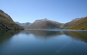
Lai da Sontga Maria
| Lai da Sontga Maria | |||||||
|---|---|---|---|---|---|---|---|
| Lai da Sontga Maria | |||||||
|
|||||||
|
|
|||||||
| Coordinates | 704036 / 159091 | ||||||
| Data on the structure | |||||||
| Lock type: | Arch dam | ||||||
| Construction time: | until 1968 | ||||||
| Height of the barrier structure : | 117 m | ||||||
| Height above the river bed : | 86 m | ||||||
| Building volume: | 654,000 m³ | ||||||
| Crown length: | 560 m | ||||||
| Crown width: | 8 m | ||||||
| Base width: | 21 m | ||||||
| Operator: | Kraftwerke Vorderrhein AG, Ovra Electrica Rein Anteriur SA | ||||||
| Data on the reservoir | |||||||
| Altitude (at congestion destination ) | 1908 m | ||||||
| Water surface | 1.77 km² | ||||||
| Reservoir length | 3.0 | ||||||
| Storage space | 67.3 million km³ | ||||||
| Catchment area | 27.1 | ||||||
| Design flood : | 150 m³ / s | ||||||
The Lai da Sontga Maria ( , Italian. Lago di Santa Maria ) is a Swiss reservoir on the Lukmanier Pass in the area of the municipality of Medel (Lucmagn) in the canton of Graubünden .
The 117 m high Santa Maria arch dam of the Vorderrhein power plant was completed in 1968. At the top of the wall, which is 560 m long, the wall is 8 m wide, at the foot it measures 21 m.
The Rein da Medel / Reno di Medel is captured in the reservoir with a volume of 67.3 million m³ . In addition to other natural tributaries, there is also an approximately 5500 m long gravity tunnel that feeds water from the Val Uffiern to the east. The filled lake has a length of 3 kilometers and a surface of 177 hectares .
The lake is connected to the Lai da Nalps reservoir to the northwest in a neighboring valley by a pressure tunnel around 8,800 m long . Together with this and the Lai da Curnera further to the west, it forms a water management system connected by pipes with a useful volume of 152 million m³, which is used to generate peak electricity. The three lakes are almost at the same height. Electricity generation is in a cavern lying powerhouse Sedrun the power plants Vorderrhein place and a subsequent power plant level.
The construction of the Gotthard base tunnel for the NEAT in the immediate vicinity of the three reservoirs means that all three dams are monitored with sensors for safety reasons. A simultaneous rupture of all three dams could completely flood the village of Disentis and all the communities below (such as Ilanz , Chur ) due to the tidal waves arriving in the Vorderrheintal almost at the same time .
In the lake there is a guy mast of the Lukmanier line . There is a Sunrise / Orange / Swisscom mobile phone location on the dam.


