
Medel (Lucmagn)
| Medel (Lucmagn) | |
|---|---|
 |
|
| State : |
|
| Canton : |
|
| Region : | Surselva |
| BFS no. : | 3983 |
| Postal code : | 7184 and 7185 |
| Coordinates : | 706 795 / 165 624 |
| Height : | 1332 m above sea level M. |
| Height range : | 1090–3207 m above sea level M. |
| Area : | 136.22 km² |
| Residents: | 362 (December 31, 2018) |
| Population density : | 3 inhabitants per km² |
| Website: | www.medel.ch |
 Curaglia |
|
| Location of the municipality | |
 _2018.png) |
|
Medel (Lucmagn) ( , German and officially Medels in the Oberland until 1943 ) is a municipality in the Surselva region of the canton of Graubünden in Switzerland .
coat of arms
Blazon : Saint Martin in silver (white) on a black horse , sharing the red cloak with the beggar
Saint Martin is the patron saint of the parish church and was already depicted in the parish seal.
geography

The municipality includes all localities in Val Medel , the valley between Disentis / Mustér and the Lukmanier Pass . Its southern border is also the cantonal border between Graubünden and Ticino. Medel (Lucmagn) therefore includes numerous villages, hamlets and isolated settlements. The former center was Platta ( 1389 m above sea level ) - the small, avalanche-prone settlement is still called the main town today. The largest village today is Curaglia . Other main settlements in the extensive community are (from north to south) Soliva ( 1492 m ), Mutschnengia ( 1405 m ), Fadretsch ( 1278 m ), Baselgia ( 1365 m ), Drual ( 1412 m ), Matergia ( 1415 m ), Pardé ( 1400 m ), Fuorns ( 1488 m ), Acla ( 1477 m ) and Sogn Gions ( 1623 m ).
Of the entire municipal area of over 136 km², over 90 km² are unproductive areas, mostly mountains. The highest points are the Piz Medel ( 3210 m ), covered by the Medelser glacier , and the Scopí ( 3190 m ). The Lai da Sontga Maria reservoir on the Lukmanier Pass is 177 hectares in size. A further 2026 hectares are covered by forest and wood. The agricultural area of 2421 ha consists of 2072 ha of Maiensässen and 349 ha of arable and meadow land. The remaining 80 hectares of the municipality are settled.
Because of the gold deposits in the area, various projects have been launched again and again. Gold panning in the Medelser Rhine has been part of the leisure time entertainment of the Disentis Hotel Acla da Fontauna since at least 1985 . The Swiss gold exploration AG is planning a commercial mining. On April 1, 2012, the community's electorate clearly refused to transfer powers in the matter of prospecting licenses to the community board. Thus, the granting of a concession remains a matter for the voters, who obviously value the preservation of an intact landscape very highly.
The area should also become part of the Parc Adula National Park.
population
| Population development | ||||||||||
|---|---|---|---|---|---|---|---|---|---|---|
| year | 1850 | 1900 | 1950 | 1960 | 2000 | 2004 | 2010 | 2012 | 2014 | 2016 |
| Residents | 609 | 536 | 614 | 835 | 470 | 480 | 435 | 422 | 398 | 385 |
Of the 480 residents at the end of 2004, 476 were Swiss nationals. The majority of the population speaks Sursilvan and is Catholic. Some hamlets ( Mutschnengia , Soliva ) were probably in the 14./15. Settled by German-speaking Walsers in the 19th century .
Curaglia has around 300 inhabitants. Ten people live in Drual and four in Matergia. Around 40 people live in Pardé and around 50 people in Fuorns. Acla - formerly the last settlement in the valley - has not been inhabited all year round since an avalanche on April 6, 1975.
Attractions
- Catholic Church of St. Nicholas, in the Curaglia district
- Catholic parish church St. Martin, in the district of Platta
- Chapel of St. Roch Pardé in the district Pardé with paintings of the painter Hans Ardüser
- Chapel of St. Sebastian, in the Mutschnengia district
- Chapel of St. Maria, on the Lukmanier Pass
- St. Gallus Chapel, in the Sogn Gagl district
- Private house with fresco by the painter Antonio da Tradate (1510) in the Curaglia district
- Ziegenalp Puzzetta, 2005, in the district of Fuorns , architects: Marlene Gujan , Conrad Pally
photos
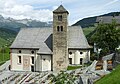
St. Martin Platta Church
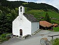
Chapel of St. Rochus Pardé

Curaglia March 2011

The mouth of the Val Plattas side valley below Curaglia looking west - on the far left in the picture Mutschnengia
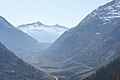
Southern section of the valley with a view of the dam


.JPG)
.JPG)

literature
- The municipalities of the canton of Graubünden. Chur / Zurich, 2003, ISBN 3-7253-0741-5
- Adolf Collenberg: Medel (Lucmagn). In: Historical Lexicon of Switzerland . 2008 .
Web links
- Medel (Lucmagn) on the ETHorama platform
- Official website of the municipality of Medel (Lucmagn)
- Curaglia at ethorama.library.ethz.ch/de/node
- Renzo Dionigi: Platta, Saint Martin Church, frescoes
Individual evidence
- ↑ Permanent and non-permanent resident population by year, canton, district, municipality, population type and gender (permanent resident population). In: bfs. admin.ch . Federal Statistical Office (FSO), August 31, 2019, accessed on December 22, 2019 .
- ↑ a b settlements. (No longer available online.) In: Vischnaunca Medel / Lucmagn. Archived from the original on March 27, 2012 ; Retrieved May 9, 2012 . Info: The archive link was inserted automatically and has not yet been checked. Please check the original and archive link according to the instructions and then remove this notice.
- ↑ Finanz und Wirtschaft ( page no longer available , search in web archives ) Info: The link was automatically marked as defective. Please check the link according to the instructions and then remove this notice.
- ↑ Catholic Church of St. Nicholas
- ^ Catholic parish church of St. Martin
- ↑ St. Sebastian Chapel
- ↑ St. Mary's Chapel
- ↑ St. Gallus Chapel
- ↑ Antonio da Tradate: Crucifixion with Saints Katarina and Luzia (photo)
- ↑ Goat Alp Puzzetta
Breil / Brigels | Disentis / Mustér | Falera | Ilanz / Glion | Laax | Lumnezia | Medel (Lucmagn) | Obersaxen Mundaun | Safiental | Sagogn | Schluein | Sumvitg | Trun | Tujetsch | Vals
Former parishes: Andiast | Camuns | Castrisch | Cumbel | Sword | Duvin | Flond | Ilanz | Ladir | Lumbar clean | Luff | Morissen | Mundaun | Obersaxen | Peiden | Pigniu | Pitasch | Riein | Rueun | Ruschein | Safien | Slim | Schnaus | Sculms | Sevgein | Siat | St. Martin | Strada | Suraua | Surcasti | Surcuolm | Tenna | Tersnaus | Uors | Uors-Peiden | Valendas | Vella | Versam | Vignogn | Vrin | Waltensburg / Vuorz
Canton of Graubünden | Regions of the Canton of Graubünden | Municipalities of the Canton of Graubünden