Intoxication
| Intoxication | ||
|---|---|---|
| State : |
|
|
| Canton : |
|
|
| Region : | Surselva | |
| Political community : | Ilanz / Glion | |
| Postal code : | 7154 | |
| former BFS no. : | 3580 | |
| Coordinates : | 733 721 / 183251 | |
| Height : | 1155 m above sea level M. | |
| Area : | 12.56 km² | |
| Residents: | 334 (December 31, 2013) | |
| Population density : | 27 inhabitants per km² | |
| Website: | Ruschein at www.ilanz-glion.ch | |
|
Intoxication |
||
| map | ||
|
|
||
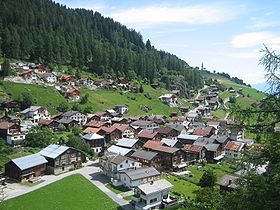
Ruschein ( ) is a village in the Surselva . Until December 31, 2013 it formed a political municipality near Ilanz in what was then the Surselva district of the canton of Graubünden in Switzerland . On January 1, 2014, Ruschein merged with the former municipalities of Castrisch , Duvin , Ilanz , Ladir , Luven , Pigniu , Pitasch , Riein , Rueun , Schnaus , Sevgein , Siat to form the new municipality of Ilanz / Glion .
coat of arms
Blazon : in blue the golden (yellow) Saint George with a silver (white) halo on a jumping white horse, killing the golden dragon
Adoption of the seal motif in the municipal coat of arms .
geography
The Ruschein is located on a terrace north of Ilanz on the left side of the Vorderrhein . The village of Ladir is located about one kilometer northeast of Ruschein . The settlements have grown together through new building quarters.
The former municipal areas of Ruschein and Ladir lay as narrow strips on the mountain slope between the town of Ilanz and the ridge on the Bündner Vorab and the Vorab Pign with the small remainder of the Vorab glacier at about 3000 m above sea level. Most of the head of the valley in the north of Val Siat , where some of the source streams of the Ual da Mulin arise, with the Alp da Ruschein and the high mountain pasture Plaun Grond, lay on Ruscheiner Boden. From the Alp da Ruschein a steep path leads over the Fuorcla da Sagogn , in German Sagenser Furka, into the Alp area Vorab.
Halfway between the village of Ruschein and the Ruscheiner Alp is the Maiensäss Alp Dado , and further up in the valley is the Maiensäss Tarschinas .
Of the former Ruscheiner municipality area of 1254 hectares, 540 hectares were agriculturally usable, 445 hectares, however, only as alpine pastures. In line with the mountainous character of the landscape, there was also 354 hectares of unproductive area. Forest and wood cover a further 323 hectares of the municipal ban; the remaining 37 hectares were settlement areas.
On the territory of Ruschein, southwest of the village, there is the special forest reserve Plontabuora on a hill , on which the ruins of Frauenberg Castle stand.
history
Bronze Age remains have been detected on a rock ridge made of Verrucano (rock, Permian ), the "Crest da Ruschein", also "Pagraph da Buora" (or transformed to "Plontabuora") in the west of Ruschein .
In the upcoming Verrucanofels on the hilltop, numerous larger and smaller bowls were incorporated (scaluttas d'unfrenda). During excavations in 1965, a 19 cm long bronze needle, various pottery shards and wall remains from a settlement from around 1500 to 1200 BC were found. Found. To the west of the throat ditch of the castle ruins is the "altar stone". On the south-facing slope there are other processed rock humps, such as the mysterious "oracle stone". The Ruina da Frundsberg Foundation organizes regular guided tours over the entire ridge in summer.
population
| Population development | |||||||
|---|---|---|---|---|---|---|---|
| year | 1850 | 1900 | 1950 | 1980 | 2000 | 2004 | 2013 |
| Residents | 245 | 277 | 309 | 283 | 356 | 356 | 334 |
Of the 356 residents, 341 were Swiss citizens (end of 2004). It is Sursilvan spoken.
Attractions
The Antonius Chapel.
Personalities
- Matthias Schgier (1622–1687), dean of the cathedral in Chur
- Corina Casanova (* 1956), Swiss Chancellor
- Georges Darms (* 1946), Romansh writer
literature
- The municipalities of the canton of Graubünden. Rüegger, Chur / Zurich 2003, ISBN 3-7253-0741-5 .
- Adolf Collenberg: Ruschein. In: Historical Lexicon of Switzerland . 2016 .
Web links
- Official website of the municipality of Ilanz-Gion
- Adolf Collenberg: Ruschein. In: Historical Lexicon of Switzerland


