
Lumbar clean
| Lumbar clean | ||
|---|---|---|
 |
||
| State : |
|
|
| Canton : |
|
|
| Region : | Surselva | |
| Political community : | Lumnezia | |
| Postal code : | 7148 | |
| former BFS no. : | 3595 | |
| Coordinates : | 729 644 / 171 633 | |
| Height : | 1405 m above sea level M. | |
| Area : | 37.86 km² | |
| Residents: | 361 (December 31, 2012) | |
| Population density : | 10 inhabitants per km² | |
| Website: | www.lumnezia.ch | |
 Lumbar clean |
||
| map | ||
|
||


Lumbrein ( ) is a village in the municipality of Lumnezia , Canton of Graubünden , Switzerland . The village is located in the Val Lumnezia (Lugnez), around 15 km from Ilanz . The hamlets on the south side of the Glenner are called Surin and Silgin .
By the end of 2012 Lumbrein formed its own political municipality . On January 1, 2013, it merged with the municipalities of Cumbel , Degen , Morissen , Suraua , Vignogn , Vella and Vrin to form the new municipality of Lumnezia.
coat of arms
Blazon : A silver (white) wave pole in green.
The coat of arms represents the division of the formerly independent municipality by the river Glenner . It is derived from the coat of arms of the Lords of Lumerins , whose castle tower still exists in the village.
Population and language
| Population development | ||||||
|---|---|---|---|---|---|---|
| year | 1850 | 1900 | 1930 | 1950 | 2000 | 2012 |
| Residents | 529 | 531 | 475 | 584 | 399 | 361 |
Around 90 percent of the population speak Romansh . The changes in the population structure and the economic and social situation have a very strong influence on the Romansh-speaking minority, coupled with other influences of modernity such as the omnipresent German-speaking media. A crisis in agriculture from 1950 to 1970 reduced u. a. the population of the former municipality by a quarter. Around 1960 began a strong migration of Rhaeto-Romans to the economically strong centers of the Swiss plateau. The immigration of German-speaking second home owners and the influences of the accompanying tourism allowed the population to stabilize at times. However, a reduction in the birth rate and similar structural problems as in the rest of Lugnez led to a merger with other neighborhoods from 2016 onwards and to the single municipality of Lumnezia, which was funded by the cantonal authorities .
history
The name Lumbrein appears for the first time in 830 as arable in ville Lamarine in the imperial empire (copy from the 16th century). The origin and meaning of the name are very uncertain.
The oldest settlement in the municipality is around 1500 BC. Hill settlement Crestaulta near the hamlet of Surin. The archaeological finds made there, which can be seen today in the Rhaetian Museum in Chur, point to a long history of settlement. In 1961 a stele with an anthropomorphic representation of people was found southwest of Lumbrein in Sietschen . Based on comparable steles from northern Italy, Italian researchers dated it to the late Neolithic . Traces of historical mining at the exit of the Val Miedra testify to the unsuccessful efforts to mine natural resources. A large number of former residents who left the mountain village in order to establish an existence abroad is well documented. A common family name in Lumbrein is the Capaul family .
In the early Middle Ages the village was a Frankish imperial estate. The Walser and Blenieser (residents of the Blenio Valley ) who moved here in the late Middle Ages settled mainly on the right bank of the Glenner and were Romanised. There were frequent disputes over rights of use between their farms and the residents to the right of the Glogn / Glenner. Around 1350 Lumbrein belonged to the Bailiwick of the Lords of Belmont , after 1371 to the Lords of Lumbrein. From 1390, as in the neighboring towns, barons von Sax appeared as landlords. This was probably with the intention of controlling the pass connections to the south via the Valserberg and Greina .
From 1395 Lumbrein is documented as a member of the Lugnez judicial community. In 1538 the episcopal rights - similar to the surrounding towns - were bought out. The Church of St. Martin was a branch church of the Catholic Church Pleif in Vella . In 1646, today's parish church, which was first opened in 1345, was rebuilt in the baroque style. Lumbrein became known for his annual processions at the Kirchweih festival (Romanesque: Pardanonza ) in October.
Lumbrein was a traditional farming village in the last century, but the number of farms fell sharply from the 1950s. This was also associated with a decline in the population and strong emigration. In 1976–2005 there was an overall improvement in mountain agriculture, which is strongly characterized by the Alps . A strong mechanization and modernization of the farms followed. Around 1970 tourism started to a modest extent, which is still a main source of income for many residents.
Lumbrein has its own small power plant and thus its own energy supply. The high solar radiation in the Lugnez also favors the energy supply by means of solar energy, which was strongly promoted in the valley. A planned wind farm in the alpine area of Staviala vedra and in the Val Cavel is controversial and has been put on hold because of protests by nature and landscape protection . A power plant project was also prevented by nature conservation groups, which provided for the still free-flowing valley river Glenner and its side streams for energy supply. At the foot of the Glenner there is a private fish farm with the aim of strengthening local mountain farming by means of a new line of business.
Sights and tourist hotspots
Lumbrein was included in the inventory of places worthy of protection in Switzerland because of its compact village appearance and the well-preserved historical buildings .
Worth seeing:
- The Bronze Age settlement of Crestaulta
- Baroque parish church of St. Martin
- Chapel of St. Andrew
- Sogn Roc Chapel (Lumbrein)
- Chisti residential tower
- Casaulta residential tower
- Wooden bridge over the Glogn / Glenner, which connects Lumbrein and Silgin
- Casa d'Angel (village museum and cultural center in the old parish building with a crystal find worth seeing)
- Maiensäss landscape on the foothills of Piz Sezner
- Ski touring area on the Umsu and in the Val Cavel
Personalities
- James Caviezel (* 1968), actor - his grandfather, who emigrated to America, came from Lumbrein
- Armin Capaul , mountain farmer and initiator of the Federal People's Initiative "For the dignity of farm animals (horned cow initiative)"
- Gion Bistgaun Capaul (1841–1917), local politician in Graubünden
- Giachen Giusep Casaulta (1919–1995), local politician in Graubünden
- Clara Capaul-Hunkeler (1926-2010). Dentist and head of the Capauliana Art Foundation
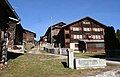
Lumbar wooden houses
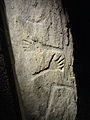
Stele from Sietschen
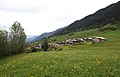
The hamlet of Surin
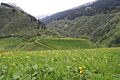
Crestaulta Hill
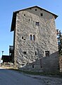
Casaulta residential tower from the 14th century


literature
- Duri Blumenthal et al. a .: Cultural guide Val Lumnezia and Vals. Vella 2000, pp. 164-80.
- Curdin Capol: Romansh and Romanism in Graubünden. Study on the state and future of the Romansh: Contribution to the protection of alpine cultural and linguistic areas. Wil 2010.
- Hans Jenny: Art guide through Switzerland. 5th edition. Wabern 1971, p. 244 f.
- Jürg Rageth, Adolf Collenberg: Lumbrein. In: Historical Lexicon of Switzerland . 2017 .
- Willy Zeller: Art and culture in Graubünden. 2nd edition, Bern 1976, p. 72.
Web links
- Out and about in Lugnez: Small guide through the Val Lumnezia .
- Community link Lumbrein
- Castle world: Casti da Lumbrein (Chisti)
- Castle world: Casaulta
- Controversial wind farm project
- Local museum Casa d'Angel
- Capauliana Foundation
- Val Lumnezia
- Graubünden culture
- Val Lumnezia . In: Lexicon Istoric Retic (Rhaeto-Romanic)
Individual evidence
- ↑ Lexicon of Swiss municipality names . Edited by the Center de Dialectologie at the University of Neuchâtel under the direction of Andres Kristol. Frauenfeld / Lausanne 2005, p. 550.
Breil / Brigels | Disentis / Mustér | Falera | Ilanz / Glion | Laax | Lumnezia | Medel (Lucmagn) | Obersaxen Mundaun | Safiental | Sagogn | Schluein | Sumvitg | Trun | Tujetsch | Vals
Former parishes: Andiast | Camuns | Castrisch | Cumbel | Sword | Duvin | Flond | Ilanz | Ladir | Lumbar clean | Luff | Morissen | Mundaun | Obersaxen | Peiden | Pigniu | Pitasch | Riein | Rueun | Ruschein | Safien | Slim | Schnaus | Sculms | Sevgein | Siat | St. Martin | Strada | Suraua | Surcasti | Surcuolm | Tenna | Tersnaus | Uors | Uors-Peiden | Valendas | Vella | Versam | Vignogn | Vrin | Waltensburg / Vuorz
Canton of Graubünden | Regions of the Canton of Graubünden | Municipalities of the Canton of Graubünden