
Duvin
| Duvin | ||
|---|---|---|
 |
||
| State : |
|
|
| Canton : |
|
|
| Region : | Surselva | |
| Political community : | Ilanz / Glion | |
| Postal code : | 7112 | |
| former BFS no. : | 3593 | |
| Coordinates : | 735 577 / 175 256 | |
| Height : | 1180 m above sea level M. | |
| Area : | 17.93 km² | |
| Residents: | 83 (December 31, 2013) | |
| Population density : | 5 inhabitants per km² | |
| Website: | www.ilanz-glion.ch/fraktionen/luven.html | |
 Duvin |
||
| map | ||
|
||


Duvin (German Duvin , advises. Duin ) is a village belonging to the municipality of Ilanz / Glion in the lower Val Lumnezia (Lugnez), Canton of Graubünden , Switzerland .
Until the end of 2013, it formed an independent political municipality . On January 1, 2014 Duvin merged with the previously independent municipalities of Castrisch , Ilanz , Ladir , Luven , Pigniu , Pitasch , Riein , Rueun , Ruschein , Schnaus , Sevgein and Siat to form the new municipality of Ilanz / Glion.
geography
From Duvin, which is located on a meadow terrace, you have a view of the whole of Lugnez. Located on the right side of the valley, the Pitascher Tobel separates the villages of Duvin from Pitasch. Across from Duvin is Camuns on a mild sun terrace . Both places are separated by a deeply cut slate called Val Uastg ( Val is the Romansh word for "valley", "gorge" or "gorge", Uastg is a proper name). There was no real traffic connection on the right side of the Glenner valley until 1850. The inhabitants of Duvin only had a secure road connection over the Glenner Bridge near Peiden into Lugnez and then to Ilanz after the expansion of the Valser Talstrasse in the 19th century . For centuries, the schisty mountain tobos could only be crossed with great effort and structurally isolated the mountain villages. However, important cattle and mule tracks have always led from Duvin and Pitasch over the Güner Lückli . In 1935 an alpine road was opened on the left side of the ravine of Val Uastg to Alp Radun and the Maiensässen, which made alpine farming easier. The village is now administratively part of Ilanz and has good transport links with a post bus line. The panorama from Duvin covers the whole of Lugnez up to the Gruob.
180 hectares of cultivated land, 755 hectares of pastures, 530 hectares of forest and 332 hectares of unproductive land (mostly mountainous areas) were of the former 1797 hectares of the municipal area.
Duvin was politically bordered until December 31, 2013, when it gave up its independence as a community, in the east on Safien , in the north on Pitasch , in the northwest on Cumbel and in the south and southwest on Suraua .
history
During excavations on a hill in the immediate vicinity of the village, graves were found which prove that Duvin was already settled in pre-Christian times. Around the year 840 AD Duvin was first mentioned in a document as the settlement Auna . In 1290 Duvin (Aiuns) was mentioned in connection with two fiefdoms of the bishop of Chur. In the 14th century the village was a bailiwick of the Barons von Belmont , around 1390 the Counts of Sax-Misox . The introduction of the Reformation took place in 1526. In modern times, the mountain farming village had to struggle again and again with the fluctuations in population development. A large number of residents emigrated due to a lack of income opportunities.
The origin and meaning of the name Duvin are unknown. The current form of the name starting with D is found for the first time in 1466; it is an established connection of the preposition dē «from» or ad «to» with the original form Auna, Awun or similar.
Duvin legend
A legend with reference to the Pietà in the Church of St. Luzius (Peiden) wants to explain why Duvin, as a predominantly Catholic community in Lugnez, switched to the Protestant faith. When the entire Duvin population was in a procession in Vrin around 1600 , it began to rain and all the farmers' hay became wet and therefore bad. Out of anger about it, the Duvinians returned to their village. They threw the statue of Mary they carried over the rock into the abyss. Residents of the neighboring municipality of Peiden hid the statue. The ring finder as well as the little finger of the right hand of the statue of Mary had broken off. The other three fingers were raised in an oath hand. The statue said: "Duvin will burn down twice and the third time the village will fall into the ravine!" Twice the village has burned down almost completely. According to the legend, the next time it should fall into the Val Uastg. However, due to its negative prophecy, the legend probably originated outside of Duvin. The condition of the Pietà also makes the described fall unlikely.
population
| Population development | ||||||
|---|---|---|---|---|---|---|
| year | 1850 | 1900 | 1950 | 1990 | 2000 | 2013 |
| Residents | 105 | 82 | 126 | 80 | 80 | 83 |
Romansh (Sursilvan) is the main language of the village population, the majority of whom work in mountain agriculture.
Duvin, Pitasch and Riein are the only Reformed villages in the otherwise mostly Catholic valley of Lugnez. Before all these places (neighborhoods) joined the community of Ilanz / Glion, Duvin was the only Reformed village in the then Lumnezia / Lugnez district . The reformed parish of Duvin is independent. She is part of the Luven / Flond / Pitasch / Duvin pastoral community. Pitasch and Riein belonged politically to the Ilanz district despite their geographical affiliation to Lugnez . Since 2016 they have been part of the newly formed Surselva region , which replaced the counties and districts.
education
There is a small comprehensive school for the first to sixth grade (together with the neighboring municipality of Pitasch ). The pupils then visit the Real or Secondary School in Ilanz . The school language is Romansh; German is introduced as the first foreign language in the fourth grade.
Transport, economy and tourism
There is a Postbus connection with a change in Mulin da Pitasch (stop on the Postbus route from Ilanz to Vals GR ). You can also continue to Peiden-Bad and walk up to Duvin for about 1 hour.
A carpenter's shop and earning opportunities in the nearby center of Ilanz offer, in addition to tourism and the construction of second homes, isolated earning opportunities. Duvin is the starting point for the pass hike over the Güner Lückli (2470 m, 9.2865 ° E, 46.7092 ° N) to Safien- Platz or Thalkirch. It used to be the first of the three crossings (Güner Lückli, Safierberg , Splügenpass ) on the way from the Vorderrhein to Chiavenna , for which the old Grisons needed 17 hours. There are no inns that are open all year round today, but there are holiday apartments or second homes for rent. At the last farm on the left on Dorfstrasse (in a south-easterly direction; Sumvitg) there is a refreshment bar («Besenbeiz») and, on request, overnight accommodation (sleeping on straw).
Attractions
- The Reformed village church , also known as the Church of Our Lady, is a listed building.
- Catholic branch church St. Luzius, in Peiden-Bad
- At the entrance to the village is one of the oldest houses in Lugnez, the Casa sut baselgia, built in 1641 and renovated in 2005.
- Schoolhouse, architect: Gion A. Caminada
- Glennerbrücke, 2002, in Peiden-Bad, Architects: Jürg Conzett , Gianfranco Bronzini , Patrick Gartmann
gallery

Duvin with a view of the Val Uastg

Casa sut baselgia, 1641

Wooden house in Duvin
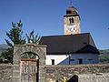
Reformed Church of Duvin

View of Duvin GR in Lugnez


literature
- Adolf Collenberg: Duvin. In: Historical Lexicon of Switzerland . 2016 .
- Christian Caduff: Duvin, a mountain community that does without tourism. In: Bündner Zeitung of December 17, 1983.
- Duri Blumenthal, Armin Caduff, Curdin Casaulta, Peter Schmid: cultural guide Val Lumnezia and Vals. Vella 2000, p. 195 f.
Web links
Individual evidence
- ↑ Lexicon of Swiss municipality names . Edited by the Center de Dialextologie at the University of Neuchâtel under the direction of Andres Kristol. Frauenfeld / Lausanne 2005, p. 308.
- ^ Catholic branch church St. Luzius
- ^ Schoolhouse
- ↑ Glenner Bridge
Breil / Brigels | Disentis / Mustér | Falera | Ilanz / Glion | Laax | Lumnezia | Medel (Lucmagn) | Obersaxen Mundaun | Safiental | Sagogn | Schluein | Sumvitg | Trun | Tujetsch | Vals
Former parishes: Andiast | Camuns | Castrisch | Cumbel | Sword | Duvin | Flond | Ilanz | Ladir | Lumbar clean | Luff | Morissen | Mundaun | Obersaxen | Peiden | Pigniu | Pitasch | Riein | Rueun | Ruschein | Safien | Slim | Schnaus | Sculms | Sevgein | Siat | St. Martin | Strada | Suraua | Surcasti | Surcuolm | Tenna | Tersnaus | Uors | Uors-Peiden | Valendas | Vella | Versam | Vignogn | Vrin | Waltensburg / Vuorz
Canton of Graubünden | Regions of the Canton of Graubünden | Municipalities of the Canton of Graubünden