
Pitasch
| Pitasch | ||
|---|---|---|
 |
||
| State : |
|
|
| Canton : |
|
|
| Region : | Surselva | |
| Political community : | Ilanz / Glion | |
| Postal code : | 7111 | |
| former BFS no. : | 3578 | |
| Coordinates : | 736 155 / 176 967 | |
| Height : | 1060 m above sea level M. | |
| Area : | 10.79 km² | |
| Residents: | 99 (December 31, 2013) | |
| Population density : | 9 inhabitants per km² | |
| Website: | www.ilanz-glion.ch/fraktionen/pitasch.html | |
 Pitasch |
||
| map | ||
|
||


Pitasch ( ) was a political municipality in Val Lumnezia in the then Surselva district of the Swiss canton of Graubünden until December 31, 2013 . On January 1, 2014 Pitasch merged with the former municipalities of Castrisch , Duvin , Ilanz , Ladir , Luven , Pigniu , Riein , Rueun , Ruschein , Schnaus , Sevgein , Siat to form the new municipality of Ilanz / Glion .
coat of arms
Blazon : In silver (white) on a green three-mountain three green fir trees
Adoption of the seal motif from the middle of the 19th century in the coat of arms .
geography
The place is on a terrace between the Rieinertobel (Romanesque Val Renastga ) in the north and the Pitascherboden (Romanesque Val da Pitasch ) in the south. Although geographically located in the Val Lumnezia, the places Riein and Pitasch belonged politically to the Gruob , which is Romansh Foppa, because of their proximity to Ilanz and the valley of the Rhine there, even before their merger with Ilanz . The regional center of Ilanz is 4.5 km from Pitasch. Historically important was the former pass crossing over Güner Lückli into Safiental and from there on to Italy. The former municipality rose from the Glenner to the Güner Horn, (Romanesque Piz Gün , 2,851 m above sea level ) from west to east. Of the entire former municipal area of 1081 hectares, 531 hectares are covered by forest and wood. Another 339 hectares can be used for agriculture, mostly as mountain pastures . In addition to 195 ha of unproductive area (mainly mountains) there is 16 ha of settlement area.
population
| Population development | ||||||
|---|---|---|---|---|---|---|
| year | 1850 | 1900 | 1950 | 2000 | 2004 | 2013 |
| Residents | 96 | 105 | 125 | 118 | 117 | 99 |
In 2004, all but two residents (= 98.32%) were Swiss nationals living in the village. The majority of the population speaks Sursilvan and is reformed . The main occupation is agriculture and a few commute outside the village to the regional center of Ilanz or further down the valley to the Chur Rhine Valley. Today the population is bilingual. The school location is Ilanz. At the entrance to the Pitascher Tobel valley, the access road to this terrace and meadow village branches off at the Pitascher Mühle (a restaurant), which has a considerable amount of forest. For a long time, Pitasch was a holiday resort for those seeking relaxation from the Blue Cross and was able to stabilize its population thanks to second homes. Social life takes place in village associations. The reformed parish of Pitasch is part of the pastoral community Luven / Flond / Pitasch / Duvin.
history
There are no signs of early settlement. Pitasch is mentioned as "Pictaui" in 801-850 and as "Pictaso" in 960 in documents from the 16th century. The Graubünden historian Otto Clavadetscher suspected a stem that was also based on the French city of Poitiers. Pictaui was the Roman name for a settlement at a fork in the road. The route from Ilanz to Pitasch via Güner Lückli played an important role as a transit route to the south and for the cattle trade in Lombardy until the opening of the Viamala route in 1473. It was also often used by the Walsers of the Safien valley. The mountain pass also played an important role in European middling traffic over the Alpine passes. In 1477 the Maierhof von Pitasch and the Alp Moliet (located on the pass path to Güner Lückli) were performed by the Lugnez bailiffs Gilli de Mont and Hertli von Capol from Villa. They controlled and maintained the pass route into the Safien Valley and towards Italy.
A royal estate is proven in Pitasch as early as 840. Emperor Otto I, the Great, then transferred his property to the Bishop of Chur, who remained fiefdom until 1538. Excavations at the Reformed Church also testify to a nun's gate, which proved the influence of the Cazis monastery in Pitasch. In the Middle Ages, various episcopal ministerial families ruled in Pitasch and Castrisch as fiefdoms. Successors were the barons of Belmont and, after they died out, those of Sax-Misox . The latter sold their rulership rights to the Chur bishop in 1483. The Reformation took place in 1526 and twelve years later the Pitaschers bought themselves free. Together with Riein they formed a reformed parish, at times also with the neighboring village of Duvin . In modern times, village life was mainly characterized by everyday rural life. The village image is largely still intact.
Attractions
The reformed church was built around 950. On the north facade there are pictures of the Waltensburg master .
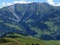
Signina group with Pitasch on the right and Riein on the left
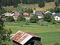
Pitasch with a view of Riein
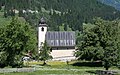
Reformed Church Pitasch

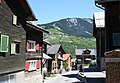
Old post office in Pitasch

View to Pitasch from Riein
Pitasch seen from the east


literature
- Martin Bundi: Pitasch. In: Historical Lexicon of Switzerland . 2016 .
- The municipalities of the canton of Graubünden. Rüegger, Chur / Zurich 2003, ISBN 3-7253-0741-5 .
Web links
- [1] Pitasch im e-lir (Rhaeto-Romanic)
Individual evidence
- ^ Reformed Parish Pitasch ; Pastoral community Luven / Flond / Pitasch / Duvin
- ↑ Denise Ellenberger: Church Pitasch GR (= Swiss Art Guide. No. 432). Edited by the Society for Swiss Art History. Bern 1988.
Breil / Brigels | Disentis / Mustér | Falera | Ilanz / Glion | Laax | Lumnezia | Medel (Lucmagn) | Obersaxen Mundaun | Safiental | Sagogn | Schluein | Sumvitg | Trun | Tujetsch | Vals
Former parishes: Andiast | Camuns | Castrisch | Cumbel | Sword | Duvin | Flond | Ilanz | Ladir | Lumbar clean | Luff | Morissen | Mundaun | Obersaxen | Peiden | Pigniu | Pitasch | Riein | Rueun | Ruschein | Safien | Slim | Schnaus | Sculms | Sevgein | Siat | St. Martin | Strada | Suraua | Surcasti | Surcuolm | Tenna | Tersnaus | Uors | Uors-Peiden | Valendas | Vella | Versam | Vignogn | Vrin | Waltensburg / Vuorz
Canton of Graubünden | Regions of the Canton of Graubünden | Municipalities of the Canton of Graubünden