
No
| No | |
|---|---|
 |
|
| State : |
|
| Canton : |
|
| Region : | Surselva |
| BFS no. : | 3582 |
| Postal code : | 7151 |
| Coordinates : | 736 767 / 183653 |
| Height : | 762 m above sea level M. |
| Height range : | 671–1374 m above sea level M. |
| Area : | 4.79 km² |
| Residents: | 648 (December 31, 2018) |
| Population density : | 135 inhabitants per km² |
| Website: | www.schluein.ch |
 No |
|
| Location of the municipality | |
  |
|
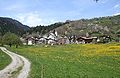
Schluein ( , German and officially Schleuis until 1983 ) is a municipality in the Surselva region of the canton of Graubünden in Switzerland .
coat of arms
Blazon : split by blue and gold; in blue a golden key and in gold an overturned blue sword
Key and sword are the attributes of Saints Peter and Paul . The coat of arms of the Lords of Löwenberg, who owned the Schleuis Freiherrschaft, provided the coat of arms colors.
geography

The Romansh-speaking ( Sursilvan ) village is located 4 km east of Ilanz in the Vorderrhein Valley , a few kilometers from the well-known Flims - Laax - Falera holiday center and the entrance to the Rhine Gorge ( Ruinaulta ).
Since December 2016, a bridge for non- motorized traffic has been connecting Schluein with Castrisch on the southern side of the Vorderrhein.
history
The village was first mentioned as Sluwen in 1298 . From the Middle Ages to 1803, Schluein was under the rule of the von Löwenberg family. The village church of St. Peter and Paul is first mentioned in 1321. To the west of the village, the Löwenberg Castle stood on a hill , but only a few remains of it remain.
Mills

The Mulin Sura (upper mill) was located above the village . The little mill that was used to pound barley and millet still stands; the big grain mill, however, has disappeared. Faint traces have been preserved from the sewer lines. The Mulin sut (lower mill) was below the country road. A saw has been driven with an additional water wheel since the 19th century and was dismantled around 1950. During the Second World War, the Schluein mills were still in great use as part of the “ Plan Wahlen ”. After 1945 the traditional mills had to give way to the modern Neumühle von Ilanz.
Attractions
Catholic Parish Church of St. Peter
No
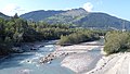
Bridge between Schluein and Castrisch
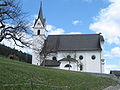
Schluein Church

Facade of the village church


Varia
The new building of Löwenberg Castle, which burned down in 1889, housed an orphanage until 1972 and today serves as a transit center for asylum seekers. This was the setting in the film “Canzun Alpina - Voices of the Heart”, which was released in September 2008.
Web links
- Adolf Collenberg: Schluein. In: Historical Lexicon of Switzerland .
- Ruinaulta natural monument
Individual evidence
- ↑ Permanent and non-permanent resident population by year, canton, district, municipality, population type and gender (permanent resident population). In: bfs. admin.ch . Federal Statistical Office (FSO), August 31, 2019, accessed on December 22, 2019 .
- ↑ Southeastern Switzerland
- ↑ Catholic parish church of St. Peter on www.graubuendenkultur.ch .
- ↑ Canzun Alpina - Voices of the Heart on the srf.ch website, accessed on June 13, 2016
- ↑ Canzun Alpina - Voices of the Heart on the swissfilms.ch website, accessed on June 13, 2016
Breil / Brigels | Disentis / Mustér | Falera | Ilanz / Glion | Laax | Lumnezia | Medel (Lucmagn) | Obersaxen Mundaun | Safiental | Sagogn | Schluein | Sumvitg | Trun | Tujetsch | Vals
Former parishes: Andiast | Camuns | Castrisch | Cumbel | Sword | Duvin | Flond | Ilanz | Ladir | Lumbar clean | Luff | Morissen | Mundaun | Obersaxen | Peiden | Pigniu | Pitasch | Riein | Rueun | Ruschein | Safien | Slim | Schnaus | Sculms | Sevgein | Siat | St. Martin | Strada | Suraua | Surcasti | Surcuolm | Tenna | Tersnaus | Uors | Uors-Peiden | Valendas | Vella | Versam | Vignogn | Vrin | Waltensburg / Vuorz
Canton of Graubünden | Regions of the Canton of Graubünden | Municipalities of the Canton of Graubünden