
Versam
| Versam | ||
|---|---|---|
 |
||
| State : |
|
|
| Canton : |
|
|
| Region : | Surselva | |
| Political community : | Safiental | |
| Postal code : | 7104 | |
| former BFS no. : | 3587 | |
| Coordinates : | 745 155 / 184 184 | |
| Height : | 909 m above sea level M. | |
| Area : | 16.79 km² | |
| Residents: | 237 (December 31, 2012) | |
| Population density : | 14 inhabitants per km² | |
| Website: | www.versam.ch | |
 Versam |
||
| map | ||
|
||


Versam (in local dialect Walser Frsam [frsam] ; Romansh Versomi ) was, until 31 December 2012, a municipality in the former county Ilanz , District Surselva the Swiss canton of Grisons .
On January 1, 2013, it merged with the municipalities of Valendas , Safien and Tenna to form the new municipality of Safiental , moving to what was then the Safien district .
coat of arms
Blazon : In silver (white) a green fir tree , accompanied by three black balls
The fir can already be found on a community seal from the middle of the 19th century. The black balls come from the coat of arms of the Lords of Valendas, who owned property in the former municipal area.
geography
The former community is located at the entrance to Safiental on a terrace on the right above the Vorderrhein and on the left above the Rabiusa . The Rhine gorge , the Ruinaulta, lies in the north of the former municipality . The place consists of the village Versam and the scattered settlements Arezen (986-1158 m) and Sculms (996-1,139 m). The hamlet of Arezen is one kilometer south of the village and Sculms is 3.2 kilometers southeast.
Of the entire former municipal area of 1677 ha, 1184 ha (= 70%) are forested and 178 ha (= 10%) are mountain. Of the 282 hectares of usable land, 69 hectares are cultivated as alpine pastures. There are also 33 hectares of settlement area.
population
| Population development | |||||||
|---|---|---|---|---|---|---|---|
| year | 1803 | 1850 | 1900 | 1950 | 2000 | 2004 | 2012 |
| Residents | 357 | 396 | 316 | 354 | 255 | 271 | 237 |
Of the 271 residents at the end of 2004, 264 (= 97%) were Swiss citizens. The population belongs to the German-speaking ethnic group of the Walser and is reformed.
Municipal council
The former municipal council consisted of five people.
traffic
Versam is connected to public transport by the Versam-Safien Station - Thalkirch and Ilanz - Versam Post bus lines . There is also a shared train station in the valley with the former municipality of Safien from the Rhaetian Railway . From there are Chur , Ilanz and Disentis reach.
The Versamerstrasse connects with Versam Bonaduz . It crosses over the Versamer Gorge bridge the Versamer Gorge and then the Ruinaulta.
education
In the former municipality there is a kindergarten and a primary school up to the 6th grade. Then the children go to school in Valendas .
Attractions
In June 2019, the Safien brewery was put into operation in the Rössli restaurant.
- The reformed village church is a listed building .
- The Gugalun House, 1994, architect: Peter Zumthor
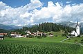
upper part of the village with church

Unterdorf

Sculm on the other side of the valley

Versam station in the Ruinaulta


literature
- Jürg Simonett: Versam. In: Historical Lexicon of Switzerland . 2013 .
- The municipalities of the canton of Graubünden. Rüegger, Chur / Zurich 2003, ISBN 3-7253-0741-5 .
Web links
Individual evidence
- ↑ Opening Safienbrauerei ( Memento of 6 June 2019 Internet Archive ), Safiental News, May 29, 2019
- ↑ Gugalun House
Breil / Brigels | Disentis / Mustér | Falera | Ilanz / Glion | Laax | Lumnezia | Medel (Lucmagn) | Obersaxen Mundaun | Safiental | Sagogn | Schluein | Sumvitg | Trun | Tujetsch | Vals
Former parishes: Andiast | Camuns | Castrisch | Cumbel | Sword | Duvin | Flond | Ilanz | Ladir | Lumbar clean | Luff | Morissen | Mundaun | Obersaxen | Peiden | Pigniu | Pitasch | Riein | Rueun | Ruschein | Safien | Slim | Schnaus | Sculms | Sevgein | Siat | St. Martin | Strada | Suraua | Surcasti | Surcuolm | Tenna | Tersnaus | Uors | Uors-Peiden | Valendas | Vella | Versam | Vignogn | Vrin | Waltensburg / Vuorz
Canton of Graubünden | Regions of the Canton of Graubünden | Municipalities of the Canton of Graubünden