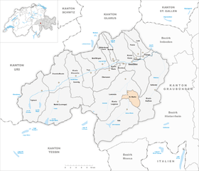
St. Martin GR
| GR is the abbreviation for the canton of Graubünden in Switzerland and is used to avoid confusion with other entries of the name St. Martin . |
| St. Martin | ||
|---|---|---|
| State : |
|
|
| Canton : |
|
|
| Region : | Surselva | |
| Political community : | Vals | |
| Postal code : | 7116 | |
| former BFS no. : | 3598 | |
| Coordinates : | 733 234 / 170 786 | |
| Height : | 1003 m above sea level M. | |
| Area : | 22.83 km² | |
| Residents: | 35 (December 31, 2013) | |
| Population density : | 2 inhabitants per km² | |
| Website: | www.vals.ch | |
|
St. Martin |
||
| map | ||
|
|
||
St. Martin (called Sogn Martin by its Romansh- neighbors ) has been part of the municipality of Vals in the Swiss canton of Graubünden since January 1, 2015 . Until December 31, 2014 St. Martin formed its own political municipality .
coat of arms
Blazon : "In blue, a saint in a silver, golden ornate episcopal regalia, flanked and underneath accompanied by seven six-pointed golden stars."
The saint in the coat of arms represents Martin of Tours , who stands for the name of the community, while the seven stars refer to the seven courtyards from which the former community was created.
geography
The small village settlement lies in a narrow-walled gorge in the Valser Valley . The formerly independent community consisted of numerous scattered settlements, many of which are now uninhabited. Individual farms can only be reached on narrow, steep mountain roads or on foot. The northernmost farmstead at the sharply narrowing slate valley section of the Valser Rhine is Sankt Martin ( 1003 m above sea level ). Further south are Gadenstatt on the left and Lunschania ( 1083 m ) on the right side of the Vals Rhine , both easily accessible via the Ilanz-Vals valley road. The farms of Munt ( 1469 m ), Mariaga ( 1601 m ) and Travisasch ( 1689 m ) , which are still managed today, are located high up in a panoramic position and can be reached on steep mountain roads or hiking trails . The southernmost hamlet of Bucarischuna ( 1167 m ) is located on the valley floor on the main road, at the entrance to the alpine area of Alp Rischuna and Alp Grava. The mountain range east of it leads to the Safiental . The highest peaks in this chain are the Piz Tomül / Weissensteinhorn ( 2946 m ), the Crap Grisch / Planggenhorn ( 2861 m ) and the Tällihorn ( 2856 m ). Of the entire former municipal area of almost 23 km², 846 hectares of mountains and 746 hectares were covered by forest and wood. 665 hectares were used agriculturally, but almost exclusively as a meadow or in the form of alpine dairy and alpine farming. The remaining six hectares of the former municipality formed settlement area. The merger with the tourist-oriented neighboring municipality of Vals and connections with the rest of the Lugnez neighborhoods, as well as the expansion of the valley and mountain roads to the individual farms, brought the residents a structural adjustment and stabilization.
history
The former municipality of St.Martin belonged to Tersnaus until 1878 , after which it became independent and merged with the neighboring municipality of Vals in 2015 for economic and structural reasons . Despite income from water interest and contributions from sponsorship communities, the small community had a high population decline and infrastructure problems, which it could often not solve alone and only in harmony with the neighborhoods, which led to a merger solution.
St. Martin was the last municipality in Switzerland to be electrified in 1972/73. The expansion of vacant properties into second homes and holiday homes also stabilized for a short time.
population
| Population development | ||||||||
|---|---|---|---|---|---|---|---|---|
| year | 1800 | 1880 | 1900 | 1941 | 1950 | 2000 | 2004 | 2013 |
| Residents | 139 | 150 | 99 | 83 | 112 | 36 | 38 | 35 |
At the end of 2004, all 38 community residents were Swiss citizens. Most of them belonged to the German-speaking ethnic group of the Walser , a few are bilingual or had the Rhaeto-Romanic idiom Sursilvan . The former municipality is now part of the Walser settlement of Vals , which is adjacent to the south in terms of cultural geography and politics, and is referred to as a part of the village or neighborhood.
Attractions
- Church with paintings by Hans Ardüser
literature
- Adolf Collenberg: Sankt Martin (GR). In: Historical Lexicon of Switzerland . 2017 .
- The municipalities of the canton of Graubünden. Chur / Zurich 2003, ISBN 3-7253-0741-5 .
- Janine Hosp: A village mistrusts itself. In: Tages-Anzeiger from September 19, 2013.


