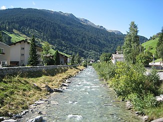
Vals Rhine
|
Valser Rhein Valserrhein (older maps) |
||
|
Vals Rhine in Vals |
||
| Data | ||
| Water code | CH : 319 | |
| location | Switzerland | |
| River system | Rhine | |
| Drain over | Glenner → Vorderrhein → Rhine → North Sea | |
| source | at the Rheinwaldhorn 46 ° 30 ′ 45 ″ N , 9 ° 2 ′ 19 ″ E |
|
| Source height | approx. 2430 m above sea level M. | |
| muzzle | at Uors in the Glenner coordinates: 46 ° 42 '11 " N , 9 ° 10' 51" E ; CH1903: 733 222 / 173 905 46 ° 42 '11 " N , 9 ° 10' 51" O |
|
| Mouth height | 855 m above sea level M. | |
| Height difference | approx. 1575 m | |
| Bottom slope | approx. 53 ‰ | |
| length | 29.5 km | |
| Catchment area | 185.75 km² | |
| Discharge at the mouth of the A Eo : 185.75 km² |
MQ Mq |
7.54 m³ / s 40.6 l / (s km²) |
| Reservoirs flowed through | Zervreila Lake | |
The Valser Rhine or Valserrhein is about 30 kilometers long right tributary of the Glenners in the Swiss canton of Grisons , which in the headwaters of the Rhine runs.
course
The river rises from the Länta and Grauhorn glaciers at the northern foot of the Rheinwaldhorn and first flows through the Länta valley before it is dammed in the Zervreila lake. When former village Zervreila from the right led horn and Canal Bach in the still ungestauten Valser Rhine. These streams are also tributaries of the reservoir today. Before the dam, the Finsterbach flows into the reservoir on the right from the south . Below the Zervreila lake, the Vals Rhine flows through the Vals valley and the municipality of Vals . The Peiler Bach flows into the river in front of Vals Platz . Behind the village, the Tomülbach joins on the right, coming from the Tomülpass . The Valser Rhine then flows on to St. Martin GR , until it flows into the Glenner (Glogn), which is naturally much less watery here at Uors and which in turn flows into the Vorderrhein after ten kilometers .
use
From the Zervreilasee, most of its water flow is diverted into a pressure line of the Zervreila power station (KWZ), which first leads to a power station in Safiental and then through the Heinzenberg to the Rothenbrunnen power station in Domleschg .
The Valser Rhein has many rapids and waterfalls and is therefore popular with canoeists .
bridges
13 road bridges and 7 pedestrian bridges cross the Vals Rhine.
Web links
Individual evidence
- ↑ a b c Geoserver of the Swiss Federal Administration ( information )
- ↑ a b Topographical catchment areas of Swiss waters: sub-catchment areas 2 km². Retrieved August 6, 2018 .
