Source of the Rhine
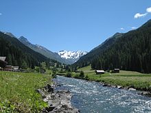
The source of the Rhine is the Tomasee in the canton of Graubünden , whose outflow rises after a few kilometers as Rein da Tuma in the Vorderrhein (Romanesque Rein Anteriur ). The course of its water is not very representative, as most of the water is taken from a water intake after just under two kilometers and fed to the Curnera reservoir . This water only sees the proximity of the Rhine bed again at the Tavanasa headquarters and returns to the Rhine at Ilanz. In the vicinity of Chur , more precisely from the union of the Hinterrhein and Vorderrhein near Reichenau , the river is exclusively called the Rhine .
Criteria for distinguishing between main and tributaries
There are various criteria for defining the main river , and depending on the definition, regardless of the name of the water body, different sources can mark the beginning of the main stream. The determination of the main strand is difficult in the river system of the front and rear Rhine, as rivers of almost the same size often meet here. In addition to the common criterion of the (at first only apparently) greater water flow, further cartographic records could be added, such as the greater length, the greater catchment area or (occasionally) the highest springs.
Decisive for the naming can be the retained flow direction or the importance of the valleys as settlement and traffic areas. Both are more likely to apply to the Vorderrhein, especially since the Hinterrhein area was hardly populated until the arrival of the Walsers .
Rhine springs by name

The source of the Rhine and the Vorderrhein is indicated on the Atlas of Switzerland of the Federal Office for Topography and the ETH Zurich north of the Rein da Tuma and the Toma lake, that of the Hinterrhein in the high valley of the Rheinwald east under the Rheinwaldhorn .
In the Rhine source area there is the special situation that there are many rivers with the name Rhine , in different ( Graubünden Romanic ) spelling variants such as Rein , Rain , Ragn , Ren , Reno or Rin .
Source of the Rhine after the largest water flow
The source of the main flow path is obtained by determining the larger river at each confluence upstream. At the confluence of the Vorder and Hinterrhein near Reichenau, the Vorderrhein leads 53.8 m³ / s and the somewhat larger Hinterrhein 59.6 m³ / s. At the confluence of the Albula , this is naturally only a little larger than the Hinterrhein (29.1 m³ / s compared to 27.3 m³ / s). At the confluence of the Landwasser in the Albula, however, the Landwasser is significantly larger (9.45 m³ / s compared to 5.57 m³ / s). Finally, when looking at the source streams of the Landwasser near Davos , it becomes apparent that the Dischmabach source branch is slightly larger than the Flüelabach source branch, including the former smaller tributary from Lake Davos .
The main hydrological flow path of the Alpine Rhine thus begins in the uppermost Dischma valley, far away from the larger rivers called the Rhine.
The current annual water level values have long since ceased to reflect this natural runoff, since in many power plants water is fed to the power stations beyond the boundaries of natural catchment areas and past important water levels; so from the southern area of the Vorderrhein to that of the Hinterrhein, from the Hinterrhein to the Albula or from the Landwasser and Albula to the lower Hinterrhein ( Albula-Landwasser power plants ). In the uppermost Landwasser area, too, water is channeled from Flüelabach and Davosersee into the neighboring valley and turbined at Aeua in Klosters .
If one applies the argument of the greater water flow beyond the Alpine Rhine to the entire river system of the Rhine , then the higher water flow of the Aare at the confluence point at Koblenz AG (560 m³ / s compared to 443 m³ / s of the Rhine) results in the gateway to the Aare glacier as a source of the Rhine.
Source of the Rhine after the greatest length
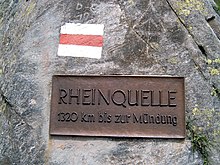
At the Tomasee, known as the “source of the Rhine”, there is a sign with the length indication “1320 km to the mouth”. The length specification of 1324 km is also common, but it is incorrect. In fact, a mistake, perhaps a number reversal, seemed to have been made over the course of the 20th century, which has since been adopted. It was not until 2010 that new measurements showed that the Rhine is actually 1233 km long.

The flow path from the source of the Rein da Tuma , which flows through the Tomasee, measures around 71 km to the confluence of the Vorder and Hinterrhein (from there it is a further 1160 kilometers to the confluence with the North Sea ). However, there are some longer flow paths in the Vorderrhein area between the source and the confluence at Reichenau:
- about 76 km: Rein da Medel (middle course also called Froda , Ticino upper course Reno di Medel )
- about 75 km: Rein da Maighels (tributary of the Rein da Curnera)
- about 74 km: Rein da Curnera
- about 71 km: Rein da Tuma (with Tomasee and the most important lake tributary)
- about 71 km: Rein da Nalps
- about 70 km: two spring streams coming down from the areas of Puozas and Milez near the Oberalp Pass
- about 70 km: the source arm Aua da Val coming down from the Val Val , which seeps under a block moraine near the point 2367 m and reappears shortly afterwards over a ledge
- about 69.5 km: Aua da Urlaun , tributary of the Rein da Tuma

The flow paths in the area of the Hinterrhein are generally a little shorter:
- about 72 km: Dischmabach
- about 70 km: Flüelabach
- about 64 km: Hinterrhein
- about 64 km: Totalpbach (former Landwasser spring branch, flows into the Davoser See and is turbined to Klosters)
- about 63 km: Julia
- about 61 km: Madrid Rhine
- approx. 56 km: Albula -Quellarm Ava da Ravais-ch from Bergün eastwards
- approx. 53 km: Albula spring arm coming from the Crap Alv Laiets near the Albula Pass
The longest source arm of both the Vorderrhein and the Rhine as a whole is therefore the Reno di Medel , which rises approx. 7.5 km south of Lake Toma , whose source and upper course are in the area of the Ticino municipality of Quinto west of the Lukmanier Pass .
Size of the catchment area
The catchment area of the Vorderrhein covers 1,512 km², that of the Hinterrhein (including the Albula and Landwasser) is only slightly larger at 1,693 km². The parts of the precipitation that run off into bodies of water (area runoff) differ only slightly from one another in the area of the Rhine source rivers, so that the sizes of the sub-catchment areas are approximately reflected in the runoff and therefore do not have to be considered separately.
Summary
Overall, there is no clear hierarchy of rivers in the headwaters of the Rhine. The two main systems, the Vorderrhein system in the west and the Hinterrhein-Albula-Landwasser system in the south and east, differ only slightly in terms of the distance from the estuary, the flow rate and the catchment area.
The uppermost Vorderrhein area and the uppermost Landwasser-System, i.e. the westernmost and the easternmost subsystem, have the springs with the highest estuary distances. According to the above, the source of the main hydrological flow path would be on the eastern edge, in the valley of the Dischma stream.
See also
Individual evidence
- ↑ Light version of the Atlas of Switzerland with illuminated rivers ( Memento of the original from May 4, 2011 in the Internet Archive ) Info: The archive link has been inserted automatically and has not yet been checked. Please check the original and archive link according to the instructions and then remove this notice.
- ↑ a b Hydrological Atlas of Switzerland of the Federal Office for the Environment FOEN, Table_54
- ↑ The measuring locations can be identified and observed on the FOEN website
- ↑ Length of the Rhine (Update 2015) | International Commission for the Hydrology of the Rhine Basin (KHR). Retrieved April 22, 2019 .
- ↑ Christopher Schrader, Berit Uhlmann: Century error . In: sueddeutsche.de . 2010, ISSN 0174-4917 ( sueddeutsche.de [accessed on April 22, 2019]).

