
Rheinwald
| Rheinwald | ||
|---|---|---|
 The Rheinwald with Sufnersee and Splügen GR |
||
| location | canton of Grisons | |
| Waters | Hinterrhein , Sufnersee | |
| Mountains | Central Alps , Adula Alps , Oberhalbstein Alps | |
| Geographical location | 744 255 / 157339 | |
|
||
| Type | Kerbtal | |
| height | 1250 to 3402 m above sea level M. | |
| length | 26 km | |
| particularities | San Bernardino Pass , Splügen Pass | |

The Rhine Forest (from Latin vallis rheni, "Rheintal", advises. Valrain ) is the uppermost of three valleys through which the Hinterrhein River in the canton of Graubünden in Switzerland flows.
Rheinwald was the name of a merger project between the municipalities of Hinterrhein (BFS No. 3691), Nufenen (BFS No. 3693), Splügen (BFS No. 3694) and Sufers (BFS No. 3695). The municipality of Rheinwald , which was newly formed on January 1, 2019, includes the project partners excluding the municipality of Sufers.
geography

The approximately 26 km long, predominantly west-east running Rheinwald is bordered on both sides of the valley by three-thousanders. The highest peaks are the Rheinwaldhorn ( 3402 m ) in the west and the Pizzo Tambo (3279 m) in the south. The Hinterrhein leaves the valley at the entrance to the Rofflaschlucht gorge , the border to Schams , at an altitude of 1250 m .
Two pass roads lead south from the Rheinwald: the San Bernardino into Misox and the Splügenpass into the Italian Val San Giacomo . The winter secure connection through the San Bernardino tunnel ( motorway A13 ) was opened 1967th Mule tracks over the Safierberg and the Valserberg connect the valley with its northern neighbors Safien and Vals as well as through the Val Curciusa to the south via Bocchetta di Curciusa once more with San Bernardino.
The village settlements are all north of the river, between 1420 m and 1620 m high, at the foot of the moderately rising slope on the sunny side , covered by extensive alpine meadows . Further Alps extend on the southern valley flank, which is divided by several side valleys.
Localities
_wappen.svg)
Splügen is the economic and cultural center of the valley . The former Rheinwald district comprised the former municipalities of Hinterrhein , Nufenen , Splügen and Sufers , while Val Curciusa , which orographically belongs to the Rheinwald, belongs to the municipality of Mesocco.
history
Although the Romans were already busy using the pass routes via Splügen and San Bernardino, the valley was only sparsely populated by Romans until the high Middle Ages. In the 13th century, at the instigation of the Barons von Sax -Misox and the Barons von Vaz Walser -Colonists immigrated to the Rhine Forest, whose language and culture have shaped the valley to this day. The inheritance letter of 1286 documents the legal relationships between the settlers and their sovereign.
In 1337, after the death of the last Vazer, the Rheinwald came to the Counts of Werdenberg-Sargans as marriage property . They sold it in 1493 to the Trivulzio noble family from Milan . The umbrella relationship with the Trivulzio was only dissolved in 1616, and after buying out the last interest obligations, the Rheinwaldners achieved full autonomy within the Gray League , to which they had belonged since 1400, in 1636 .
Around 1530 the Rheinwald accepted the Reformation through Pastor Leonhard Seiler .
In 1638 and 1732 almost all of Sufers and in 1716 almost all of Splügen fell victim to a fire. With the decline in pass traffic since the Gotthard Railway was built , the Rheinwald lost a third of its population within eighty years: while 1143 people lived in the valley in 1781, it was 1274 in 1850, 899 in 1900 and 764 in 1930. It was still in the 18th century Nufenen the most populous place; Splügen only surpassed this in the 19th century.
In 1942 the consortium Kraftwerke Hinterrhein was founded, which initially planned a reservoir in the Rhine Forest. Because the village of Splügen would have been flooded, a protest movement arose which led to the abandonment of this project. Instead, the Lago di Lei reservoir was created .
- photos

View down the valley towards Splügen

the upper part of the Rheinwald

the Guggernüll

near Splügen, around 1920
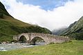
the old Landbrugg of Bernardinostrasse

_mit_Marschol-,_Rheinquell-_und_H%C3%B6hberghorn.jpg)


literature
- Kurt Wanner: Rheinwald. In: Historical Lexicon of Switzerland .
- Kurt Wanner: Out and about on Walser trails. Chur 1993, ISBN 3-905241-36-6 .
- Christian Lorez: Farm work in the Rhine forest. Agricultural methods and equipment and their terminology in the oldest documented Walser colony in Bündens (= writings of the Swiss Society for Folklore. Volume 25). Swiss Society for Folklore and Helbing & Lichtenhahn, Basel 1943 (reprinted 1987).
- Christian and Tilly Lorez-Brunold: Rheinwalder Dialect Dictionary (= grammars and dictionaries of Swiss German in a generally understandable presentation. Volume 11). Chur 1987, ISBN 3-908133-38-6 .
- Erika Hössli: Äs Ääli. Lexicon of Dying Words. Splügen 2007, ISBN 978-3-909210-01-5 .
- Bündner monthly newspaper 4/2016: Battle of the Rhine Forest.
See also
Web links
- Rheinwald on the ETHorama platform
Individual evidence
- ^ Christian Lorez: Farm work in the Rheinwald. Agricultural methods and equipment and their terminology in the oldest documented Walser colony in Bündens (= writings of the Swiss Society for Folklore. Volume 25). Swiss Society for Folklore and Helbing & Lichtenhahn, Basel 1943 (reprinted 1987), p. 8.
- ↑ History of the Hinterrhein power plants , accessed on December 3, 2018.