
Old Landbrugg
Coordinates: 46 ° 31 ′ 44 " N , 9 ° 12 ′ 7" E ; CH1903: 735282 / 154575
| Old Landbrugg | ||
|---|---|---|
 |
||
| use | Pedestrian | |
| Convicted | Hinterrhein | |
| place | Hinterrhein GR | |
| construction | Arch bridge | |
| overall length | 38 m | |
| width | 4.2 m | |
| Longest span | 13 m | |
| Clear height | 4.5 m | |
| building-costs | 330 guilders | |
| completion | 1693 | |
| planner | Peter Zurr | |
| location | ||
|
||
| Above sea level | 1593 m above sea level M. | |

The Alte Landbrugg is a stone bridge in the area of the municipality of Hinterrhein in the Rheinwald in the canton of Graubünden in Switzerland . It spans the Hinterrhein in two arches, is 2.5 meters wide and almost 40 meters long. The bridge is included in the list of cultural assets of national importance in the canton of Graubünden .
history
On behalf of the Rheinwald landscape, the Hinterrhein municipality commissioned master builder Peter Zurr (also Saurr) from Bergün to build a two-arched bridge with a hexagonal central pillar south of the village across the Hinterrhein. At this point, the old mule road crossed the river over the San Bernardino pass , and then climbed steeply towards the top of the pass. The old road reached today's pass road at the top bend.
The old Landbrugg was completed in 1693, the construction costs were 300 guilders .
The new bridge partially collapsed on July 1, 1696. Master Bartolomeo Stornino from Chiavenna was commissioned with the reconstruction ; he received 400 guilders for his work. As a result, the bridge was damaged several times by floods. In 1931 the northern yoke collapsed; In 1935 it was restored with the help of the Swiss Homeland Security . The repairs can be seen on the inserted concrete elements below the bridge arch. Today the hiking trail leads from the Rheinwald over the pass to San Bernardino over the bridge.
On both sides of the railing, stone tablets are attached to the left and right at the highest point of the bridge, reminding of the construction and restoration of the bridge.
Inscription on the east side:
"RENOV. 1934 EIDGENOSSENSCHAFT KANTON GEMEINDE HEIMATSCHUTZ R. ZURLINDEN AARAU AND NUMEROUS PATRONS HAVE ALLOWED THE RENEWAL L. FREMOLI BM “
Inscription on the west side:
"ALTE LANDBRUGG BUILT IN 1693 THROUGH THE RHEIINWALD LANDSCAPE AND NEIGHBORHOOD TO THE RHIN MASTER BUILDING ZURR BERGÜN"
Surroundings

The field name Kapell on the right bank of the Rhine immediately west of the bridge indicates a chapel that has now disappeared or a wayside shrine at the river crossing.
The Neue Landbrugg , a flat three-arched stone bridge over the Hinterrhein, stands further upstream in front of the San Bernardino tunnel portal. It runs parallel to the A13 motorway and was built in connection with the construction of the commercial road from 1818 to 1823. The engineer was Richard La Nicca .
photos
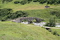
View from the north

Superstructure

West side
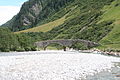
River bed west of the bridge


literature
- Erwin Poeschel : Art monuments of the canton of Graubünden. Volume V, Birkhäuser Verlag, Basel 1942, p. 256.
- Willy Zeller: Art and culture in Graubünden. Haupt Verlag, Bern 1993, p. 127.
- Ludmila Seifert, Leza Dosch: Art guide through Graubünden. Scheidegger & Spiess, Zurich 2008, p. 134.