
San Bernardino GR
| GR is the abbreviation for the canton of Graubünden in Switzerland and is used to avoid confusion with other entries of the name San Bernardino . |
| San Bernardino | ||
|---|---|---|
| State : |
|
|
| Canton : |
|
|
| Region : | Moesa | |
| Political community : | Mesocco | |
| Postal code : | 6565 | |
| Coordinates : | 734 697 / 147 189 | |
| Height : | 1608 m above sea level M. | |
| Website: | www.sanbernardino.ch | |
 View from the east |
||
| map | ||
|
||

San Bernardino is a place in the Swiss canton of Graubünden . It is located in the uppermost part of the Misox , belongs to the municipality of Mesocco and is characterized by tourism and agriculture.
geography

The place is located south of the San Bernardino Pass at an altitude of 1,600 meters at the south portal of the San Bernardino tunnel of the A13 motorway, opened in 1967 . Italian is spoken in San Bernardino. The Moësa , which rises at the San Bernardino Pass, flows through San Bernardino .
climate
The annual mean temperature is 3.9 ° C, with the coldest monthly mean temperatures of −3.6 ° C in January and the warmest mean monthly temperatures of 13.0 ° C in July. On average, around 175 frost days and 54 ice days are to be expected here. Summer days are around 0.8 on an annual average, no hot days were recorded during the normal period 1981–2010. The MeteoSwiss weather station is located at an altitude of 1639 m above sea level. M.
| San Bernadino, 1981-2010 | ||||||||||||||||||||||||||||||||||||||||||||||||
|---|---|---|---|---|---|---|---|---|---|---|---|---|---|---|---|---|---|---|---|---|---|---|---|---|---|---|---|---|---|---|---|---|---|---|---|---|---|---|---|---|---|---|---|---|---|---|---|---|
| Climate diagram | ||||||||||||||||||||||||||||||||||||||||||||||||
| ||||||||||||||||||||||||||||||||||||||||||||||||
|
Average monthly temperatures and rainfall for San Bernadino, 1981–2010
Source:
|
||||||||||||||||||||||||||||||||||||||||||||||||||||||||||||||||||||||||||||||||||||||||||||||||||||||||||||||||||||||||||||||||||||||||||||||||||||||||||||||||||||||||||||||||||||
development
In the Middle Ages the settlement was called Gualdo de Gareda . Gualdo possibly goes back to the Lombard word for "forest", Gareda to a personal name, a previous owner. In the 17th century, the name of the church patron, St. Bernardine of Siena , became the place name .
An existing sour spring was used in a guest house and spa house built from 1822; in 1825 "many" Milanese were present as spa guests.
At the beginning of the 1960s, the Moësa was dammed south of the village into the Lago d'Isola reservoir. After the opening of the San Bernardino Tunnel in 1967, the previously isolated village experienced an upswing. A great deal of construction began, not always to the advantage of the appearance of the place.
Until 2012, San Bernardino was mainly known as a ski area; there were 40 kilometers of ski slopes up to an altitude of 2600 meters. Most of the ski lifts are now out of date and have been closed since 2012 due to a lack of investors. This also has negative effects on the hotel industry, trade and the entire local economy.
Cross-country skiers can choose from 24 km of trails (classic and skating ). They are medium to easy and lead through the coniferous forest that surrounds the place. South of the village is the small moor lake Lago Dosso .
Mineral water spring
The fact that the San Bernardino mineral water spring was already known to the Romans is proven by wooden troughs that were found during construction work at the spring in 1860. In 1717 the water was examined by Johann Jakob Scheuchzer and then approved as a medicinal product. In 1829 a building was built to protect the spring; In 1860 the building was expanded.
San Bernardino's mineral water contains bicarbonate , sulfate , lime and magnesium. The temperature of the spring water is between 8.5 and 9 ° C. Today, iron is removed from the mineral water San Bernardino before it is bottled. The water can be drunk directly from a tap in front of the building in which the spring is taken.

Mineral water spring
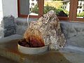
drinking fountain


Attractions
- The San Bernardino chapel above the village was first mentioned in 1467. It was built after the canonization of Bernardino of Siena at the instigation of Count Heinrich von Sax-Misox .
- The Catholic Church of San Bernardino was built between 1867 and 1897 by G. Gloria from Milan and consecrated in 1897. It is an imitation of the Chiesa San Carlo al Corso in Milan. The dome roof covered with stone slabs is noteworthy.
- The hospice
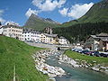
View of the village on the Moësa
In the background the Piz Uccello
chapel

Interior of the chapel

church


Hotel Brocco e Posta

View from Motton, Alp de Confin, over San Bernardino into Val Vignun with Piz Cavriola and Piz de la Lumbreida
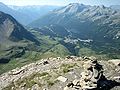
View from Piz Uccello over San Bernardino to the south into Misox

San Bernardino around 1825


literature
- Cesare Santi: San Bernardino (settlement). In: Historical Lexicon of Switzerland .
Web links
- Tourism San Bernardino on sanbernardino.ch
- San Bernardino GR at ethorama.library.ethz.ch/de/node
- Cesare Santi: Il level di San Bernardino nel 1467.
Individual evidence
- ↑ Climate table. In: meteoschweiz.admin.ch. meteoschweiz, accessed on May 31, 2018 .
- ↑ J. Jakob Meyer: The new roads through the canton of Graubünden to Lake Langen and Lake Como. Zurich 1826, p. 92.
- ↑ Cesare Santi: Misox. In: Historical Lexicon of Switzerland .
- ↑ Peter Jankovsky: San Bernardino's ski lifts are down again , NZZ, Zurich January 20, 2015
- ↑ San Bernardino Chapel
- ↑ Catholic Church of San Bernardino
- ↑ Hospice