
Val Vignun

The Val Vignun is a high alpine valley in the Swiss canton of Graubünden . In addition to the San Bernardino Pass, it represents a transition from the Misox to the Rheinwald .
The Val Vignun leads from San Bernardino in a north-easterly direction into the Val Curciusa , a side valley of the Rheinwald. It is around 5 kilometers long and is traversed by the Ri de Fontanalba , which joins the Moësa at San Bernardino .
A well-marked mountain path leads from the village of San Bernardino in several stages to the Cassina de Vignun alpine hut ( 2115 m above sea level ), where the actual high valley begins. The valley rises steadily to the top of the pass Strec de Vignun ( 2372 m above sea level ) ( Vignunsengpass in Lombard ), where it merges into Val Curciusa. The European watershed runs over the Strec de Vignun .

In the middle of the valley, at an altitude of 2300 m, the mighty rocky hill of the Motta de Caslasc rises between two flood plains . On the wide rocky knoll with an extension of around 100 by 60 meters there are terraces on the northern and southern edge of the plateau, which were probably created artificially. A feudal castle can be ruled out due to the altitude. Presumably it is a high alpine settlement from an indefinite period with a defensive character and / or a place of escape. Remains of the wall cannot be made out.
To the north of the valley is Piz Uccello , which can be reached from Val Vignun via a marked mountain path. In the south is the Piz de la Lumbreida . Apart from the alpine hut, the valley has remained completely untouched. Because of its particular beauty, the area of the San Bernardino Pass and the Val Vignun is classified as a landscape of national importance.
gallery
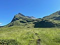
Ascent, Piz Uccello on the left

Cassina de Vignun

Pian Grand

Terrace on the Motta Caslasc

Marble block


Web links
Individual evidence
- ↑ Otto P. Clavadetscher, Werner Meyer : The Burgenbuch von Graubünden . Zurich 1984
- ↑ admin.ch
Coordinates: 46 ° 29 '49 " N , 9 ° 13' 23" E ; CH1903: seven hundred thirty-six thousand nine hundred seventy-seven / 151072