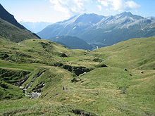
Ri de Fontanalba
| Ri de Fontanalba | ||
|
Waterfall above San Bernardino |
||
| Data | ||
| Water code | CH : 5066 | |
| location | Canton of Graubünden , Switzerland | |
| River system | Po | |
| Drain over | Moësa → Ticino → Po → Adria | |
| source | in Val Vignun 46 ° 29 ′ 51 ″ N , 9 ° 14 ′ 18 ″ E |
|
| Source height | approx. 2330 m above sea level M. | |
| muzzle | near San Bernardino in the Moësa coordinates: 46 ° 27 ′ 49 " N , 9 ° 11 ′ 29" E ; CH1903: 734 626 / 147298 46 ° 27 '49 " N , 9 ° 11' 29" O |
|
| Mouth height | 1609 m above sea level M. | |
| Height difference | approx. 721 m | |
| Bottom slope | approx. 11% | |
| length | approx. 6.8 km | |
| Catchment area | 14.45 km² | |
| Discharge at the estuary A Eo gauge : 14.45 km² |
MQ Mq |
820 l / s 56.7 l / (s km²) |
| Right tributaries | Riale di Val Vignun, Ri de Pescion | |
The Ri de Fontanalba ( Lombard for "river of the white source"; originally from Latin) is a mountain stream about 7 kilometers long above the village of San Bernardino in the municipality of Mesocco in the canton of Graubünden .
The source area of the brook lies in the Val Vignun below the Strec de Vignun between the Piz Uccello and the Piz Vignun at an altitude of around 2300 m. ü. The water collects in the partly flat, swampy valley floor and flows southwest towards San Bernardino. In the forest area above the village, the brook flows through a gorge and forms a waterfall.
In San Bernardino it takes the Ri di Pescion on the right and unites shortly afterwards at an altitude of 1605 m. ü. M. with the Moësa flowing down from the top of the San Bernardino pass .


Individual evidence
- ↑ a b c Geoserver of the Swiss Federal Administration ( information )
- ↑ a b Modeled mean annual discharge. In: Topographical catchment areas of Swiss waters: sub-catchment areas 2 km². Retrieved August 10, 2017 .
