
Piz Uccello
| Piz Uccello | ||
|---|---|---|
 Piz Uccello |
||
| height | 2723 m | |
| location | Graubünden, Switzerland | |
| Dominance | 0.4 km → Piz Cavriola | |
| Notch height | 46 m ↓ unnamed notch | |
| Coordinates | 735 106 / 151 369 | |
|
||

The Piz Uccello (German Vogelhorn ) is a mountain northeast of the village of San Bernardino in the canton of Graubünden in Switzerland . It is 2723 m high and lies on the border between the Valle Mesolcina and the Rhine Forest .
The San Bernardino Pass was formerly known as the Vogelberg Pass , its old Celtic name was Ouxello (height).
The distinctive pyramid-shaped mountain is considered the landmark of the village of San Bernardino. Its south-east side rises evenly from Val Vignun , while its north-west side drops almost perpendicularly to the San Bernardino pass and towards the Hinterrhein . The headwaters of the Ri de Fontanalba are located in Val Vignun on the south side of Piz Uccello .
A well-marked mountain path ( T2 ) leads through Val Vignun to Alp Cassina da Vignun ( 2115 m ). Since autumn 2006 the path from Val Vignun has been marked as an alpine route . The 2318 meter high south summit can easily be climbed via a narrow, steeply rising path to the ridge . The last few meters require some surefootedness (T4): The path leads over slate slabs that can easily slide. Two particularly sensitive areas are secured with chains. The main peak, five meters higher, is around 500 meters further north; no way leads to him.
In winter, Piz Uccello is a popular destination for ski tours.

Uccello chain above the Val Vignun

Waymarking

summit
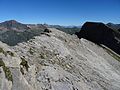
The way from the ridge to the summit, secured with chains
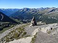
View from the summit to the south over
San Bernardino, in the background the Lago d'Isola


Web links
- Piz Uccello at ethorama.library.ethz.ch/de/node
Individual evidence
- ↑ Cultural area Via Mala ( page no longer available , search in web archives ) Info: The link was automatically marked as defective. Please check the link according to the instructions and then remove this notice.