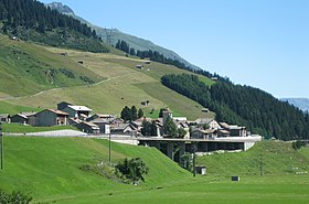
Hinterrhein GR
| GR is the abbreviation for the canton of Graubünden in Switzerland and is used to avoid confusion with other entries of the name Hinterrhein (disambiguation) . |
| Hinterrhein | ||
|---|---|---|
| State : |
|
|
| Canton : |
|
|
| Region : | Viamala | |
| Political community : | Rheinwald | |
| Postal code : | 7438 | |
| former BFS no. : | 3691 | |
| Coordinates : | 735 117 / 155 075 | |
| Height : | 1624 m above sea level M. | |
| Area : | 48.30 km² | |
| Population density : | 1 inhabitant per km² | |
| Website: | www.rheinwald.ch | |
|
Hinterrhein GR |
||
| map | ||
|
|
||
Hinterrhein ( Rhaeto-Romanic Valragn ) was a political municipality in the Viamala region in the canton of Graubünden in Switzerland until December 31, 2018 .
On January 1, 2019, the Hinterrhein municipality merged with Nufenen and Splügen to form the newly formed Rheinwald municipality .
history
The community is the first place on the Hinterrhein and the starting point for the San Bernardino Pass , which was first mentioned around 942 as mons avium , later called Vogelberg and from around 1500 St. Bernardino. The Ecclesia Sancti Petri de Reno (the listed Reformed village church ) was owned by the Lords of Sax-Misox as early as 1219.
Around 1270 the first Walser came from Val Formazza via the Misox to Hinterrhein. This made Hinterrhein the oldest Walser settlement in Graubünden. In 1274 two settlers from Hinterrhein signed a vassal contract with Lord von Sax-Misox . But Baron Walter IV von Vaz , who owned the Schams and the area as far as Splügen, which was still populated by Romans, as an episcopal fiefdom , tried in 1277 for a protection treaty with the Theutunici von Hinterrhein. In 1286 the monastery of San Vittore handed over the land in the valley to the colonists in Hinterrhein as an inheritance for an annual interest of 16 pounds. This interest obligation was not replaced until 1773 with 100 Lire di Milano. This inheritance contract names the origin of 16 colonists: Val Formazza (Pomatt), Simplon , Brig , Valle Maggia . The term Walser first appeared in this area around 1599.
With the construction of the commercial road Chur - Bellinzona in 1820 and the opening of the Gotthard Railway in 1882, the people of the Hinterrheiner lost the source of income from the centuries-old framing . The Alte Landbrugg over the Hinterrhein comes from the time of the framing . Thanks to the San Bernardino road tunnel opened in 1967, Hinterrhein can now be easily reached from the north and south in both summer and winter. Milan and Zurich can be reached in two hours.
In 1995 the school in Hinterrhein was closed and the children have been going to school in Splügen ever since .
population
Since the community has been inhabited by Walsers since the Middle Ages, it has been one of the German-speaking communities in the canton of Graubünden for centuries. German is the only official language. Of the 97 residents at the end of 2005, 74 (= 76%) were Swiss citizens.
| year | 1781 | 1850 | 1900 | 1950 | 1980 | 1990 | 2000 | 2005 | 2016 |
|---|---|---|---|---|---|---|---|---|---|
| Residents | 171 | 163 | 147 | 94 | 75 | 68 | 105 | 97 | 68 |
| languages | 1980 census | 1990 census | 2000 census | |||
|---|---|---|---|---|---|---|
| number | proportion of | number | proportion of | number | proportion of | |
| German | 75 | 100% | 66 | 97.06% | 79 | 75.24% |
| Italian | 0 | 0.00% | 1 | 1.47% | 15th | 14.29% |
| Residents | 75 | 100% | 68 | 100% | 105 | 100% |
economy
Agriculture
In Hinterrhein you live for the most part from agriculture. In the summer, around 100 goats are herded through the village to pasture. Milk and meat are processed into organic products.
tourism
Hinterrhein is a popular starting point for hikes (Valserberg to Vals GR , San Bernardino Pass to San Bernardino and via Zapporthütte on the Haute Route into Ticino and across the Canal gap to Zervreila into the Valser Valley). The ski tour to the "Chilchalphora" (3038 m) appeals to more and more ski tourists. Few guest rooms and holiday apartments are rented in Hinterrhein.
military
In the area of the municipality, in the valley floor west of the village, there is an approx. 2.5 km large arsenal of the Swiss Army . It offers shooting and training opportunities for up to four companies and is one of the few weapon areas in Switzerland where combined arms combat can be trained.
climate
| Hinterrhein 1981-2010 | ||||||||||||||||||||||||||||||||||||||||||||||||
|---|---|---|---|---|---|---|---|---|---|---|---|---|---|---|---|---|---|---|---|---|---|---|---|---|---|---|---|---|---|---|---|---|---|---|---|---|---|---|---|---|---|---|---|---|---|---|---|---|
| Climate diagram | ||||||||||||||||||||||||||||||||||||||||||||||||
| ||||||||||||||||||||||||||||||||||||||||||||||||
|
Average monthly temperatures and precipitation for Hinterrhein 1981–2010
Source:
|
||||||||||||||||||||||||||||||||||||||||||||||||||||||||||||||||||||||||||||||||||||||||||||||||||||||||||||||||||||||||||||||||||||||||||||||||||||||||||||||||||||||||||||||||||||
Web links
- Kurt Wanner: Hinterrhein. In: Historical Lexicon of Switzerland .
- Hinterrhein GR on the ETHorama platform
Individual evidence
- ↑ Hinterrhein shooting range. Retrieved April 28, 2018 .
- ↑ Archive link ( Memento of the original from September 20, 2011 in the Internet Archive ) Info: The archive link was inserted automatically and has not yet been checked. Please check the original and archive link according to the instructions and then remove this notice. , accessed November 8, 2011
- ↑ Climate table. (PDF) In: meteoschweiz.admin.ch. meteoschweiz, accessed on May 31, 2018 .


