Primal mine
| Primal mine | |
|---|---|
| State : |
|
| Canton : |
|
| Region : | Viamala |
| BFS no. : | 3670 |
| Postal code : | 7427 |
| Coordinates : | 750109 / 173 021 |
| Height : | 1264 m above sea level M. |
| Height range : | 911–2235 m above sea level M. |
| Area : | 4.33 km² |
| Residents: | 154 (December 31, 2018) |
| Population density : | 36 inhabitants per km² |
|
Primal mine |
|
| Location of the municipality | |
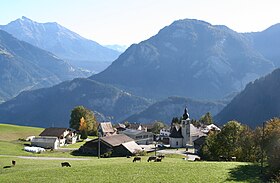
Urmein ( Romansh Urmagn ) is a municipality in the Viamala region in the canton of Graubünden in Switzerland.
coat of arms
Blazon : In red half a golden (yellow) lion with a golden arrow in the right paw
Modification of the coat of arms of the Dönz family, which led the lion with the arrow in the blue field. The colors are based on the old Heinzenberg court coat of arms.
geography
Urmein is a clustered village on the Heinzenberg and is located west of Thusis . To the south of the village, the Nolla flows through a deep gorge and to the west of it rises the Glaser Grat (2124 m). Beyond the Nollatobel, the municipality rises up to the vicinity of the Zwölfihorn (2280 m). The holiday village of Oberurmein (1527–1609 m) belongs to Urmein.
Of the entire 435 hectare municipal area, 172 hectares are forested and 34 hectares are mountain. The agriculturally usable soil covers 204 ha, of which only a small part is cultivated as alpine meadows. The remaining 25 hectares are settlement areas.
population
| year | 1803 | 1850 | 1900 | 1950 | 1980 | 1990 | 2000 | 2005 | 2016 |
|---|---|---|---|---|---|---|---|---|---|
| Residents | 158 | 133 | 89 | 90 | 76 | 81 | 81 | 98 | 147 |
languages
Originally, the residents spoke Sutselvisch , a Graubünden Romance dialect. But already in the Middle Ages, under the influence of the Walsers, they changed from Tschappina to German. Until 1970 there was a linguistic minority due to immigration from the Romansh-speaking neighboring villages. Since then the community has been monolingual. This is also proven by the following table:
| languages | 1980 census | 1990 census | 2000 census | |||
|---|---|---|---|---|---|---|
| number | proportion of | number | proportion of | number | proportion of | |
| German | 73 | 96.05% | 79 | 97.53% | 80 | 98.77% |
| Romansh | 2 | 2.63% | 2 | 2.47% | 0 | 0.00% |
| Residents | 76 | 100% | 81 | 100% | 81 | 100% |
Origin and nationality
Of the 98 residents at the end of 2005, 95 were Swiss nationals.
Attractions
The reformed village church is a listed building .
literature
- Erwin Poeschel : The art monuments of the canton of Graubünden III. The valley communities Räzünser Boden, Domleschg, Heinzenberg, Oberhalbstein, Upper and Lower Engadine. (= Art Monuments of Switzerland. Volume 11). Edited by the Society for Swiss Art History GSK. Bern 1940. DNB 760079625 .
- The municipalities of the canton of Graubünden. Chur / Zurich, 2003. ISBN 3-7253-0741-5
- Mathias Kundert: The language change in Domleschg and on Heinzenberg (19th / 20th century). Commission publisher Desertina, Chur 2007, ISBN 978-3-85637-340-5 .
- Jürg Simonett: Urmein. In: Historical Lexicon of Switzerland . 2013 .
Web links
Individual evidence
- ↑ Permanent and non-permanent resident population by year, canton, district, municipality, population type and gender (permanent resident population). In: bfs. admin.ch . Federal Statistical Office (FSO), August 31, 2019, accessed on December 22, 2019 .


