
Cazis
| Cazis | |
|---|---|
 |
|
| State : |
|
| Canton : |
|
| Region : | Viamala |
| BFS no. : | 3661 |
| Postal code : | 7408 Cazis 7422 Tartar 7423 Portein 7423 Sarn 7424 Prec |
| Coordinates : | 752 231 / 176 242 |
| Height : | 659 m above sea level M. |
| Height range : | 614–2162 m above sea level M. |
| Area : | 31.18 km² |
| Residents: | 2228 (December 31, 2018) |
| Population density : | 71 inhabitants per km² |
| Website: | www.cazis.ch |
 Cazis |
|
| Location of the municipality | |
  |
|
Cazis ( Rhaeto-Romanic Cazas or Tgazas = ladle because of the trough-like location of the original municipality in the valley) is a political municipality in the Viamala region in the canton of Graubünden in Switzerland .
On January 1, 2010, the municipalities of Cazis, Portein , Präz , Sarn and Tartar merged to form the new municipality of Cazis .
geography
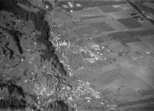
The community is located on the Heinzenberg around three kilometers northeast of Thusis and until the end of 2009 consisted of the 7 fractions (districts) Luvreu, Oberrealta, Ratitsch, Schauenberg, Summaprada, Unterrealta and Valleina. On January 1, 2010, the previously mentioned municipalities of Portein, Präz (with the Dalin and Raschlegnas fractions), Sarn and Tartar were merged as new fractions with the Cazis municipality. Of the original municipal area (until the end of 2009) of 727 hectares, 299 hectares are covered by forest and wood, 298 hectares are used for agricultural purposes, 99 hectares are settlement areas and the remaining 31 hectares are unproductive areas (mostly mountains).
history
The first settlers settled at the end of the Neolithic period on Petrus Hill , northwest of the village. Findings of bones show that they made a living from cattle breeding and hunting. Agriculture was later practiced. Up the valley was the Cresta settlement (2300-800 BC) in a crevice.
The parish church of St. Martin is located in the eastern municipality. It was probably built in the 7th century. Today it is used as a burial church. The municipality's monastery was the oldest north of the Alps. The St. Wendelin Chapel is located near the monastery and was built by pilgrims, merchants and farmers.
The two village churches St. Paul and St. Peter date from the 14th century, the stone church was built in 1996. In 1834, after the Rhine overflowed its banks after a severe storm on August 7th, a correction of the Rhine was carried out to secure the road.
In 1855 the 'Realta' was opened in Cazis and in 1919 an institution for the mentally ill. The Realta correctional facility and the Beverin Clinic developed from this . At the beginning of November 2019, the construction of the new correctional facility Cazis Tignez was completed, the keys were handed over on November 18. The new building offers space for 152 prisoners and replaces the 200-year-old prison in Chur.
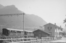
When from 1894 to 1903 the Chur-St. Moritz of the Rhaetian Railway was built, the three train stations Cazis, Rodels-Realta u. Rothenbrunnen built. In 1905 the Sernf-Nieberenbach power plant was built. It was expanded nine years later and renamed the Zervreila power station . In 1963 four primary and three secondary classes were able to move into the new Quadra school building . In 1971 the St. Catharina School was opened. In 1850, Cazis had 755 residents.
population
| Population development | ||||||||||
|---|---|---|---|---|---|---|---|---|---|---|
| year | 1803 | 1850 | 1900 | 1950 | 1970 | 1980 | 1990 | 2000 | 2005 | 2016 |
| Residents | 420 | 755 | 738 | 1441 | 1687 | 1541 | 1587 | 1575 | 1501 | 2132 |
languages
Until 1800, almost all spoke Cazner residents Sutselvisch , a Grison Roman dialect. Until 1870 the Romansh speakers had the absolute majority, in 1880 with 49% still the relative majority. But as early as 1900, slightly more than half of the population spoke German. By 1941 the proportion of Romansh speakers had fallen to 18%. The language change continues unstoppably, as the following table shows:
| Languages in Cazis GR | ||||||
| languages | 1980 census | 1990 census | 2000 census | |||
| number | proportion of | number | proportion of | number | proportion of | |
| German | 1166 | 75.67% | 1276 | 80.40% | 1326 | 84.19% |
| Romansh | 191 | 12.39% | 101 | 6.36% | 74 | 4.70% |
| Italian | 112 | 7.27% | 81 | 5.10% | 43 | 2.73% |
| Residents | 1541 | 100% | 1587 | 100% | 1575 | 100% |
About 8% of the population still understands Romansh. German is the only official language today.
Origin and nationality
Of the 1501 residents at the end of 2005, 1,286 (= 86%) were Swiss citizens.
politics
Mayor is Eduard Decurtins (CVP)
Attractions

- Monastery church of St. Peter and Paul
- Cazis Dominican Convent
- St. Wendelin Chapel
- St. Martin Church
- Luvreu Chapel
- St. Nepomuk, Oberrealta, 1994, architect: Rudolf Fontana
- Cazis stone church
- 1st place at Klinik Beverin, 2001, designer: Hans Danuser , Rita Illien , Günther Vogt
- Munté nature reserve
literature
- Erwin Poeschel : The art monuments of the canton of Graubünden III. The valley communities Räzünser Boden, Domleschg, Heinzenberg, Oberhalbstein, Upper and Lower Engadine. (= Art Monuments of Switzerland. Volume 11). Edited by the Society for Swiss Art History GSK. Bern 1940. DNB 760079625 .
- Jürg Rageth, Jürg Simonett: Cazis (community). In: Historical Lexicon of Switzerland . 2016 .
- Florian Hitz: Cazis (monastery). In: Historical Lexicon of Switzerland . 2012 .
Web links
- Cazis on the ETHorama platform
- Official website of the municipality of Cazis
Individual evidence
- ↑ Permanent and non-permanent resident population by year, canton, district, municipality, population type and gender (permanent resident population). In: bfs. admin.ch . Federal Statistical Office (FSO), August 31, 2019, accessed on December 22, 2019 .
- ↑ suedostschweiz.ch, October 18, 2019
- ↑ Parish and monastery church
- ↑ St. Wendelin Chapel
- ↑ Old parish church of St. Martin
- ↑ St. Nepomuk Chapel
- ^ Place at the Beverin Clinic
Andeer | Obverse | Casti-Wergenstein | Cazis | Domleschg | Donat | Ferrera | Flerden | Fürstenau | Wages | Masein | Mathon | Rheinwald | Rongellen | Rothenbrunnen | Sharans | Sils im Domleschg | Sufers | Thusis | Tschappina | Urmein | Zillis-Reischen . Former municipalities: Almens | Ausserferrera | Casti | Clugin | Donath | Feldis / Veulden | Hinterrhein | Innerferrera | Medels in the Rheinwald | Mutten | Nufenen | Piping | Patzen-Fardün | Pignia | Portein | Pratval | Prec | Reischen | Sledges | Sarn | Scheid | Splügen | Tartare | Tomils | Trans | Tumegl / Tomils | Wergenstein | Zillis .