
Mutten GR
| GR is the abbreviation for the canton of Graubünden in Switzerland and is used to avoid confusion with other entries of the name Mutten . |
| Mutt | ||
|---|---|---|
 |
||
| State : |
|
|
| Canton : |
|
|
| Region : | Viamala | |
| Political community : | Thusis | |
| Postal code : | 7431 | |
| former BFS no. : | 3503 | |
| Coordinates : | 757 697 / 171935 | |
| Height : | 1395 m above sea level M. | |
| Area : | 9.96 km² | |
| Residents: | 67 (December 31, 2016) | |
| Population density : | 7 inhabitants per km² | |
| Website: | www.mutten.ch | |
 Mutt |
||
| map | ||
|
||


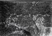
Mutten (in the Walser German local dialect Mutte [mutə] , in the Romansh neighborhood Rhaeto-Romanic Mut ) is a Walser settlement in central Grisons . It formed its own political municipality until December 31, 2017, but has belonged to the Thusis municipality since then .
coat of arms
Blazon : Divided by gold (yellow) and red, covered with two wooden houses
The two houses stand for the settlements Untermutten and Obermutten.
geography

Mutten is located on the northern slope of the Muttnerhorn and east of the Muttner Höhi between the Hinterrhein and the Albula .
The village does not have the scattered character typical of many Walser settlements, but consists of the compact village of Untermutten (1450 m, in the local dialect underem Woolt [ʊndərəm ʋoːlt] ) and the districts of Stafel (1761 m, in the local dialect Stoofel [ʃtoːfəl] ), which are only inhabited in summer. ) and Obermutten (1863 m, in the local dialect zouberscht uuff [tsoːʊbərʃt uːfː] ).
Of the total municipality area of 991 hectares, 600 hectares are covered by forest and wood. Furthermore, 292 hectares are agriculturally usable, even if mostly only as alpine pastures. Another 87 ha are unproductive areas (mostly mountains) and 12 ha are settlement areas.
history
Mutten is a settlement of the German-speaking Walser in the middle of Graubünden Romanesque communities. It is conceivable that the settlement was laid out in the 14th century by the barons of Vaz in order to secure the narrow pass strip between their properties in Schams and the Albula valley . The place name itself was originally a Romanesque field name belonging to a pre-Latin tribe * motta and * mŭtt (a) with the meaning "pile of earth" (from which Romanesque muot, muotta or Italian motta "hill, hill, hilltop"). This field name was adopted by the immigrant Walsers in the late Middle Ages and transferred to the new settlement.
In the wake of the Graubünden regional reform, the municipality of Mutten moved on January 1, 2016 from the abolished Alvaschein district ( Albula region ) to the newly founded Viamala region . On January 1, 2018, she joined the political community of Thusis.
population
| Population development | ||||||||||
|---|---|---|---|---|---|---|---|---|---|---|
| year | 1803 | 1850 | 1900 | 1910 | 1950 | 1980 | 1990 | 2000 | 2004 | 2016 |
| Residents | 98 | 132 | 193 | 99 | 125 | 83 | 81 | 80 | 87 | 67 |
languages
Since the population consists of Walsers , the community has always been German-speaking, in contrast to the surrounding area. This is also proven by the following table:
| Languages in Mutten | ||||||
| languages | 1980 census | 1990 census | 2000 census | |||
| number | proportion of | number | proportion of | number | proportion of | |
| German | 81 | 97.59% | 80 | 98.77% | 79 | 98.75% |
| Romansh | 2 | 2.41% | 1 | 1.23% | 1 | 1.25% |
| Residents | 83 | 100% | 81 | 100% | 80 | 100% |
Religion and nationality
Mutten joined the Reformation in 1582 and is the only Reformed community in the lower Albula valley.
Of the 87 residents at the end of 2004, 86 were Swiss nationals. In 2005 the first economic sector provided 83% of jobs.
societies
The seven clubs of the Mutten community enrich the cultural and sporting offer. There is a ski club, the Schützen, Walser, Samaritan and women’s association, the IG Mutten and a pure nature products association.
traffic
The road, opened in 1869, led from Calabria in the Schin Gorge over 21 turns to Mutten. Since 1903, the Albula line of the Rhaetian Railway with the Solis station in the Schin Gorge has enabled modest tourism. Since 2006, a newly constructed 6.4-kilometer single-lane road has led from the new junction on Schinstrasse in Solis via Obersolis to Mutten. It replaced the old, maintenance- intensive natural road that originated from the time of the carts. The main component of the new connection is a 1312-meter-long tunnel that safely crosses the Muttnertobel. The construction costs of the new driveway amounted to 35 million francs. The road is from the post bus line 90521 Thusis -Solis-Mutten Obermutten used.

.jpg)
.jpg)
Attractions

The Reformed village church and the wooden church in Obermutten are listed as historical monuments , both of which are stages on the Graubünden Walser Trail . Immediately next to it is the oldest house in the village, a Walser long house from 1695. It has been converted into a museum in which the permanent exhibition “Because the lamp is still glowing” can be seen.
A campaign to increase the awareness of the village brought the announcement that all followers on Facebook would be visible on a pin board; Over 40,000 portraits can be found in the International Museum Of Friendship .
literature
- Jürg Simonett: Mutten. In: Historical Lexicon of Switzerland . 2009 .
- Erwin Poeschel : The art monuments of the canton of Graubünden II. The valley communities Herrschaft, Prättigau, Davos, Schanfigg, Churwalden, Albula valley. (= Art Monuments of Switzerland. Volume 9). Edited by the Society for Swiss Art History GSK. Bern 1937. DNB 811066703 .
- The municipalities of the canton of Graubünden. Chur / Zurich 2003. ISBN 3-7253-0741-5
- Rudolf Hotzenköcherle : Mutten's dialect. Phonology and inflection theory. Huber, Frauenfeld 1934 (contributions to the Swiss German grammar XIX). - Not only about the language, but also introducing the history, settlement and construction methods as well as the population.
- Erwin Wyss: "This Gsetz isnit insschas Gsetz." Pictures of life from the Walser village of Mutten. Desertina-Verlag, Chur 2012.
Web links
Individual evidence
- ^ Linguistic Atlas of German-speaking Switzerland , Volume V, Map 1b.
- ↑ a b Municipality of Mutten GR / general improvement. (PDF file, 225 KB) Project number 1265. Swiss sponsorship for mountain communities, accessed on August 23, 2014 .
- ^ A b c Rudolf Hotzenköcherle: The dialect of Mutten. Phonology and inflection theory. Huber, Frauenfeld 1934 (Contributions to Swiss German Grammar XIX), pp. 9 and 123.
- ↑ Lexicon of Swiss municipality names . Edited by the Center de Dialectologie at the University of Neuchâtel under the direction of Andres Kristol. Frauenfeld / Lausanne 2005, p. 635.
- ↑ Mutten Thusis merger project (municipal assembly in Mutten, August 28, 2015) on mutten.ch , accessed on February 23, 2016
- ↑ Thanks to the new road, new opportunities for Mutten. (PDF file (558 KB)) Graubünden Civil Engineering Office, October 2006, accessed on August 23, 2014 .
- ↑ Jonas Schaufelberger: postautohalter.ch.vu. The website about the Swiss PostBus entrepreneurs. Retrieved August 23, 2014 .
- ^ Korean visit to the Facebook village of Obermutten , SRF, September 1, 2014
Andeer | Obverse | Casti-Wergenstein | Cazis | Domleschg | Donat | Ferrera | Flerden | Fürstenau | Wages | Masein | Mathon | Rheinwald | Rongellen | Rothenbrunnen | Sharans | Sils im Domleschg | Sufers | Thusis | Tschappina | Urmein | Zillis-Reischen . Former municipalities: Almens | Ausserferrera | Casti | Clugin | Donath | Feldis / Veulden | Hinterrhein | Innerferrera | Medels in the Rheinwald | Mutten | Nufenen | Piping | Patzen-Fardün | Pignia | Portein | Pratval | Prec | Reischen | Sledges | Sarn | Scheid | Splügen | Tartare | Tomils | Trans | Tumegl / Tomils | Wergenstein | Zillis .