
Obverse GR
| GR is the abbreviation for the canton of Graubünden in Switzerland and is used to avoid confusion with other entries of the name Avers . |
| Obverse | |
|---|---|
 |
|
| State : |
|
| Canton : |
|
| Region : | Viamala |
| BFS no. : | 3681 |
| Postal code : | 7447 |
| Coordinates : | 759 344 / 149089 |
| Height : | 1960 m above sea level M. |
| Height range : | 1554–3199 m above sea level M. |
| Area : | 93.14 km² |
| Residents: | 168 (December 31, 2018) |
| Population density : | 2 inhabitants per km² |
| Website: | www.gemeindeavers.ch |
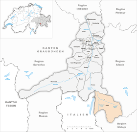
| Location of the municipality | |
  |
|
Avers (in the local Walser dialect Òòver (s) [ɔːfər ɔːfərs] , Rhaeto-Romanic Avras ) is a political municipality in the upper part of the Averstal, a side valley of the Hinterrhein in the Viamala region in the Swiss canton of Graubünden .
coat of arms
Blazon : Diagonally right divided by silver and black, in silver a jumping black, red armed ibex
The coat of arms corresponds to that of the Avers district, which was designed according to a seal of the landscape: the standing ibex was supplemented by the diagonal division in order to distinguish the coat of arms from that of the church federation.
Surname
The obverse (the name of the community is always used by the locals with an article and pronounced with a long, dark A) is a German-speaking island ( Walser German ) in the originally Rhaeto-Romanic language area. The valley name was first mentioned in 1292 and is probably related to the village of Avero northeast of San Giacomo near Chiavenna ; accordingly he would designate the "Alpine pastures of Avero".
geography
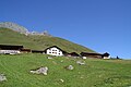
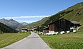
At 1960 m above sea level. M. Avers is the highest political municipality in Switzerland. The hamlet of Juf belonging to the Avers is at 2126 m above sea level. M. as the highest settlement in Europe inhabited all year round. The whole Obertal from Cresta lies above the tree line. The parish office, the school (primary school, one-class school for six years) and the church are in Cresta.
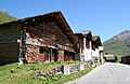
The municipality consists of different fractions: Campsut (1668 m), Cröt (1715 m), Cresta (1958 m, capital of the municipality), Pürt (1921 m), Am Bach (1959 m), Juppa (2004 m), Podestatsch Hus (2046 m) and Juf (2126 m).
The Avers Rhine flows through the Averstal .
history
The valley was not settled with a Romanesque population until the 11th century, namely through the St. Peter's hospice on the Septimerpass ; several locality names such as Cresta, Juf or Juppa bear witness to this time. After 1280 , Walsers from the Pomatt settled on the uppermost valley step, which soon spread across the entire valley and replaced the Romance language with the German ( most Alemannic ) language.
The valley was first subordinate to the city of Como and from the early 14th century to the Bishop of Chur . The formation of the congregation is attested for 1292, but certainly for 1377. The Avers joined the Church of God in 1367 , entered into an alliance with the Swiss Confederation in 1498 and became an independent judicial community of the Three Leagues in 1524/26 . In 1525/30 the obverse introduced the Reformation . The Avers was not opened up with a road until 1895.
population
| Population development | |||||||||||
|---|---|---|---|---|---|---|---|---|---|---|---|
| year | 1645 | 1850 | 1900 | 1950 | 1960 | 2000 | 2005 | 2010 | 2012 | 2014 | 2016 |
| Residents | 498 | 293 | 204 | 167 | 270 | 160 | 184 | 170 | 171 | 167 | 168 |
language
The official language of the municipality is German, as the inhabitants are Walser .
Denomination
The majority of the inhabitants of the Avers belong to the Evangelical Reformed Church in Graubünden . The valley is an independent parish.
nationality
Of the 184 residents at the end of 2005, 179 (= 97.28%) were Swiss citizens.
economy
The main occupations for a long time were alpine farming and cattle trading , today tourism plays an important role. There are hotels in Juf, Juppa and Cresta, and holiday apartments in every hamlet. There are three ski lifts in Juppa; there is also the starting point of the large cross-country ski run. Juf is a popular starting point for ski tours , or in summer for hikes over various passes to Bivio or Bergell .
The water of almost all the streams in the valley and the Madris side valley are drained into the Val-di-Lei reservoir above 1950 m through tunnels . The lake is on the north side of the Alps, but on Italian territory; the dam wall, however, in Switzerland. Only with the construction of the dam in the 1950s did the valley become a modern, paved road.
Attractions
The Reformed village church , also known as the Edelweiss Church , is a listed building.
The Alte Averserstrasse runs through the Avers . It is a comparatively young road, as the Avers was the last valley in Graubünden to have a driveway. In a huge road construction program between 1840 and 1897, all of Graubünden's valleys were developed with four to five-meter-wide roads - the one in Avers took place in 1895. For the Avers, most of their arduous shopping marches over the Madrisberg to Savogno and Chiavenna ended .
Parish partnership
Avers has maintained a partnership with the municipality of Seuzach in the canton of Zurich since 2012 .
Settlements in the Avers, from the head of the valley down the valley

Juf

Podium house
Yup
At the river
Pürt

Cresta

Crot

Campsut


literature
- Hermann Weber: Obverse. In: Historical Lexicon of Switzerland . 2009 .
- Johann Rudolf Stoffel: The high valley Avers. 1st edition 1938, new edition 2004.
Web links
- Avers GR on the ETHorama platform
- Official website of the municipality of Avers
- Federal inventory ISOS: Averser Hofweiler
Individual evidence
- ↑ Permanent and non-permanent resident population by year, canton, district, municipality, population type and gender (permanent resident population). In: bfs. admin.ch . Federal Statistical Office (FSO), August 31, 2019, accessed on December 22, 2019 .
- ^ Linguistic Atlas of German-speaking Switzerland , Volume V 1b.
- ↑ Lexicon of Swiss municipality names . Edited by the Center de Dialectologie at the University of Neuchâtel under the direction of Andres Kristol. Frauenfeld / Lausanne 2005, p. 111.
- ↑ Sponsor community Seuzach - Avers community. Retrieved on May 23, 2020 (German).
Andeer | Obverse | Casti-Wergenstein | Cazis | Domleschg | Donat | Ferrera | Flerden | Fürstenau | Wages | Masein | Mathon | Rheinwald | Rongellen | Rothenbrunnen | Sharans | Sils im Domleschg | Sufers | Thusis | Tschappina | Urmein | Zillis-Reischen . Former municipalities: Almens | Ausserferrera | Casti | Clugin | Donath | Feldis / Veulden | Hinterrhein | Innerferrera | Medels in the Rheinwald | Mutten | Nufenen | Piping | Patzen-Fardün | Pignia | Portein | Pratval | Prec | Reischen | Sledges | Sarn | Scheid | Splügen | Tartare | Tomils | Trans | Tumegl / Tomils | Wergenstein | Zillis .